Saint-Andéol-le-Château elevation
Saint-Andéol-le-Château (Auvergne-Rhône-Alpes, Département du Rhône), France elevation is 312 meters and Saint-Andéol-le-Château elevation in feet is 1024 ft above sea level [src 1]. Saint-Andéol-le-Château is a populated place (feature code) with elevation that is 138 meters (453 ft) bigger than average city elevation in France.
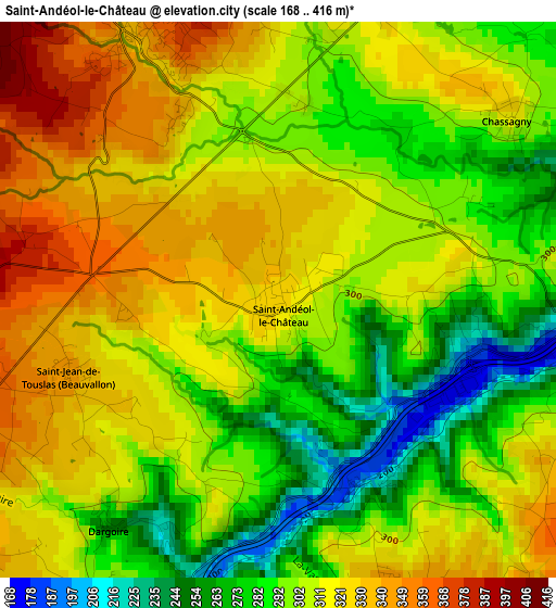
Below is the Elevation map of Saint-Andéol-le-Château, which displays elevation range with different colors. Scale of the first map is from 168 to 416 m (551 to 1365 ft) with average elevation of 305.9 meters (=1004 ft) [note 1]
These maps also provides idea of topography and contour of this city, they are displayed at different zoom levels. More info about maps, scale and edge coordinates you can find below images.
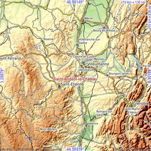
| \ | Map #1 | Topo.Map |
| Scale [m] | 168..416 m | × |
| Scale [ft] | 551..1365 ft | × |
| Average | 305.9 m = 1004 ft | × |
| Width | 6.84 km = 4.3 mi | 218.9 km = 136 mi |
| Height | 6.84 km = 4.3 mi | 218.8 km = 136 mi |
| ↑Max Latitude | 45.616716° | 46.56149° |
| Latitude at center | 45.58597° | 45.58597° |
| ↓Min Latitude | 45.555207° | 44.59319° |
| ← Min Longitude | 4.651095° | 3.28879° |
| Longitude center | 4.69504° | 4.69504° |
| →Max Longitude | 4.738985° | 6.10129° |
Nearby cities:
Cities around Saint-Andéol-le-Château sort by population:
• Givors elevation 160 m
5.8 km,  84°
84°
• Grigny 176 m
7.8 km,  71°
71°
• Mornant 363 m
4.1 km,  334°
334°
• Montagny 235 m
6.2 km,  41°
41°
• Saint-Maurice-sur-Dargoire 413 m
5 km,  265°
265°
• Orliénas 305 m
8.3 km,  12°
12°
• Taluyers 340 m
6.3 km,  19°
19°
• Saint-Joseph 327 m
6.6 km,  241°
241°
• Châteauneuf 366 m
8 km,  211°
211°
• Échalas 368 m
4.1 km,  157°
157°
• Saint-Didier-sous-Riverie 517 m
7 km,  279°
279°
• Chassagny 317 m
3.7 km,  51°
51°
Multilingual:
 En español:
Saint-Andéol-le-Château elevación 312 m.
 En France:
Saint-Andéol-le-Château élévation 312 m.
 Auf Deutsch:
Saint-Andéol-le-Château höhe über dem Meeresspiegel ist 312 m.
 На русском:
Saint-Andéol-le-Château высота над уровнем моря 312 м
Sources and notes:
- [note 1] Map square and city borders are not equal. Map elevation data is calculated only from area inside that square.
- [src 1] Elevation data from geonames database provided with same terms of usage.
- [src 2] The elevation map of Saint-Andéol-le-Château is generated using elevation data from NASA's 3 arcsec (90m) resolution SRTM data.
- [src 3] Base (background) map © OpenStreetMap contributors tiles are generated by Geofabrik and OpenTopoMap.
Copyright & License:
This Saint-Andéol-le-Château Elevation Map is licensed under CC BY-SA. You may reuse any part from this page, if you give a proper credit by linking to this URL:
 More info on terms of use page.