Saint-Antoine-l'Abbaye elevation
Saint-Antoine-l'Abbaye (Auvergne-Rhône-Alpes, Département de l'Isère), France elevation is 360 meters and Saint-Antoine-l'Abbaye elevation in feet is 1181 ft above sea level [src 1]. Saint-Antoine-l'Abbaye is a populated place (feature code) with elevation that is 186 meters (610 ft) bigger than average city elevation in France.
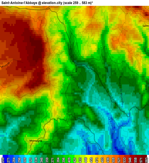
Below is the Elevation map of Saint-Antoine-l'Abbaye, which displays elevation range with different colors. Scale of the first map is from 259 to 583 m (850 to 1913 ft) with average elevation of 417.7 meters (=1370 ft) [note 1]
These maps also provides idea of topography and contour of this city, they are displayed at different zoom levels. More info about maps, scale and edge coordinates you can find below images.
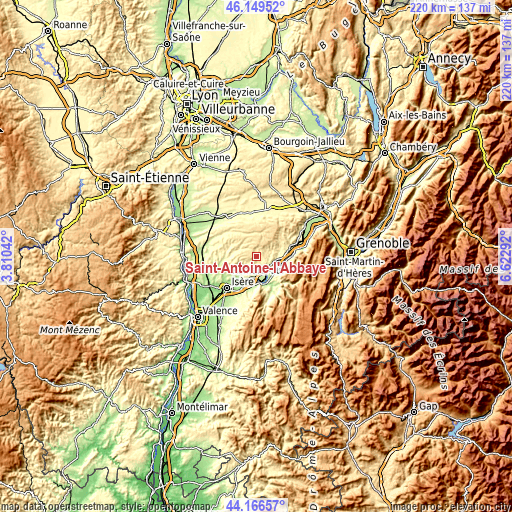
| \ | Map #1 | Topo.Map |
| Scale [m] | 259..583 m | × |
| Scale [ft] | 850..1913 ft | × |
| Average | 417.7 m = 1370 ft | × |
| Width | 6.89 km = 4.3 mi | 220.5 km = 137 mi |
| Height | 6.89 km = 4.3 mi | 220.5 km = 137 mi |
| ↑Max Latitude | 45.197645° | 46.14952° |
| Latitude at center | 45.16667° | 45.16667° |
| ↓Min Latitude | 45.135678° | 44.16657° |
| ← Min Longitude | 5.172725° | 3.81042° |
| Longitude center | 5.21667° | 5.21667° |
| →Max Longitude | 5.260615° | 6.62292° |
Nearby cities:
Cities around Saint-Antoine-l'Abbaye sort by population:
• Saint-Marcellin elevation 268 m
8.1 km,  103°
103°
• Chatte 295 m
5.8 km,  117°
117°
• Génissieux 201 m
14 km,  229°
229°
• Saint-Hilaire-du-Rosier 228 m
7.9 km,  161°
161°
• Saint-Sauveur 255 m
10.8 km, 97°
• Saint-Paul-lès-Romans 191 m
12.9 km,  210°
210°
• Saint-Vérand 294 m
9.1 km,  85°
85°
• Saint-Romans 240 m
10.2 km,  125°
125°
• Roybon 542 m
10.5 km,  12°
12°
• Saint-Just-de-Claix 210 m
11.4 km,  152°
152°
• Saint-Lattier 180 m
8.8 km,  186°
186°
• Pont-en-Royans 266 m
15.1 km,  139°
139°
Multilingual:
 En español:
Saint-Antoine-l'Abbaye elevación 360 m.
 En France:
Saint-Antoine-l'Abbaye élévation 360 m.
 Auf Deutsch:
Saint-Antoine-l’Abbaye höhe über dem Meeresspiegel ist 360 m.
 На русском:
Сент-Антуан-л’Аббеи высота над уровнем моря 360 м
Sources and notes:
- [note 1] Map square and city borders are not equal. Map elevation data is calculated only from area inside that square.
- [src 1] Elevation data from geonames database provided with same terms of usage.
- [src 2] The elevation map of Saint-Antoine-l'Abbaye is generated using elevation data from NASA's 3 arcsec (90m) resolution SRTM data.
- [src 3] Base (background) map © OpenStreetMap contributors tiles are generated by Geofabrik and OpenTopoMap.
Copyright & License:
This Saint-Antoine-l'Abbaye Elevation Map is licensed under CC BY-SA. You may reuse any part from this page, if you give a proper credit by linking to this URL:
 More info on terms of use page.