Saint-Chamond elevation
Saint-Chamond (Auvergne-Rhône-Alpes, Département de la Loire), France elevation is 355 meters and Saint-Chamond elevation in feet is 1165 ft above sea level [src 1]. Saint-Chamond is a populated place (feature code) with elevation that is 181 meters (594 ft) bigger than average city elevation in France.
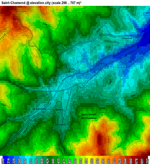
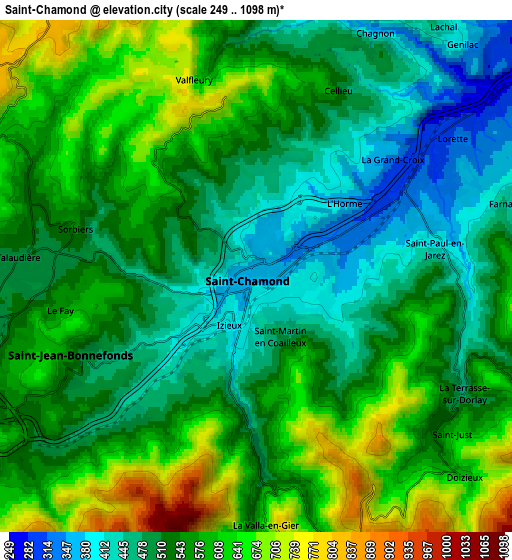
Below is the Elevation map of Saint-Chamond, which displays elevation range with different colors. Scale of the first map is from 298 to 707 m (978 to 2320 ft) with average elevation of 451.4 meters (=1481 ft) [note 1]
These maps also provides idea of topography and contour of this city, they are displayed at different zoom levels. More info about maps, scale and edge coordinates you can find below images.
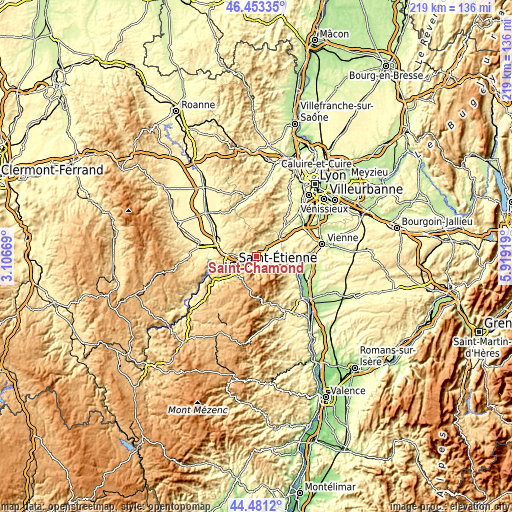
| \ | Map #1 | Map #2 | Topo.Map |
| Scale [m] | 298..707 m | 249..1098 m | × |
| Scale [ft] | 978..2320 ft | 817..3602 ft | × |
| Average | 451.4 m = 1481 ft | 548.4 m = 1799 ft | × |
| Width | 6.85 km = 4.3 mi | 13.71 km = 8.5 mi | 219.3 km = 136.3 mi |
| Height | 6.85 km = 4.3 mi | 13.71 km = 8.5 mi | 219.3 km = 136.3 mi |
| ↑Max Latitude | 45.506706° | 45.537496° | 46.45335° |
| Latitude at center | 45.4759° | 45.4759° | 45.4759° |
| ↓Min Latitude | 45.445077° | 45.414237° | 44.4812° |
| ← Min Longitude | 4.468995° | 4.425049° | 3.10669° |
| Longitude center | 4.51294° | 4.51294° | 4.51294° |
| →Max Longitude | 4.556885° | 4.600831° | 5.91919° |
Nearby cities:
Cities around Saint-Chamond sort by population:
• Rive-de-Gier elevation 249 m
9.9 km,  54°
54°
• Sorbiers 536 m
5.8 km,  286°
286°
• La Talaudière 502 m
6.8 km,  270°
270°
• Saint-Jean-Bonnefonds 486 m
5.9 km,  248°
248°
• La Grand-Croix 301 m
4.8 km, 49°
• Saint-Paul-en-Jarez 371 m
4.7 km,  77°
77°
• Saint-Martin-la-Plaine 371 m
10.2 km,  40°
40°
• Lorette 295 m
6.7 km, 54°
• Cellieu 444 m
5.3 km,  26°
26°
• Saint-Christo-en-Jarez 776 m
7.9 km,  345°
345°
• La Tour-en-Jarez 575 m
9.6 km,  275°
275°
• Farnay 367 m
5.9 km,  67°
67°
Multilingual:
 En español:
Saint-Chamond elevación 355 m.
 En France:
Saint-Chamond élévation 355 m.
 Auf Deutsch:
Saint-Chamond höhe über dem Meeresspiegel ist 355 m.

Sources and notes:
- [note 1] Map square and city borders are not equal. Map elevation data is calculated only from area inside that square.
- [src 1] Elevation data from geonames database provided with same terms of usage.
- [src 2] The elevation map of Saint-Chamond is generated using elevation data from NASA's 3 arcsec (90m) resolution SRTM data.
- [src 3] Base (background) map © OpenStreetMap contributors tiles are generated by Geofabrik and OpenTopoMap.
Copyright & License:
This Saint-Chamond Elevation Map is licensed under CC BY-SA. You may reuse any part from this page, if you give a proper credit by linking to this URL:
 More info on terms of use page.