Saint-Christophe-sur-le-Nais elevation
Saint-Christophe-sur-le-Nais (Centre, Département d'Indre-et-Loire), France elevation is 80 meters and Saint-Christophe-sur-le-Nais elevation in feet is 262 ft above sea level [src 1]. Saint-Christophe-sur-le-Nais is a populated place (feature code) with elevation that is 94 meters (308 ft) smaller than average city elevation in France.
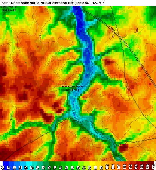
Below is the Elevation map of Saint-Christophe-sur-le-Nais, which displays elevation range with different colors. Scale of the first map is from 54 to 123 m (177 to 404 ft) with average elevation of 96.7 meters (=317 ft) [note 1]
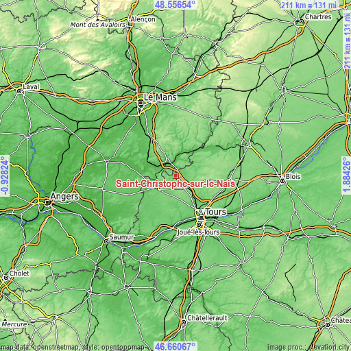
These maps also provides idea of topography and contour of this city, they are displayed at different zoom levels. More info about maps, scale and edge coordinates you can find below images.
| \ | Map #1 | Topo.Map |
| Scale [m] | 54..123 m | × |
| Scale [ft] | 177..404 ft | × |
| Average | 96.7 m = 317 ft | × |
| Width | 6.59 km = 4.1 mi | 210.8 km = 131 mi |
| Height | 6.59 km = 4.1 mi | 210.8 km = 131 mi |
| ↑Max Latitude | 47.646814° | 48.55654° |
| Latitude at center | 47.6172° | 47.6172° |
| ↓Min Latitude | 47.587569° | 46.66067° |
| ← Min Longitude | 0.434065° | -0.92824° |
| Longitude center | 0.47801° | 0.47801° |
| →Max Longitude | 0.521955° | 1.88426° |
Nearby cities:
Cities around Saint-Christophe-sur-le-Nais sort by population:
• Château-du-Loir elevation 59 m
9.7 km,  332°
332°
• Semblançay 108 m
15.2 km,  148°
148°
• Neuillé-Pont-Pierre 118 m
9.3 km,  144°
144°
• Vaas 47 m
13.4 km,  295°
295°
• La Chartre-sur-le-Loir 62 m
14.4 km,  28°
28°
• Château-la-Vallière 97 m
13.9 km,  235°
235°
• Saint-Paterne-Racan 68 m
1.8 km,  163°
163°
• Neuvy-le-Roi 118 m
8.9 km,  99°
99°
• Sonzay 104 m
10.1 km,  186°
186°
• Luceau 84 m
12.1 km, 330°
• Beaumont-la-Ronce 118 m
15.4 km,  110°
110°
• Marçon 58 m
10.7 km,  13°
13°
Multilingual:
 En español:
Saint-Christophe-sur-le-Nais elevación 80 m.
 En France:
Saint-Christophe-sur-le-Nais élévation 80 m.
 Auf Deutsch:
Saint-Christophe-sur-le-Nais höhe über dem Meeresspiegel ist 80 m.
 На русском:
Saint-Christophe-sur-le-Nais высота над уровнем моря 80 м
Sources and notes:
- [note 1] Map square and city borders are not equal. Map elevation data is calculated only from area inside that square.
- [src 1] Elevation data from geonames database provided with same terms of usage.
- [src 2] The elevation map of Saint-Christophe-sur-le-Nais is generated using elevation data from NASA's 3 arcsec (90m) resolution SRTM data.
- [src 3] Base (background) map © OpenStreetMap contributors tiles are generated by Geofabrik and OpenTopoMap.
Copyright & License:
This Saint-Christophe-sur-le-Nais Elevation Map is licensed under CC BY-SA. You may reuse any part from this page, if you give a proper credit by linking to this URL:
 More info on terms of use page.