Saint-Cyr-sur-Mer elevation
Saint-Cyr-sur-Mer (Provence-Alpes-Côte d'Azur, Var), France elevation is 40 meters and Saint-Cyr-sur-Mer elevation in feet is 131 ft above sea level [src 1]. Saint-Cyr-sur-Mer is a populated place (feature code) with elevation that is 134 meters (440 ft) smaller than average city elevation in France.
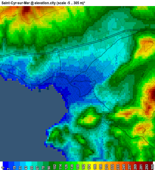
Below is the Elevation map of Saint-Cyr-sur-Mer, which displays elevation range with different colors. Scale of the first map is from -5 to 305 m (-16 to 1001 ft) with average elevation of 92.6 meters (=304 ft) [note 1]
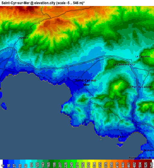
These maps also provides idea of topography and contour of this city, they are displayed at different zoom levels. More info about maps, scale and edge coordinates you can find below images.
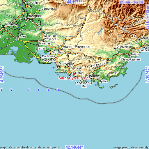
| \ | Map #1 | Map #2 | Topo.Map |
| Scale [m] | -5..305 m | -5..546 m | × |
| Scale [ft] | -16..1001 ft | -16..1791 ft | × |
| Average | 92.6 m = 304 ft | 159.4 m = 523 ft | × |
| Width | 7.13 km = 4.4 mi | 14.25 km = 8.9 mi | 228 km = 141.7 mi |
| Height | 7.13 km = 4.4 mi | 14.25 km = 8.9 mi | 228 km = 141.7 mi |
| ↑Max Latitude | 43.212517° | 43.244536° | 44.1973° |
| Latitude at center | 43.18048° | 43.18048° | 43.18048° |
| ↓Min Latitude | 43.148427° | 43.116356° | 42.14644° |
| ← Min Longitude | 5.657255° | 5.613309° | 4.29495° |
| Longitude center | 5.7012° | 5.7012° | 5.7012° |
| →Max Longitude | 5.745145° | 5.789091° | 7.10745° |
Nearby cities:
Cities around Saint-Cyr-sur-Mer sort by population:
• La Ciotat elevation 12 m
7.9 km,  265°
265°
• Sanary-sur-Mer 10 m
10.6 km,  129°
129°
• Ollioules 82 m
12.7 km,  110°
110°
• Le Beausset 185 m
8.5 km,  76°
76°
• Bandol 80 m
5.6 km,  138°
138°
• Cassis 199 m
13.8 km,  286°
286°
• Carnoux-en-Provence 251 m
13.9 km,  307°
307°
• Roquefort-la-Bédoule 287 m
11.8 km, 310°
• Le Castellet 242 m
6.6 km,  67°
67°
• Cuges-les-Pins 197 m
10.6 km,  359°
359°
• Ceyreste 123 m
6.9 km,  302°
302°
• Évenos 271 m
11.9 km,  99°
99°
Multilingual:
 En español:
Saint-Cyr-sur-Mer elevación 40 m.
 En France:
Saint-Cyr-sur-Mer élévation 40 m.
 Auf Deutsch:
Saint-Cyr-sur-Mer höhe über dem Meeresspiegel ist 40 m.

Sources and notes:
- [note 1] Map square and city borders are not equal. Map elevation data is calculated only from area inside that square.
- [src 1] Elevation data from geonames database provided with same terms of usage.
- [src 2] The elevation map of Saint-Cyr-sur-Mer is generated using elevation data from NASA's 3 arcsec (90m) resolution SRTM data.
- [src 3] Base (background) map © OpenStreetMap contributors tiles are generated by Geofabrik and OpenTopoMap.
Copyright & License:
This Saint-Cyr-sur-Mer Elevation Map is licensed under CC BY-SA. You may reuse any part from this page, if you give a proper credit by linking to this URL:
 More info on terms of use page.