Saint-Dié-des-Vosges elevation
Saint-Dié-des-Vosges (Grand Est, Vosges), France elevation is 344 meters and Saint-Dié-des-Vosges elevation in feet is 1129 ft above sea level [src 1]. Saint-Dié-des-Vosges is a seat of a third-order administrative division (feature code) with elevation that is 170 meters (558 ft) bigger than average city elevation in France.
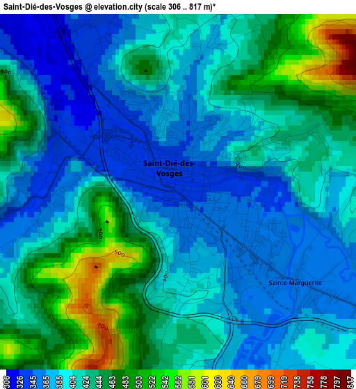
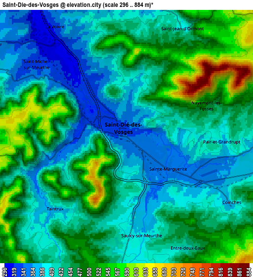
Below is the Elevation map of Saint-Dié-des-Vosges, which displays elevation range with different colors. Scale of the first map is from 306 to 817 m (1004 to 2680 ft) with average elevation of 415.4 meters (=1363 ft) [note 1]
These maps also provides idea of topography and contour of this city, they are displayed at different zoom levels. More info about maps, scale and edge coordinates you can find below images.
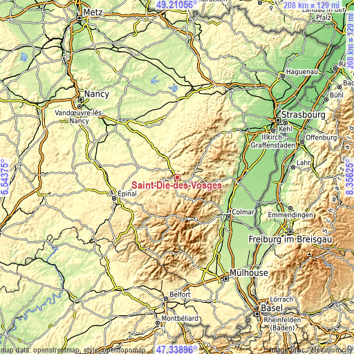
| \ | Map #1 | Map #2 | Topo.Map |
| Scale [m] | 306..817 m | 296..884 m | × |
| Scale [ft] | 1004..2680 ft | 971..2900 ft | × |
| Average | 415.4 m = 1363 ft | 449.6 m = 1475 ft | × |
| Width | 6.5 km = 4 mi | 13.01 km = 8.1 mi | 208.1 km = 129.3 mi |
| Height | 6.5 km = 4 mi | 13.01 km = 8.1 mi | 208.1 km = 129.3 mi |
| ↑Max Latitude | 48.312565° | 48.341783° | 49.21056° |
| Latitude at center | 48.28333° | 48.28333° | 48.28333° |
| ↓Min Latitude | 48.254078° | 48.22481° | 47.33896° |
| ← Min Longitude | 6.906055° | 6.862109° | 5.54375° |
| Longitude center | 6.95° | 6.95° | 6.95° |
| →Max Longitude | 6.993945° | 7.037891° | 8.35625° |
Nearby cities:
Cities around Saint-Dié-des-Vosges sort by population:
• Moyenmoutier elevation 306 m
11.1 km,  340°
340°
• Fraize 495 m
11.3 km,  161°
161°
• Anould 460 m
10.9 km,  181°
181°
• Senones 338 m
12.6 km,  9°
9°
• Étival-Clairefontaine 314 m
11.2 km,  324°
324°
• Sainte-Marguerite 357 m
3.1 km,  124°
124°
• Saulcy-sur-Meurthe 389 m
5.2 km,  168°
168°
• Saint-Michel-sur-Meurthe 316 m
6.2 km,  314°
314°
• Plainfaing 535 m
13.2 km, 158°
• Taintrux 373 m
5.3 km,  224°
224°
• Saint-Léonard 414 m
7.5 km, 183°
• Ban-de-Laveline 425 m
9.6 km, 116°
Multilingual:
 En español:
Saint-Dié-des-Vosges elevación 344 m.
 En France:
Saint-Dié-des-Vosges élévation 344 m.
 Auf Deutsch:
Saint-Dié-des-Vosges höhe über dem Meeresspiegel ist 344 m.

Sources and notes:
- [note 1] Map square and city borders are not equal. Map elevation data is calculated only from area inside that square.
- [src 1] Elevation data from geonames database provided with same terms of usage.
- [src 2] The elevation map of Saint-Dié-des-Vosges is generated using elevation data from NASA's 3 arcsec (90m) resolution SRTM data.
- [src 3] Base (background) map © OpenStreetMap contributors tiles are generated by Geofabrik and OpenTopoMap.
Copyright & License:
This Saint-Dié-des-Vosges Elevation Map is licensed under CC BY-SA. You may reuse any part from this page, if you give a proper credit by linking to this URL:
 More info on terms of use page.