Sainte-Maxime elevation
Sainte-Maxime (Provence-Alpes-Côte d'Azur, Var), France elevation is 8 meters and Sainte-Maxime elevation in feet is 26 ft above sea level [src 1]. Sainte-Maxime is a populated place (feature code) with elevation that is 166 meters (545 ft) smaller than average city elevation in France.
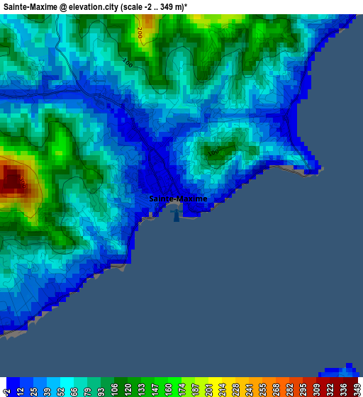
Below is the Elevation map of Sainte-Maxime, which displays elevation range with different colors. Scale of the first map is from -2 to 349 m (-7 to 1145 ft) with average elevation of 70.8 meters (=232 ft) [note 1]
These maps also provides idea of topography and contour of this city, they are displayed at different zoom levels. More info about maps, scale and edge coordinates you can find below images.
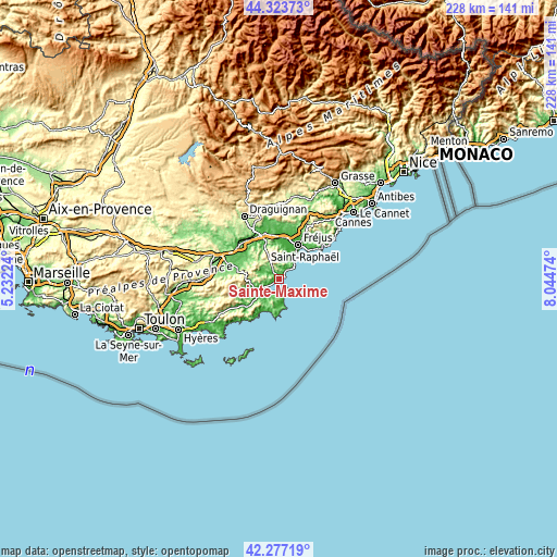
| \ | Map #1 | Map #2 | Topo.Map |
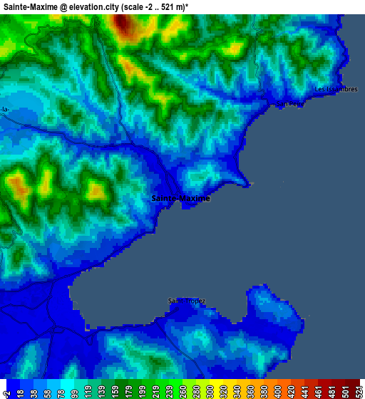
| Scale [m] | -2..349 m | -2..521 m | × |
| Scale [ft] | -7..1145 ft | -7..1709 ft | × |
| Average | 70.8 m = 232 ft | 98.6 m = 323 ft | × |
| Width | 7.11 km = 4.4 mi | 14.22 km = 8.8 mi | 227.6 km = 141.4 mi |
| Height | 7.11 km = 4.4 mi | 14.22 km = 8.8 mi | 227.5 km = 141.4 mi |
| ↑Max Latitude | 43.341039° | 43.372991° | 44.32373° |
| Latitude at center | 43.30907° | 43.30907° | 43.30907° |
| ↓Min Latitude | 43.277084° | 43.245081° | 42.27719° |
| ← Min Longitude | 6.594545° | 6.550599° | 5.23224° |
| Longitude center | 6.63849° | 6.63849° | 6.63849° |
| →Max Longitude | 6.682435° | 6.726381° | 8.04474° |
Nearby cities:
Cities around Sainte-Maxime sort by population:
• Fréjus elevation 22 m
15.9 km,  29°
29°
• Saint-Raphaël 22 m
16.7 km,  40°
40°
• Roquebrune-sur-Argens 19 m
14.9 km,  359°
359°
• Cogolin 33 m
10.8 km,  234°
234°
• Puget-sur-Argens 28 m
16.7 km,  13°
13°
• Saint-Tropez 19 m
4.6 km,  177°
177°
• Grimaud 49 m
10.3 km,  247°
247°
• La Croix-Valmer 121 m
12.7 km,  206°
206°
• Gassin 182 m
9.9 km, 205°
• Le Plan-de-la-Tour 66 m
7.6 km,  290°
290°
• Ramatuelle 55 m
10.6 km,  191°
191°
• La Garde-Freinet 351 m
13.7 km,  273°
273°
Multilingual:
 En español:
Sainte-Maxime elevación 8 m.
 En France:
Sainte-Maxime élévation 8 m.
 Auf Deutsch:
Sainte-Maxime höhe über dem Meeresspiegel ist 8 m.

Sources and notes:
- [note 1] Map square and city borders are not equal. Map elevation data is calculated only from area inside that square.
- [src 1] Elevation data from geonames database provided with same terms of usage.
- [src 2] The elevation map of Sainte-Maxime is generated using elevation data from NASA's 3 arcsec (90m) resolution SRTM data.
- [src 3] Base (background) map © OpenStreetMap contributors tiles are generated by Geofabrik and OpenTopoMap.
Copyright & License:
This Sainte-Maxime Elevation Map is licensed under CC BY-SA. You may reuse any part from this page, if you give a proper credit by linking to this URL:
 More info on terms of use page.