Saint-Étienne-au-Mont elevation
Saint-Étienne-au-Mont (Hauts-de-France, Pas-de-Calais), France elevation is 13 meters and Saint-Étienne-au-Mont elevation in feet is 43 ft above sea level [src 1]. Saint-Étienne-au-Mont is a populated place (feature code) with elevation that is 161 meters (528 ft) smaller than average city elevation in France.
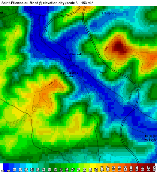
Below is the Elevation map of Saint-Étienne-au-Mont, which displays elevation range with different colors. Scale of the first map is from 3 to 153 m (10 to 502 ft) with average elevation of 52.4 meters (=172 ft) [note 1]
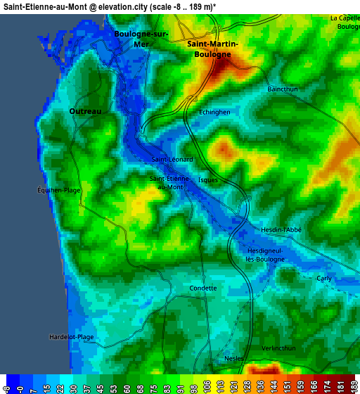
These maps also provides idea of topography and contour of this city, they are displayed at different zoom levels. More info about maps, scale and edge coordinates you can find below images.
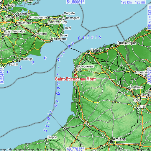
| \ | Map #1 | Map #2 | Topo.Map |
| Scale [m] | 3..153 m | -8..189 m | × |
| Scale [ft] | 10..502 ft | -26..620 ft | × |
| Average | 52.4 m = 172 ft | 56 m = 184 ft | × |
| Width | 6.19 km = 3.8 mi | 12.39 km = 7.7 mi | 198.2 km = 123.2 mi |
| Height | 6.19 km = 3.8 mi | 12.39 km = 7.7 mi | 198.2 km = 123.2 mi |
| ↑Max Latitude | 50.705779° | 50.733601° | 51.56061° |
| Latitude at center | 50.67794° | 50.67794° | 50.67794° |
| ↓Min Latitude | 50.650085° | 50.622213° | 49.77835° |
| ← Min Longitude | 1.586895° | 1.542949° | 0.22459° |
| Longitude center | 1.63084° | 1.63084° | 1.63084° |
| →Max Longitude | 1.674785° | 1.718731° | 3.03709° |
Nearby cities:
Cities around Saint-Étienne-au-Mont sort by population:
• Boulogne-sur-Mer elevation 75 m
5.4 km,  347°
347°
• Outreau 59 m
4.2 km,  316°
316°
• Saint-Martin-Boulogne 63 m
5.5 km, 351°
• Le Portel 28 m
5 km,  308°
308°
• Saint-Léonard 10 m
1.5 km,  344°
344°
• Neufchâtel-Hardelot 49 m
6.5 km,  172°
172°
• Équihen-Plage 70 m
4.1 km,  266°
266°
• Condette 73 m
2.2 km, 174°
• La Capelle-lès-Boulogne 110 m
7.9 km,  39°
39°
• Baincthun 34 m
5 km, 44°
• Isques 30 m
1.7 km,  105°
105°
• Nesles 42 m
6.1 km,  162°
162°
Multilingual:
 En español:
Saint-Étienne-au-Mont elevación 13 m.
 En France:
Saint-Étienne-au-Mont élévation 13 m.
 Auf Deutsch:
Saint-Étienne-au-Mont höhe über dem Meeresspiegel ist 13 m.

Sources and notes:
- [note 1] Map square and city borders are not equal. Map elevation data is calculated only from area inside that square.
- [src 1] Elevation data from geonames database provided with same terms of usage.
- [src 2] The elevation map of Saint-Étienne-au-Mont is generated using elevation data from NASA's 3 arcsec (90m) resolution SRTM data.
- [src 3] Base (background) map © OpenStreetMap contributors tiles are generated by Geofabrik and OpenTopoMap.
Copyright & License:
This Saint-Étienne-au-Mont Elevation Map is licensed under CC BY-SA. You may reuse any part from this page, if you give a proper credit by linking to this URL:
 More info on terms of use page.