Saint-Gély-du-Fesc elevation
Saint-Gély-du-Fesc (Occitanie, Département de l'Hérault), France elevation is 121 meters and Saint-Gély-du-Fesc elevation in feet is 397 ft above sea level [src 1]. Saint-Gély-du-Fesc is a populated place (feature code) with elevation that is 53 meters (174 ft) smaller than average city elevation in France.
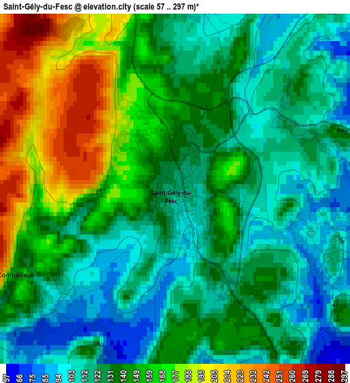
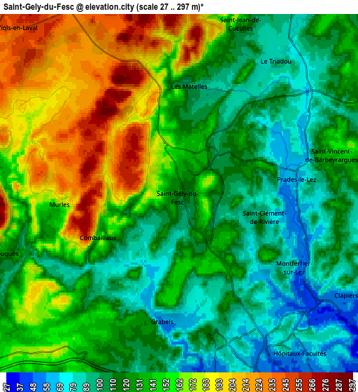
Below is the Elevation map of Saint-Gély-du-Fesc, which displays elevation range with different colors. Scale of the first map is from 57 to 297 m (187 to 974 ft) with average elevation of 138.6 meters (=455 ft) [note 1]
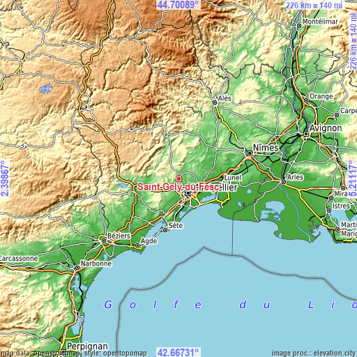
These maps also provides idea of topography and contour of this city, they are displayed at different zoom levels. More info about maps, scale and edge coordinates you can find below images.
| \ | Map #1 | Map #2 | Topo.Map |
| Scale [m] | 57..297 m | 27..297 m | × |
| Scale [ft] | 187..974 ft | 89..974 ft | × |
| Average | 138.6 m = 455 ft | 136.4 m = 448 ft | × |
| Width | 7.07 km = 4.4 mi | 14.13 km = 8.8 mi | 226.1 km = 140.5 mi |
| Height | 7.07 km = 4.4 mi | 14.13 km = 8.8 mi | 226.1 km = 140.5 mi |
| ↑Max Latitude | 43.724486° | 43.756236° | 44.70089° |
| Latitude at center | 43.69272° | 43.69272° | 43.69272° |
| ↓Min Latitude | 43.660937° | 43.629137° | 42.66731° |
| ← Min Longitude | 3.760975° | 3.717029° | 2.39867° |
| Longitude center | 3.80492° | 3.80492° | 3.80492° |
| →Max Longitude | 3.848865° | 3.892811° | 5.21117° |
Nearby cities:
Cities around Saint-Gély-du-Fesc sort by population:
• Juvignac elevation 54 m
8.8 km,  177°
177°
• Grabels 66 m
5 km,  185°
185°
• Clapiers 82 m
7.8 km,  119°
119°
• Saint-Clément-de-Rivière 90 m
2.5 km,  114°
114°
• Jacou 64 m
9.3 km, 111°
• Prades-le-Lez 69 m
4.8 km,  83°
83°
• Saint-Mathieu-de-Tréviers 125 m
9.4 km,  27°
27°
• Montferrier-sur-Lez 84 m
4.9 km,  125°
125°
• Vailhauquès 130 m
7.2 km,  250°
250°
• Les Matelles 99 m
4.1 km,  9°
9°
• Assas 116 m
7.7 km, 81°
• Combaillaux 143 m
3.8 km,  232°
232°
Multilingual:
 En español:
Saint-Gély-du-Fesc elevación 121 m.
 En France:
Saint-Gély-du-Fesc élévation 121 m.
 Auf Deutsch:
Saint-Gély-du-Fesc höhe über dem Meeresspiegel ist 121 m.
 На русском:
Saint-Gély-du-Fesc высота над уровнем моря 121 м
Sources and notes:
- [note 1] Map square and city borders are not equal. Map elevation data is calculated only from area inside that square.
- [src 1] Elevation data from geonames database provided with same terms of usage.
- [src 2] The elevation map of Saint-Gély-du-Fesc is generated using elevation data from NASA's 3 arcsec (90m) resolution SRTM data.
- [src 3] Base (background) map © OpenStreetMap contributors tiles are generated by Geofabrik and OpenTopoMap.
Copyright & License:
This Saint-Gély-du-Fesc Elevation Map is licensed under CC BY-SA. You may reuse any part from this page, if you give a proper credit by linking to this URL:
 More info on terms of use page.