Saint-Gervais-les-Bains elevation
Saint-Gervais-les-Bains (Auvergne-Rhône-Alpes, Haute-Savoie), France elevation is 1401 meters and Saint-Gervais-les-Bains elevation in feet is 4596 ft above sea level [src 1]. Saint-Gervais-les-Bains is a populated place (feature code) with elevation that is 1227 meters (4026 ft) bigger than average city elevation in France.
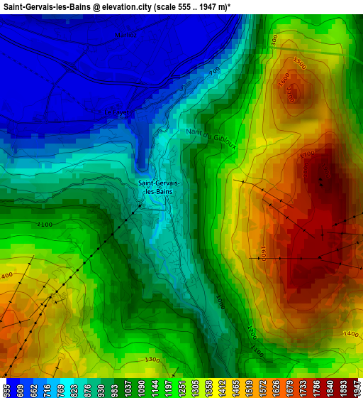
Below is the Elevation map of Saint-Gervais-les-Bains, which displays elevation range with different colors. Scale of the first map is from 555 to 1947 m (1821 to 6388 ft) with average elevation of 1126.5 meters (=3696 ft) [note 1]
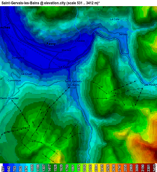
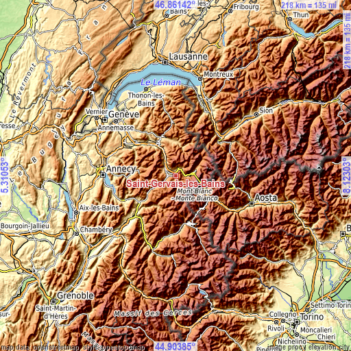
These maps also provides idea of topography and contour of this city, they are displayed at different zoom levels. More info about maps, scale and edge coordinates you can find below images.
| \ | Map #1 | Map #2 | Topo.Map |
| Scale [m] | 555..1947 m | 531..3412 m | × |
| Scale [ft] | 1821..6388 ft | 1742..11194 ft | × |
| Average | 1126.5 m = 3696 ft | 1272.9 m = 4176 ft | × |
| Width | 6.8 km = 4.2 mi | 13.6 km = 8.5 mi | 217.7 km = 135.3 mi |
| Height | 6.8 km = 4.2 mi | 13.6 km = 8.5 mi | 217.6 km = 135.2 mi |
| ↑Max Latitude | 45.921838° | 45.9524° | 46.86142° |
| Latitude at center | 45.89126° | 45.89126° | 45.89126° |
| ↓Min Latitude | 45.860665° | 45.830052° | 44.90385° |
| ← Min Longitude | 6.672835° | 6.628889° | 5.31053° |
| Longitude center | 6.71678° | 6.71678° | 6.71678° |
| →Max Longitude | 6.760725° | 6.804671° | 8.12303° |
Nearby cities:
Cities around Saint-Gervais-les-Bains sort by population:
• Sallanches elevation 542 m
8.8 km,  311°
311°
• Passy 582 m
3.9 km,  335°
335°
• Chamonix-Mont-Blanc 1044 m
12.3 km,  72°
72°
• Megève 1250 m
8.6 km,  243°
243°
• Les Houches 1010 m
6.9 km,  88°
88°
• Magland 1019 m
16.2 km,  332°
332°
• Combloux 916 m
5.7 km,  277°
277°
• Domancy 554 m
5.5 km,  294°
294°
• Arâches-la-Frasse 962 m
18.1 km, 338°
• Praz-sur-Arly 1012 m
12.7 km, 241°
• Les Contamines-Montjoie 1176 m
7.8 km,  173°
173°
• Cordon 872 m
9.2 km, 290°
Multilingual:
 En español:
Saint-Gervais-les-Bains elevación 1401 m.
 En France:
Saint-Gervais-les-Bains élévation 1401 m.
 Auf Deutsch:
Saint-Gervais-les-Bains höhe über dem Meeresspiegel ist 1401 m.

Sources and notes:
- [note 1] Map square and city borders are not equal. Map elevation data is calculated only from area inside that square.
- [src 1] Elevation data from geonames database provided with same terms of usage.
- [src 2] The elevation map of Saint-Gervais-les-Bains is generated using elevation data from NASA's 3 arcsec (90m) resolution SRTM data.
- [src 3] Base (background) map © OpenStreetMap contributors tiles are generated by Geofabrik and OpenTopoMap.
Copyright & License:
This Saint-Gervais-les-Bains Elevation Map is licensed under CC BY-SA. You may reuse any part from this page, if you give a proper credit by linking to this URL:
 More info on terms of use page.