Saint-Juéry elevation
Saint-Juéry (Occitanie, Tarn), France elevation is 211 meters and Saint-Juéry elevation in feet is 692 ft above sea level [src 1]. Saint-Juéry is a populated place (feature code) with elevation that is 37 meters (121 ft) bigger than average city elevation in France.
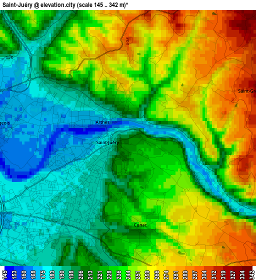
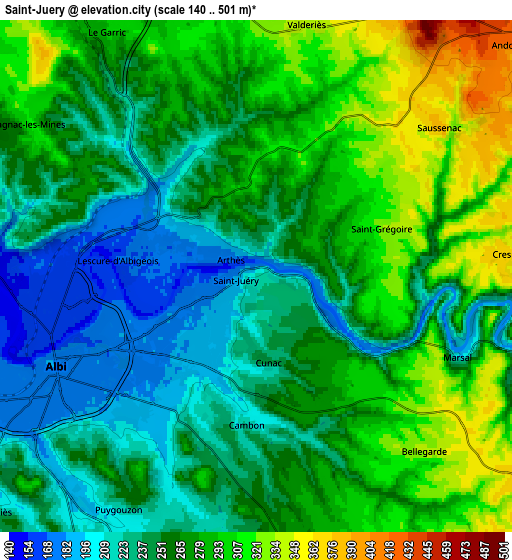
Below is the Elevation map of Saint-Juéry, which displays elevation range with different colors. Scale of the first map is from 145 to 342 m (476 to 1122 ft) with average elevation of 229.1 meters (=752 ft) [note 1]
These maps also provides idea of topography and contour of this city, they are displayed at different zoom levels. More info about maps, scale and edge coordinates you can find below images.
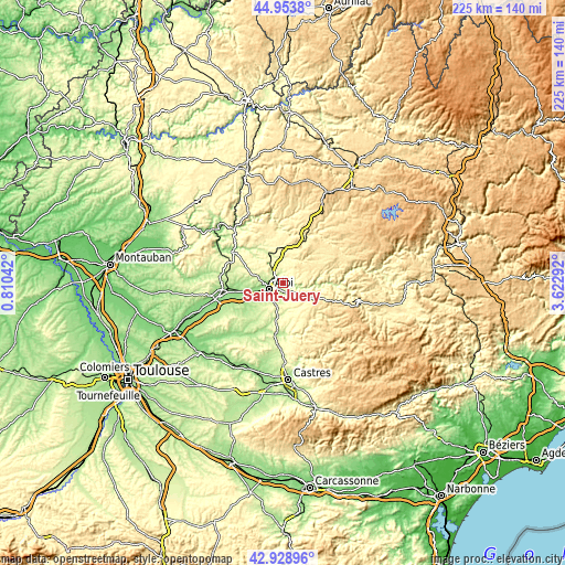
| \ | Map #1 | Map #2 | Topo.Map |
| Scale [m] | 145..342 m | 140..501 m | × |
| Scale [ft] | 476..1122 ft | 459..1644 ft | × |
| Average | 229.1 m = 752 ft | 263 m = 863 ft | × |
| Width | 7.04 km = 4.4 mi | 14.07 km = 8.7 mi | 225.1 km = 139.9 mi |
| Height | 7.04 km = 4.4 mi | 14.07 km = 8.7 mi | 225.1 km = 139.9 mi |
| ↑Max Latitude | 43.98163° | 44.013243° | 44.9538° |
| Latitude at center | 43.95° | 43.95° | 43.95° |
| ↓Min Latitude | 43.918353° | 43.88669° | 42.92896° |
| ← Min Longitude | 2.172725° | 2.128779° | 0.81042° |
| Longitude center | 2.21667° | 2.21667° | 2.21667° |
| →Max Longitude | 2.260615° | 2.304561° | 3.62292° |
Nearby cities:
Cities around Saint-Juéry sort by population:
• Albi elevation 177 m
5.9 km,  247°
247°
• Carmaux 245 m
12.2 km,  337°
337°
• Blaye-les-Mines 342 m
11.3 km,  322°
322°
• Puygouzon 284 m
6.9 km,  215°
215°
• Arthès 210 m
0.9 km,  332°
332°
• Cagnac-les-Mines 312 m
7.1 km,  302°
302°
• Castelnau-de-Lévis 204 m
10.6 km,  263°
263°
• Le Sequestre 174 m
9 km,  241°
241°
• Cunac 245 m
2.2 km,  175°
175°
• Le Garric 292 m
7.8 km, 327°
• Fréjairolles 283 m
7.8 km,  171°
171°
• Villefranche-d'Albigeois 421 m
10.9 km,  123°
123°
Multilingual:
 En español:
Saint-Juéry elevación 211 m.
 En France:
Saint-Juéry élévation 211 m.
 Auf Deutsch:
Saint-Juéry höhe über dem Meeresspiegel ist 211 m.

Sources and notes:
- [note 1] Map square and city borders are not equal. Map elevation data is calculated only from area inside that square.
- [src 1] Elevation data from geonames database provided with same terms of usage.
- [src 2] The elevation map of Saint-Juéry is generated using elevation data from NASA's 3 arcsec (90m) resolution SRTM data.
- [src 3] Base (background) map © OpenStreetMap contributors tiles are generated by Geofabrik and OpenTopoMap.
Copyright & License:
This Saint-Juéry Elevation Map is licensed under CC BY-SA. You may reuse any part from this page, if you give a proper credit by linking to this URL:
 More info on terms of use page.