Saint-Lambert-du-Lattay elevation
Saint-Lambert-du-Lattay (Pays de la Loire, Département de Maine-et-Loire), France elevation is 62 meters and Saint-Lambert-du-Lattay elevation in feet is 203 ft above sea level [src 1]. Saint-Lambert-du-Lattay is a populated place (feature code) with elevation that is 112 meters (367 ft) smaller than average city elevation in France.
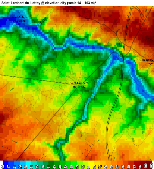
Below is the Elevation map of Saint-Lambert-du-Lattay, which displays elevation range with different colors. Scale of the first map is from 14 to 103 m (46 to 338 ft) with average elevation of 63.3 meters (=208 ft) [note 1]
These maps also provides idea of topography and contour of this city, they are displayed at different zoom levels. More info about maps, scale and edge coordinates you can find below images.
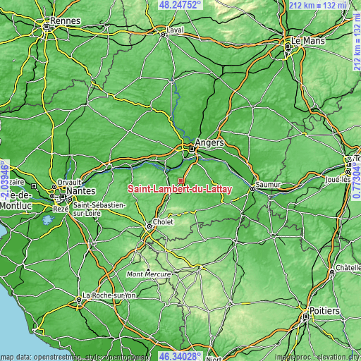
| \ | Map #1 | Topo.Map |
| Scale [m] | 14..103 m | × |
| Scale [ft] | 46..338 ft | × |
| Average | 63.3 m = 208 ft | × |
| Width | 6.63 km = 4.1 mi | 212.1 km = 131.8 mi |
| Height | 6.63 km = 4.1 mi | 212.1 km = 131.8 mi |
| ↑Max Latitude | 47.332292° | 48.24752° |
| Latitude at center | 47.3025° | 47.3025° |
| ↓Min Latitude | 47.272691° | 46.34028° |
| ← Min Longitude | -0.677155° | -2.03946° |
| Longitude center | -0.63321° | -0.63321° |
| →Max Longitude | -0.589265° | 0.77304° |
Nearby cities:
Cities around Saint-Lambert-du-Lattay sort by population:
• Chemillé-Melay elevation 86 m
12 km,  215°
215°
• Chalonnes-sur-Loire 25 m
11.2 km,  299°
299°
• La Possonnière 37 m
9 km,  333°
333°
• Mozé-sur-Louet 64 m
8.7 km,  44°
44°
• Rochefort-sur-Loire 27 m
6.3 km,  343°
343°
• Thouarcé 34 m
10.7 km,  111°
111°
• Vauchrétien 69 m
12.2 km,  74°
74°
• Denée 38 m
8.7 km,  12°
12°
• Soulaines-sur-Aubance 52 m
10.8 km,  50°
50°
• Savennières 25 m
9 km,  348°
348°
• Beaulieu-sur-Layon 88 m
3.4 km, 73°
• La Jumellière 88 m
7.7 km,  250°
250°
Multilingual:
 En español:
Saint-Lambert-du-Lattay elevación 62 m.
 En France:
Saint-Lambert-du-Lattay élévation 62 m.
 Auf Deutsch:
Saint-Lambert-du-Lattay höhe über dem Meeresspiegel ist 62 m.
 На русском:
Saint-Lambert-du-Lattay высота над уровнем моря 62 м
Sources and notes:
- [note 1] Map square and city borders are not equal. Map elevation data is calculated only from area inside that square.
- [src 1] Elevation data from geonames database provided with same terms of usage.
- [src 2] The elevation map of Saint-Lambert-du-Lattay is generated using elevation data from NASA's 3 arcsec (90m) resolution SRTM data.
- [src 3] Base (background) map © OpenStreetMap contributors tiles are generated by Geofabrik and OpenTopoMap.
Copyright & License:
This Saint-Lambert-du-Lattay Elevation Map is licensed under CC BY-SA. You may reuse any part from this page, if you give a proper credit by linking to this URL:
 More info on terms of use page.