Saint-Léonard-de-Noblat elevation
Saint-Léonard-de-Noblat (Nouvelle-Aquitaine, Haute-Vienne), France elevation is 346 meters and Saint-Léonard-de-Noblat elevation in feet is 1135 ft above sea level [src 1]. Saint-Léonard-de-Noblat is a populated place (feature code) with elevation that is 172 meters (564 ft) bigger than average city elevation in France.
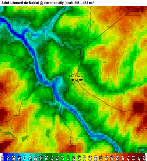
Below is the Elevation map of Saint-Léonard-de-Noblat, which displays elevation range with different colors. Scale of the first map is from 248 to 433 m (814 to 1421 ft) with average elevation of 342.3 meters (=1123 ft) [note 1]
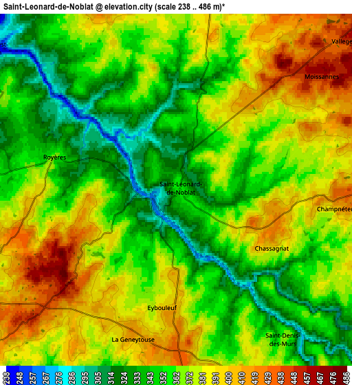
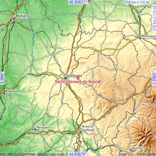
These maps also provides idea of topography and contour of this city, they are displayed at different zoom levels. More info about maps, scale and edge coordinates you can find below images.
| \ | Map #1 | Map #2 | Topo.Map |
| Scale [m] | 248..433 m | 238..486 m | × |
| Scale [ft] | 814..1421 ft | 781..1594 ft | × |
| Average | 342.3 m = 1123 ft | 367.1 m = 1204 ft | × |
| Width | 6.81 km = 4.2 mi | 13.62 km = 8.5 mi | 217.9 km = 135.4 mi |
| Height | 6.81 km = 4.2 mi | 13.62 km = 8.5 mi | 217.9 km = 135.4 mi |
| ↑Max Latitude | 45.867708° | 45.8983° | 46.80821° |
| Latitude at center | 45.8371° | 45.8371° | 45.8371° |
| ↓Min Latitude | 45.806475° | 45.775833° | 44.84874° |
| ← Min Longitude | 1.446305° | 1.402359° | 0.084° |
| Longitude center | 1.49025° | 1.49025° | 1.49025° |
| →Max Longitude | 1.534195° | 1.578141° | 2.8965° |
Nearby cities:
Cities around Saint-Léonard-de-Noblat sort by population:
• Panazol elevation 308 m
14 km,  270°
270°
• Le Palais-sur-Vienne 274 m
13.3 km,  282°
282°
• Feytiat 341 m
12.7 km,  256°
256°
• Ambazac 361 m
15.1 km,  332°
332°
• Rilhac-Rancon 285 m
15 km,  296°
296°
• Saint-Priest-Taurion 250 m
8.9 km,  308°
308°
• Boisseuil 370 m
14.4 km,  238°
238°
• Saint-Just-le-Martel 313 m
8.5 km,  289°
289°
• Saint-Paul 318 m
10.6 km,  205°
205°
• Linards 412 m
15.4 km,  168°
168°
• Sauviat-sur-Vige 409 m
11.9 km,  49°
49°
• Neuvic-Entier 411 m
15.8 km,  143°
143°
Multilingual:
 En español:
Saint-Léonard-de-Noblat elevación 346 m.
 En France:
Saint-Léonard-de-Noblat élévation 346 m.
 Auf Deutsch:
Saint-Léonard-de-Noblat höhe über dem Meeresspiegel ist 346 m.
 На русском:
Saint-Léonard-de-Noblat высота над уровнем моря 346 м
Sources and notes:
- [note 1] Map square and city borders are not equal. Map elevation data is calculated only from area inside that square.
- [src 1] Elevation data from geonames database provided with same terms of usage.
- [src 2] The elevation map of Saint-Léonard-de-Noblat is generated using elevation data from NASA's 3 arcsec (90m) resolution SRTM data.
- [src 3] Base (background) map © OpenStreetMap contributors tiles are generated by Geofabrik and OpenTopoMap.
Copyright & License:
This Saint-Léonard-de-Noblat Elevation Map is licensed under CC BY-SA. You may reuse any part from this page, if you give a proper credit by linking to this URL:
 More info on terms of use page.