Saint-Mammès elevation
Saint-Mammès (Île-de-France, Seine-et-Marne), France elevation is 58 meters and Saint-Mammès elevation in feet is 190 ft above sea level [src 1]. Saint-Mammès is a populated place (feature code) with elevation that is 116 meters (381 ft) smaller than average city elevation in France.
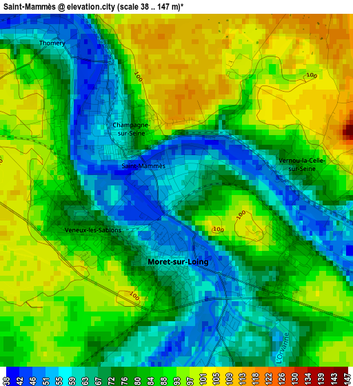
Below is the Elevation map of Saint-Mammès, which displays elevation range with different colors. Scale of the first map is from 38 to 147 m (125 to 482 ft) with average elevation of 81.1 meters (=266 ft) [note 1]
These maps also provides idea of topography and contour of this city, they are displayed at different zoom levels. More info about maps, scale and edge coordinates you can find below images.
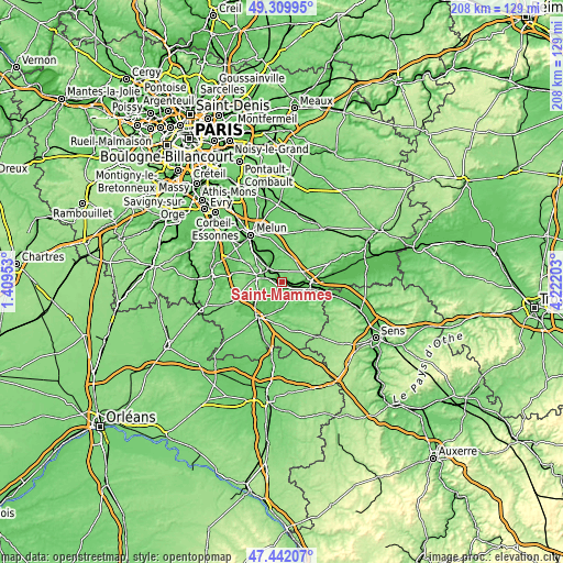
| \ | Map #1 | Topo.Map |
| Scale [m] | 38..147 m | × |
| Scale [ft] | 125..482 ft | × |
| Average | 81.1 m = 266 ft | × |
| Width | 6.49 km = 4 mi | 207.7 km = 129.1 mi |
| Height | 6.49 km = 4 mi | 207.7 km = 129.1 mi |
| ↑Max Latitude | 48.413757° | 49.30995° |
| Latitude at center | 48.38458° | 48.38458° |
| ↓Min Latitude | 48.355386° | 47.44207° |
| ← Min Longitude | 2.771835° | 1.40953° |
| Longitude center | 2.81578° | 2.81578° |
| →Max Longitude | 2.859725° | 4.22203° |
Nearby cities:
Cities around Saint-Mammès sort by population:
• Avon elevation 81 m
7.3 km,  285°
285°
• Champagne-sur-Seine 52 m
2 km,  318°
318°
• Veneux-les-Sablons 78 m
1.7 km,  247°
247°
• Moret-sur-Loing 55 m
1.4 km,  175°
175°
• Thomery 54 m
3.2 km, 321°
• Héricy 51 m
8.1 km,  331°
331°
• Écuelles 52 m
3.2 km,  169°
169°
• Montigny-sur-Loing 68 m
7.6 km,  224°
224°
• Vernou-la-Celle-sur-Seine 76 m
2.3 km,  80°
80°
• La Grande-Paroisse 115 m
6.3 km,  87°
87°
• Samoreau 64 m
6.7 km, 318°
• Vulaines-sur-Seine 90 m
6.5 km, 324°
Multilingual:
 En español:
Saint-Mammès elevación 58 m.
 En France:
Saint-Mammès élévation 58 m.
 Auf Deutsch:
Saint-Mammès höhe über dem Meeresspiegel ist 58 m.

Sources and notes:
- [note 1] Map square and city borders are not equal. Map elevation data is calculated only from area inside that square.
- [src 1] Elevation data from geonames database provided with same terms of usage.
- [src 2] The elevation map of Saint-Mammès is generated using elevation data from NASA's 3 arcsec (90m) resolution SRTM data.
- [src 3] Base (background) map © OpenStreetMap contributors tiles are generated by Geofabrik and OpenTopoMap.
Copyright & License:
This Saint-Mammès Elevation Map is licensed under CC BY-SA. You may reuse any part from this page, if you give a proper credit by linking to this URL:
 More info on terms of use page.