Saint-Marcel elevation
Saint-Marcel (Centre, Département de l'Indre), France elevation is 146 meters and Saint-Marcel elevation in feet is 479 ft above sea level [src 1]. Saint-Marcel is a populated place (feature code) with elevation that is 28 meters (92 ft) smaller than average city elevation in France.
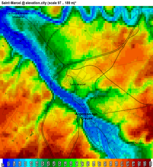
Below is the Elevation map of Saint-Marcel, which displays elevation range with different colors. Scale of the first map is from 97 to 189 m (318 to 620 ft) with average elevation of 144.4 meters (=474 ft) [note 1]
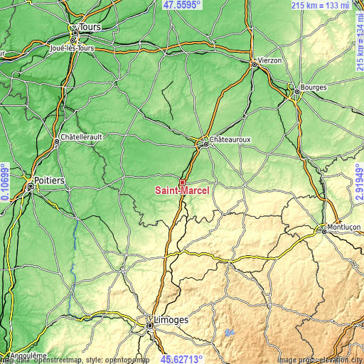
These maps also provides idea of topography and contour of this city, they are displayed at different zoom levels. More info about maps, scale and edge coordinates you can find below images.
| \ | Map #1 | Topo.Map |
| Scale [m] | 97..189 m | × |
| Scale [ft] | 318..620 ft | × |
| Average | 144.4 m = 474 ft | × |
| Width | 6.71 km = 4.2 mi | 214.9 km = 133.5 mi |
| Height | 6.71 km = 4.2 mi | 214.8 km = 133.5 mi |
| ↑Max Latitude | 46.632115° | 47.5595° |
| Latitude at center | 46.60193° | 46.60193° |
| ↓Min Latitude | 46.571728° | 45.62713° |
| ← Min Longitude | 1.469295° | 0.10699° |
| Longitude center | 1.51324° | 1.51324° |
| →Max Longitude | 1.557185° | 2.91949° |
Nearby cities:
Cities around Saint-Marcel sort by population:
• Argenton-sur-Creuse elevation 112 m
1.4 km,  159°
159°
• Le Poinçonnet 165 m
23.9 km,  40°
40°
• Saint-Maur 143 m
24.7 km,  22°
22°
• Saint-Gaultier 109 m
8.5 km,  295°
295°
• Le Pêchereau 122 m
3.8 km,  136°
136°
• Neuvy-Saint-Sépulchre 192 m
22.4 km,  91°
91°
• Chantôme 298 m
21.5 km,  171°
171°
• Éguzon-Chantôme 252 m
17.7 km, 162°
• Luant 143 m
15 km,  13°
13°
• Chaillac 186 m
24.9 km,  221°
221°
• Cluis 280 m
19.1 km,  109°
109°
• Arthon 139 m
17.4 km,  54°
54°
Multilingual:
 En español:
Saint-Marcel elevación 146 m.
 En France:
Saint-Marcel élévation 146 m.
 Auf Deutsch:
Saint-Marcel höhe über dem Meeresspiegel ist 146 m.

Sources and notes:
- [note 1] Map square and city borders are not equal. Map elevation data is calculated only from area inside that square.
- [src 1] Elevation data from geonames database provided with same terms of usage.
- [src 2] The elevation map of Saint-Marcel is generated using elevation data from NASA's 3 arcsec (90m) resolution SRTM data.
- [src 3] Base (background) map © OpenStreetMap contributors tiles are generated by Geofabrik and OpenTopoMap.
Copyright & License:
This Saint-Marcel Elevation Map is licensed under CC BY-SA. You may reuse any part from this page, if you give a proper credit by linking to this URL:
 More info on terms of use page.