Saint-Pardoux-Isaac elevation
Saint-Pardoux-Isaac (Nouvelle-Aquitaine, Département du Lot-et-Garonne), France elevation is 83 meters and Saint-Pardoux-Isaac elevation in feet is 272 ft above sea level [src 1]. Saint-Pardoux-Isaac is a populated place (feature code) with elevation that is 91 meters (299 ft) smaller than average city elevation in France.
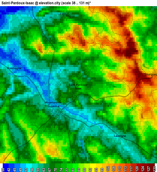
Below is the Elevation map of Saint-Pardoux-Isaac, which displays elevation range with different colors. Scale of the first map is from 38 to 131 m (125 to 430 ft) with average elevation of 76.9 meters (=252 ft) [note 1]
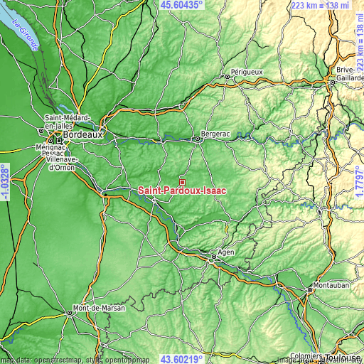
These maps also provides idea of topography and contour of this city, they are displayed at different zoom levels. More info about maps, scale and edge coordinates you can find below images.
| \ | Map #1 | Topo.Map |
| Scale [m] | 38..131 m | × |
| Scale [ft] | 125..430 ft | × |
| Average | 76.9 m = 252 ft | × |
| Width | 6.96 km = 4.3 mi | 222.6 km = 138.3 mi |
| Height | 6.96 km = 4.3 mi | 222.6 km = 138.3 mi |
| ↑Max Latitude | 44.643175° | 45.60435° |
| Latitude at center | 44.6119° | 44.6119° |
| ↓Min Latitude | 44.580608° | 43.60219° |
| ← Min Longitude | 0.329505° | -1.0328° |
| Longitude center | 0.37345° | 0.37345° |
| →Max Longitude | 0.417395° | 1.7797° |
Nearby cities:
Cities around Saint-Pardoux-Isaac sort by population:
• Marmande elevation 30 m
20.7 km,  233°
233°
• Miramont-de-Guyenne 59 m
1.4 km,  217°
217°
• Sainte-Bazeille 27 m
23.7 km,  247°
247°
• Eymet 53 m
6.6 km,  18°
18°
• Gontaud-de-Nogaret 61 m
18.9 km,  197°
197°
• Monségur 66 m
23.6 km,  280°
280°
• Virazeil 47 m
16.7 km, 225°
• Castillonnès 130 m
17.9 km,  75°
75°
• Cancon 166 m
21.7 km,  113°
113°
• Duras 107 m
16.7 km,  295°
295°
• Beaupuy 98 m
19.7 km,  244°
244°
• Monbazillac 172 m
22.3 km, 24°
Multilingual:
 En español:
Saint-Pardoux-Isaac elevación 83 m.
 En France:
Saint-Pardoux-Isaac élévation 83 m.
 Auf Deutsch:
Saint-Pardoux-Isaac höhe über dem Meeresspiegel ist 83 m.
 На русском:
Saint-Pardoux-Isaac высота над уровнем моря 83 м
Sources and notes:
- [note 1] Map square and city borders are not equal. Map elevation data is calculated only from area inside that square.
- [src 1] Elevation data from geonames database provided with same terms of usage.
- [src 2] The elevation map of Saint-Pardoux-Isaac is generated using elevation data from NASA's 3 arcsec (90m) resolution SRTM data.
- [src 3] Base (background) map © OpenStreetMap contributors tiles are generated by Geofabrik and OpenTopoMap.
Copyright & License:
This Saint-Pardoux-Isaac Elevation Map is licensed under CC BY-SA. You may reuse any part from this page, if you give a proper credit by linking to this URL:
 More info on terms of use page.