Saint-Paul-lès-Dax elevation
Saint-Paul-lès-Dax (Nouvelle-Aquitaine, Landes), France elevation is 21 meters and Saint-Paul-lès-Dax elevation in feet is 69 ft above sea level [src 1]. Saint-Paul-lès-Dax is a populated place (feature code) with elevation that is 153 meters (502 ft) smaller than average city elevation in France.
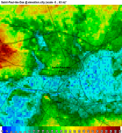
Below is the Elevation map of Saint-Paul-lès-Dax, which displays elevation range with different colors. Scale of the first map is from -5 to 63 m (-16 to 207 ft) with average elevation of 19.9 meters (=65 ft) [note 1]
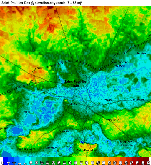
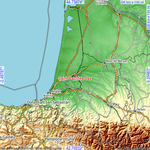
These maps also provides idea of topography and contour of this city, they are displayed at different zoom levels. More info about maps, scale and edge coordinates you can find below images.
| \ | Map #1 | Map #2 | Topo.Map |
| Scale [m] | -5..63 m | -7..83 m | × |
| Scale [ft] | -16..207 ft | -23..272 ft | × |
| Average | 19.9 m = 65 ft | 28.2 m = 93 ft | × |
| Width | 7.06 km = 4.4 mi | 14.12 km = 8.8 mi | 226 km = 140.4 mi |
| Height | 7.06 km = 4.4 mi | 14.12 km = 8.8 mi | 226 km = 140.4 mi |
| ↑Max Latitude | 43.758898° | 43.79063° | 44.73474° |
| Latitude at center | 43.72715° | 43.72715° | 43.72715° |
| ↓Min Latitude | 43.695385° | 43.663603° | 42.70232° |
| ← Min Longitude | -1.095565° | -1.139511° | -2.45787° |
| Longitude center | -1.05162° | -1.05162° | -1.05162° |
| →Max Longitude | -1.007675° | -0.963729° | 0.35463° |
Nearby cities:
Cities around Saint-Paul-lès-Dax sort by population:
• Dax elevation 16 m
1.9 km,  185°
185°
• Narrosse 14 m
4.4 km,  126°
126°
• Saint-Vincent-de-Paul 21 m
4.1 km,  62°
62°
• Pontonx-sur-l'Adour 27 m
12.2 km, 56°
• Oeyreluy 14 m
7 km,  201°
201°
• Mées 13 m
5.3 km,  241°
241°
• Saugnac-et-Cambran 14 m
7.7 km,  143°
143°
• Heugas 52 m
9.6 km, 194°
• Hinx 50 m
10.5 km,  105°
105°
• Tercis-les-Bains 33 m
7.7 km,  215°
215°
• Mimbaste 17 m
10.7 km, 144°
• Rivière-Saas-et-Gourby 22 m
9.5 km, 236°
Multilingual:
 En español:
Saint-Paul-lès-Dax elevación 21 m.
 En France:
Saint-Paul-lès-Dax élévation 21 m.
 Auf Deutsch:
Saint-Paul-lès-Dax höhe über dem Meeresspiegel ist 21 m.

Sources and notes:
- [note 1] Map square and city borders are not equal. Map elevation data is calculated only from area inside that square.
- [src 1] Elevation data from geonames database provided with same terms of usage.
- [src 2] The elevation map of Saint-Paul-lès-Dax is generated using elevation data from NASA's 3 arcsec (90m) resolution SRTM data.
- [src 3] Base (background) map © OpenStreetMap contributors tiles are generated by Geofabrik and OpenTopoMap.
Copyright & License:
This Saint-Paul-lès-Dax Elevation Map is licensed under CC BY-SA. You may reuse any part from this page, if you give a proper credit by linking to this URL:
 More info on terms of use page.