Saint-Quentin-Fallavier elevation
Saint-Quentin-Fallavier (Auvergne-Rhône-Alpes, Département de l'Isère), France elevation is 225 meters and Saint-Quentin-Fallavier elevation in feet is 738 ft above sea level [src 1]. Saint-Quentin-Fallavier is a populated place (feature code) with elevation that is 51 meters (167 ft) bigger than average city elevation in France.
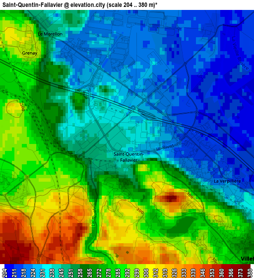
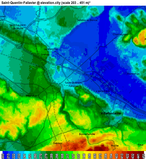
Below is the Elevation map of Saint-Quentin-Fallavier, which displays elevation range with different colors. Scale of the first map is from 204 to 380 m (669 to 1247 ft) with average elevation of 260.5 meters (=855 ft) [note 1]
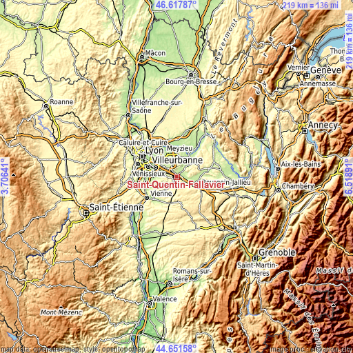
These maps also provides idea of topography and contour of this city, they are displayed at different zoom levels. More info about maps, scale and edge coordinates you can find below images.
| \ | Map #1 | Map #2 | Topo.Map |
| Scale [m] | 204..380 m | 203..451 m | × |
| Scale [ft] | 669..1247 ft | 666..1480 ft | × |
| Average | 260.5 m = 855 ft | 273.6 m = 898 ft | × |
| Width | 6.83 km = 4.2 mi | 13.66 km = 8.5 mi | 218.6 km = 135.8 mi |
| Height | 6.83 km = 4.2 mi | 13.66 km = 8.5 mi | 218.6 km = 135.8 mi |
| ↑Max Latitude | 45.674065° | 45.704763° | 46.61787° |
| Latitude at center | 45.64335° | 45.64335° | 45.64335° |
| ↓Min Latitude | 45.612618° | 45.58187° | 44.65158° |
| ← Min Longitude | 5.068715° | 5.024769° | 3.70641° |
| Longitude center | 5.11266° | 5.11266° | 5.11266° |
| →Max Longitude | 5.156605° | 5.200551° | 6.51891° |
Nearby cities:
Cities around Saint-Quentin-Fallavier sort by population:
• Villefontaine elevation 262 m
4.5 km,  139°
139°
• La Verpillière 210 m
2.8 km,  111°
111°
• Saint-Laurent-de-Mure 241 m
7.1 km,  311°
311°
• Heyrieux 290 m
4.1 km,  251°
251°
• Diémoz 388 m
6.1 km,  197°
197°
• Vaulx-Milieu 219 m
6.5 km,  121°
121°
• Frontonas 309 m
6.6 km,  88°
88°
• Satolas-et-Bonce 233 m
5.8 km,  13°
13°
• Roche 350 m
7.3 km,  148°
148°
• Grenay 300 m
3.4 km, 311°
• Chamagnieu 294 m
6.2 km,  45°
45°
• Bonnefamille 330 m
5 km,  168°
168°
Multilingual:
 En español:
Saint-Quentin-Fallavier elevación 225 m.
 En France:
Fallavier élévation 225 m.
 Auf Deutsch:
Saint-Quentin-Fallavier höhe über dem Meeresspiegel ist 225 m.
 На русском:
Сен-Кантен-Фаллавье высота над уровнем моря 225 м
Sources and notes:
- [note 1] Map square and city borders are not equal. Map elevation data is calculated only from area inside that square.
- [src 1] Elevation data from geonames database provided with same terms of usage.
- [src 2] The elevation map of Saint-Quentin-Fallavier is generated using elevation data from NASA's 3 arcsec (90m) resolution SRTM data.
- [src 3] Base (background) map © OpenStreetMap contributors tiles are generated by Geofabrik and OpenTopoMap.
Copyright & License:
This Saint-Quentin-Fallavier Elevation Map is licensed under CC BY-SA. You may reuse any part from this page, if you give a proper credit by linking to this URL:
 More info on terms of use page.