Saint-Sauvant elevation
Saint-Sauvant (Nouvelle-Aquitaine, Vienne), France elevation is 137 meters and Saint-Sauvant elevation in feet is 449 ft above sea level [src 1]. Saint-Sauvant is a populated place (feature code) with elevation that is 37 meters (121 ft) smaller than average city elevation in France.
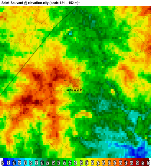
Below is the Elevation map of Saint-Sauvant, which displays elevation range with different colors. Scale of the first map is from 121 to 152 m (397 to 499 ft) with average elevation of 136.9 meters (=449 ft) [note 1]
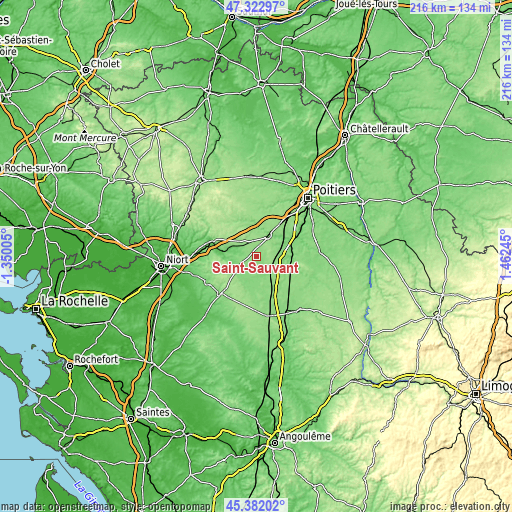
These maps also provides idea of topography and contour of this city, they are displayed at different zoom levels. More info about maps, scale and edge coordinates you can find below images.
| \ | Map #1 | Topo.Map |
| Scale [m] | 121..152 m | × |
| Scale [ft] | 397..499 ft | × |
| Average | 136.9 m = 449 ft | × |
| Width | 6.74 km = 4.2 mi | 215.8 km = 134.1 mi |
| Height | 6.74 km = 4.2 mi | 215.8 km = 134.1 mi |
| ↑Max Latitude | 46.391429° | 47.32297° |
| Latitude at center | 46.36111° | 46.36111° |
| ↓Min Latitude | 46.330774° | 45.38202° |
| ← Min Longitude | 0.012255° | -1.35005° |
| Longitude center | 0.0562° | 0.0562° |
| →Max Longitude | 0.100145° | 1.46245° |
Nearby cities:
Cities around Saint-Sauvant sort by population:
• Vivonne elevation 106 m
17.7 km,  64°
64°
• Lusignan 119 m
9.7 km,  31°
31°
• Rouillé 155 m
6.7 km,  349°
349°
• Lezay 131 m
11.8 km,  205°
205°
• Couhé 139 m
11.8 km,  125°
125°
• La Mothe-Saint-Héray 113 m
13 km,  269°
269°
• Pamproux 98 m
9.3 km,  294°
294°
• Nanteuil 77 m
18.6 km, 287°
• Exireuil 149 m
20.6 km, 292°
• Chaunay 133 m
19 km,  154°
154°
• Celle-Lévescault 123 m
12.2 km, 55°
• Coulombiers 148 m
17.2 km,  35°
35°
Multilingual:
 En español:
Saint-Sauvant elevación 137 m.
 En France:
Saint-Sauvant élévation 137 m.
 Auf Deutsch:
Saint-Sauvant höhe über dem Meeresspiegel ist 137 m.

Sources and notes:
- [note 1] Map square and city borders are not equal. Map elevation data is calculated only from area inside that square.
- [src 1] Elevation data from geonames database provided with same terms of usage.
- [src 2] The elevation map of Saint-Sauvant is generated using elevation data from NASA's 3 arcsec (90m) resolution SRTM data.
- [src 3] Base (background) map © OpenStreetMap contributors tiles are generated by Geofabrik and OpenTopoMap.
Copyright & License:
This Saint-Sauvant Elevation Map is licensed under CC BY-SA. You may reuse any part from this page, if you give a proper credit by linking to this URL:
 More info on terms of use page.