Saint-Sébastien-de-Morsent elevation
Saint-Sébastien-de-Morsent (Normandy, Département de l'Eure), France elevation is 126 meters and Saint-Sébastien-de-Morsent elevation in feet is 413 ft above sea level [src 1]. Saint-Sébastien-de-Morsent is a populated place (feature code) with elevation that is 48 meters (157 ft) smaller than average city elevation in France.
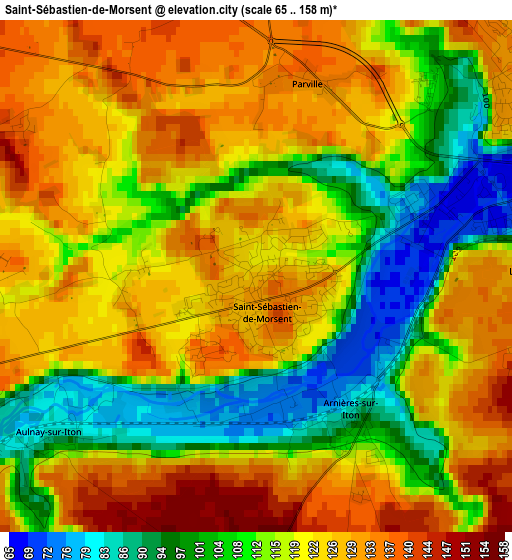
Below is the Elevation map of Saint-Sébastien-de-Morsent, which displays elevation range with different colors. Scale of the first map is from 65 to 158 m (213 to 518 ft) with average elevation of 117.7 meters (=386 ft) [note 1]
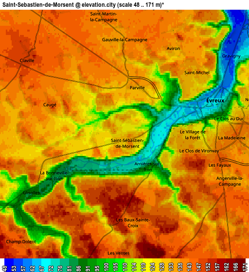
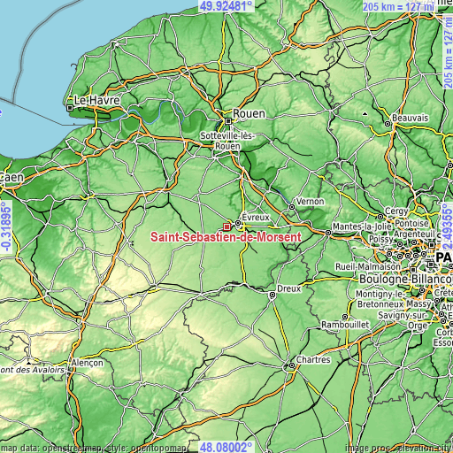
These maps also provides idea of topography and contour of this city, they are displayed at different zoom levels. More info about maps, scale and edge coordinates you can find below images.
| \ | Map #1 | Map #2 | Topo.Map |
| Scale [m] | 65..158 m | 48..171 m | × |
| Scale [ft] | 213..518 ft | 157..561 ft | × |
| Average | 117.7 m = 386 ft | 129.2 m = 424 ft | × |
| Width | 6.41 km = 4 mi | 12.82 km = 8 mi | 205.1 km = 127.4 mi |
| Height | 6.41 km = 4 mi | 12.82 km = 8 mi | 205.1 km = 127.4 mi |
| ↑Max Latitude | 49.039776° | 49.068575° | 49.92481° |
| Latitude at center | 49.01096° | 49.01096° | 49.01096° |
| ↓Min Latitude | 48.982127° | 48.953278° | 48.08002° |
| ← Min Longitude | 1.043355° | 0.999409° | -0.31895° |
| Longitude center | 1.0873° | 1.0873° | 1.0873° |
| →Max Longitude | 1.131245° | 1.175191° | 2.49355° |
Nearby cities:
Cities around Saint-Sébastien-de-Morsent sort by population:
• Évreux elevation 71 m
4.9 km,  72°
72°
• Conches-en-Ouche 152 m
12.2 km,  241°
241°
• Gravigny 61 m
7.6 km,  52°
52°
• Guichainville 135 m
7.8 km,  97°
97°
• La Bonneville-sur-Iton 138 m
4.1 km,  252°
252°
• Damville 142 m
15.8 km,  183°
183°
• Arnières-sur-Iton 84 m
2 km,  142°
142°
• Acquigny 19 m
19.2 km,  19°
19°
• Normanville 51 m
9.2 km,  34°
34°
• Aviron 138 m
4.8 km, 26°
• Heudreville-sur-Eure 20 m
16.2 km, 26°
• Claville 151 m
6.5 km,  310°
310°
Multilingual:
 En español:
Saint-Sébastien-de-Morsent elevación 126 m.
 En France:
Saint-Sébastien-de-Morsent élévation 126 m.
 Auf Deutsch:
Saint-Sébastien-de-Morsent höhe über dem Meeresspiegel ist 126 m.
 На русском:
Saint-Sébastien-de-Morsent высота над уровнем моря 126 м
Sources and notes:
- [note 1] Map square and city borders are not equal. Map elevation data is calculated only from area inside that square.
- [src 1] Elevation data from geonames database provided with same terms of usage.
- [src 2] The elevation map of Saint-Sébastien-de-Morsent is generated using elevation data from NASA's 3 arcsec (90m) resolution SRTM data.
- [src 3] Base (background) map © OpenStreetMap contributors tiles are generated by Geofabrik and OpenTopoMap.
Copyright & License:
This Saint-Sébastien-de-Morsent Elevation Map is licensed under CC BY-SA. You may reuse any part from this page, if you give a proper credit by linking to this URL:
 More info on terms of use page.