Saint-Sulpice-et-Cameyrac elevation
Saint-Sulpice-et-Cameyrac (Nouvelle-Aquitaine, Gironde), France elevation is 17 meters and Saint-Sulpice-et-Cameyrac elevation in feet is 56 ft above sea level [src 1]. Saint-Sulpice-et-Cameyrac is a populated place (feature code) with elevation that is 157 meters (515 ft) smaller than average city elevation in France.
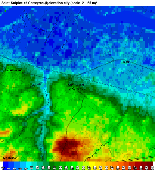
Below is the Elevation map of Saint-Sulpice-et-Cameyrac, which displays elevation range with different colors. Scale of the first map is from -2 to 65 m (-7 to 213 ft) with average elevation of 16.9 meters (=55 ft) [note 1]
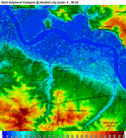
These maps also provides idea of topography and contour of this city, they are displayed at different zoom levels. More info about maps, scale and edge coordinates you can find below images.
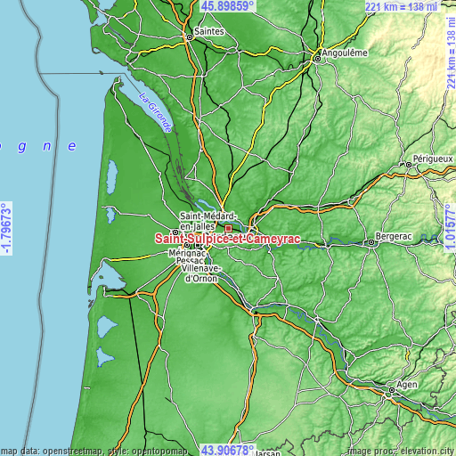
| \ | Map #1 | Map #2 | Topo.Map |
| Scale [m] | -2..65 m | -4..96 m | × |
| Scale [ft] | -7..213 ft | -13..315 ft | × |
| Average | 16.9 m = 55 ft | 26.6 m = 87 ft | × |
| Width | 6.92 km = 4.3 mi | 13.84 km = 8.6 mi | 221.5 km = 137.6 mi |
| Height | 6.92 km = 4.3 mi | 13.84 km = 8.6 mi | 221.5 km = 137.6 mi |
| ↑Max Latitude | 44.942424° | 44.97352° | 45.89859° |
| Latitude at center | 44.91131° | 44.91131° | 44.91131° |
| ↓Min Latitude | 44.880179° | 44.849032° | 43.90678° |
| ← Min Longitude | -0.434425° | -0.478371° | -1.79673° |
| Longitude center | -0.39048° | -0.39048° | -0.39048° |
| →Max Longitude | -0.346535° | -0.302589° | 1.01577° |
Nearby cities:
Cities around Saint-Sulpice-et-Cameyrac sort by population:
• Ambarès-et-Lagrave elevation 14 m
7.3 km,  274°
274°
• Saint-Loubès 25 m
2.9 km,  278°
278°
• Sainte-Eulalie 34 m
6.6 km, 265°
• Izon 6 m
2.6 km,  56°
56°
• Vayres 15 m
5.9 km,  102°
102°
• Pompignac 66 m
7.6 km,  208°
208°
• Montussan 29 m
4.2 km,  215°
215°
• Yvrac 70 m
6.5 km,  235°
235°
• La Lande-de-Fronsac 43 m
7.7 km,  5°
5°
• Beychac-et-Caillau 52 m
3.8 km,  193°
193°
• Saint-Vincent-de-Paul 3 m
7.7 km,  308°
308°
• Lugon-et-l'Île-du-Carnay 50 m
6.5 km,  41°
41°
Multilingual:
 En español:
Saint-Sulpice-et-Cameyrac elevación 17 m.
 En France:
Saint-Sulpice-et-Cameyrac élévation 17 m.
 Auf Deutsch:
Saint-Sulpice-et-Cameyrac höhe über dem Meeresspiegel ist 17 m.
 На русском:
Saint-Sulpice-et-Cameyrac высота над уровнем моря 17 м
Sources and notes:
- [note 1] Map square and city borders are not equal. Map elevation data is calculated only from area inside that square.
- [src 1] Elevation data from geonames database provided with same terms of usage.
- [src 2] The elevation map of Saint-Sulpice-et-Cameyrac is generated using elevation data from NASA's 3 arcsec (90m) resolution SRTM data.
- [src 3] Base (background) map © OpenStreetMap contributors tiles are generated by Geofabrik and OpenTopoMap.
Copyright & License:
This Saint-Sulpice-et-Cameyrac Elevation Map is licensed under CC BY-SA. You may reuse any part from this page, if you give a proper credit by linking to this URL:
 More info on terms of use page.