Saint-Vincent-de-Mercuze elevation
Saint-Vincent-de-Mercuze (Auvergne-Rhône-Alpes, Département de l'Isère), France elevation is 279 meters and Saint-Vincent-de-Mercuze elevation in feet is 915 ft above sea level [src 1]. Saint-Vincent-de-Mercuze is a populated place (feature code) with elevation that is 105 meters (344 ft) bigger than average city elevation in France.
Below is the Elevation map of Saint-Vincent-de-Mercuze, which displays elevation range with different colors. Scale of the first map is from 235 to 1807 m (771 to 5928 ft) with average elevation of 550.1 meters (=1805 ft) [note 1]
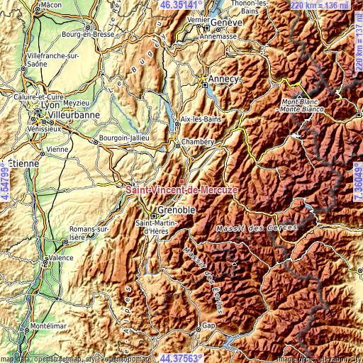
These maps also provides idea of topography and contour of this city, they are displayed at different zoom levels. More info about maps, scale and edge coordinates you can find below images.
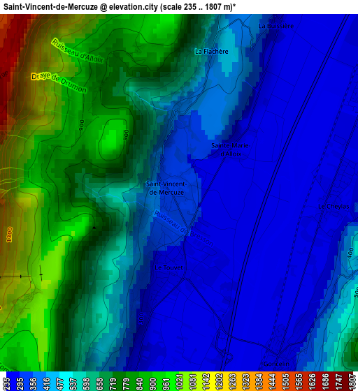
| \ | Map #1 | Topo.Map |
| Scale [m] | 235..1807 m | × |
| Scale [ft] | 771..5928 ft | × |
| Average | 550.1 m = 1805 ft | × |
| Width | 6.87 km = 4.3 mi | 219.7 km = 136.5 mi |
| Height | 6.87 km = 4.3 mi | 219.7 km = 136.5 mi |
| ↑Max Latitude | 45.403013° | 46.35141° |
| Latitude at center | 45.37215° | 45.37215° |
| ↓Min Latitude | 45.34127° | 44.37563° |
| ← Min Longitude | 5.910295° | 4.54799° |
| Longitude center | 5.95424° | 5.95424° |
| →Max Longitude | 5.998185° | 7.36049° |
Nearby cities:
Cities around Saint-Vincent-de-Mercuze sort by population:
• Pontcharra elevation 261 m
8.7 km,  35°
35°
• Allevard 466 m
9.8 km,  75°
75°
• Le Touvet 263 m
1.5 km,  184°
184°
• Le Cheylas 474 m
3 km,  93°
93°
• La Terrasse 240 m
6.1 km,  199°
199°
• Goncelin 277 m
3.7 km,  148°
148°
• Saint-Hilaire 1026 m
9.8 km,  214°
214°
• Theys 703 m
8.6 km,  156°
156°
• Lumbin 253 m
7.6 km, 203°
• Barraux 282 m
6.9 km,  16°
16°
• Le Champ-près-Froges 364 m
10.3 km,  186°
186°
• Tencin 245 m
6.8 km, 177°
Multilingual:
 En español:
Saint-Vincent-de-Mercuze elevación 279 m.
 En France:
Saint-Vincent-de-Mercuze élévation 279 m.
 Auf Deutsch:
Saint-Vincent-de-Mercuze höhe über dem Meeresspiegel ist 279 m.
 На русском:
Saint-Vincent-de-Mercuze высота над уровнем моря 279 м
Sources and notes:
- [note 1] Map square and city borders are not equal. Map elevation data is calculated only from area inside that square.
- [src 1] Elevation data from geonames database provided with same terms of usage.
- [src 2] The elevation map of Saint-Vincent-de-Mercuze is generated using elevation data from NASA's 3 arcsec (90m) resolution SRTM data.
- [src 3] Base (background) map © OpenStreetMap contributors tiles are generated by Geofabrik and OpenTopoMap.
Copyright & License:
This Saint-Vincent-de-Mercuze Elevation Map is licensed under CC BY-SA. You may reuse any part from this page, if you give a proper credit by linking to this URL:
 More info on terms of use page.