Sancoins elevation
Sancoins (Centre, Cher), France elevation is 199 meters and Sancoins elevation in feet is 653 ft above sea level [src 1]. Sancoins is a populated place (feature code) with elevation that is 25 meters (82 ft) bigger than average city elevation in France.
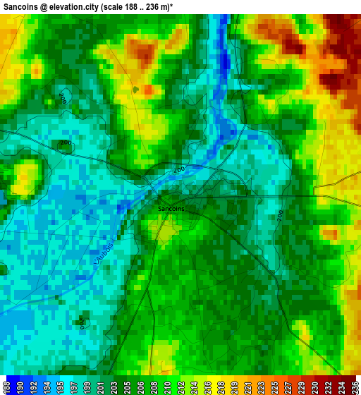
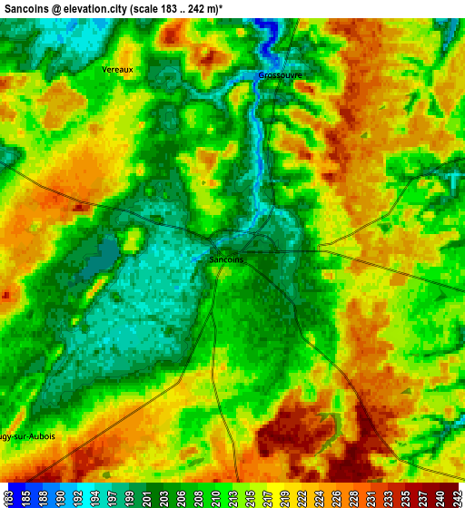
Below is the Elevation map of Sancoins, which displays elevation range with different colors. Scale of the first map is from 188 to 236 m (617 to 774 ft) with average elevation of 205.6 meters (=675 ft) [note 1]
These maps also provides idea of topography and contour of this city, they are displayed at different zoom levels. More info about maps, scale and edge coordinates you can find below images.
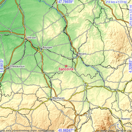
| \ | Map #1 | Map #2 | Topo.Map |
| Scale [m] | 188..236 m | 183..242 m | × |
| Scale [ft] | 617..774 ft | 600..794 ft | × |
| Average | 205.6 m = 675 ft | 212.9 m = 698 ft | × |
| Width | 6.69 km = 4.2 mi | 13.37 km = 8.3 mi | 213.9 km = 132.9 mi |
| Height | 6.69 km = 4.2 mi | 13.37 km = 8.3 mi | 213.9 km = 132.9 mi |
| ↑Max Latitude | 46.863196° | 46.893235° | 47.78659° |
| Latitude at center | 46.83314° | 46.83314° | 46.83314° |
| ↓Min Latitude | 46.803067° | 46.772978° | 45.86247° |
| ← Min Longitude | 2.878435° | 2.834489° | 1.51613° |
| Longitude center | 2.92238° | 2.92238° | 2.92238° |
| →Max Longitude | 2.966325° | 3.010271° | 4.32863° |
Nearby cities:
Cities around Sancoins sort by population:
• Marzy elevation 209 m
21 km,  38°
38°
• Lurcy-Lévis 220 m
11.6 km,  173°
173°
• Saint-Pierre-le-Moûtier 220 m
15.4 km,  106°
106°
• Challuy 199 m
21.5 km,  52°
52°
• Nérondes 191 m
19.9 km,  336°
336°
• Sermoise-sur-Loire 186 m
23.7 km,  56°
56°
• Magny-Cours 205 m
18.2 km,  72°
72°
• Saint-Parize-le-Châtel 234 m
19.9 km,  83°
83°
• Ainay-le-Château 216 m
22.1 km,  232°
232°
• Chantenay-Saint-Imbert 218 m
22.8 km,  119°
119°
• Cours-les-Barres 178 m
22.9 km,  21°
21°
• Cuffy 185 m
17.5 km,  34°
34°
Multilingual:
 En español:
Sancoins elevación 199 m.
 En France:
Sancoins élévation 199 m.
 Auf Deutsch:
Sancoins höhe über dem Meeresspiegel ist 199 m.

Sources and notes:
- [note 1] Map square and city borders are not equal. Map elevation data is calculated only from area inside that square.
- [src 1] Elevation data from geonames database provided with same terms of usage.
- [src 2] The elevation map of Sancoins is generated using elevation data from NASA's 3 arcsec (90m) resolution SRTM data.
- [src 3] Base (background) map © OpenStreetMap contributors tiles are generated by Geofabrik and OpenTopoMap.
Copyright & License:
This Sancoins Elevation Map is licensed under CC BY-SA. You may reuse any part from this page, if you give a proper credit by linking to this URL:
 More info on terms of use page.