Sannois elevation
Sannois (Île-de-France, Département du Val-d’Oise), France elevation is 107 meters and Sannois elevation in feet is 351 ft above sea level [src 1]. Sannois is a populated place (feature code) with elevation that is 67 meters (220 ft) smaller than average city elevation in France.
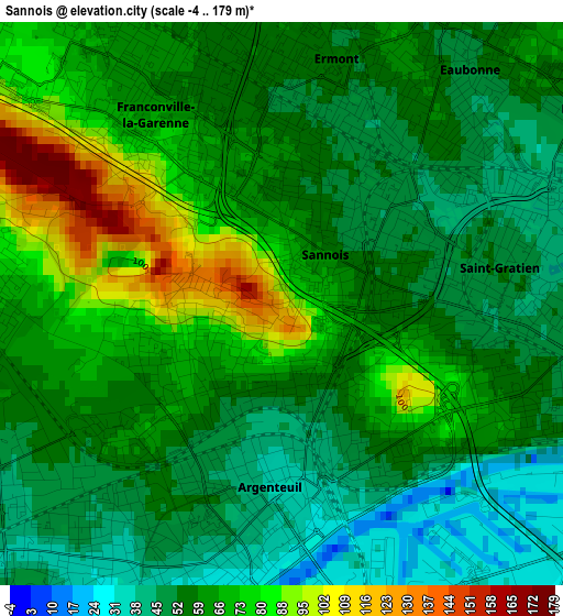
Below is the Elevation map of Sannois, which displays elevation range with different colors. Scale of the first map is from -4 to 179 m (-13 to 587 ft) with average elevation of 62.4 meters (=205 ft) [note 1]
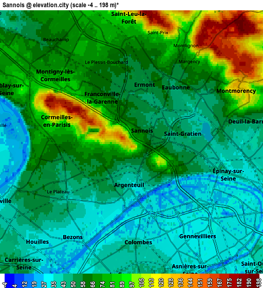
These maps also provides idea of topography and contour of this city, they are displayed at different zoom levels. More info about maps, scale and edge coordinates you can find below images.
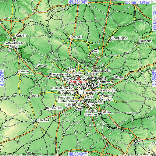
| \ | Map #1 | Map #2 | Topo.Map |
| Scale [m] | -4..179 m | -4..198 m | × |
| Scale [ft] | -13..587 ft | -13..650 ft | × |
| Average | 62.4 m = 205 ft | 61.5 m = 202 ft | × |
| Width | 6.42 km = 4 mi | 12.83 km = 8 mi | 205.3 km = 127.6 mi |
| Height | 6.42 km = 4 mi | 12.83 km = 8 mi | 205.3 km = 127.6 mi |
| ↑Max Latitude | 48.995512° | 49.024337° | 49.88134° |
| Latitude at center | 48.96667° | 48.96667° | 48.96667° |
| ↓Min Latitude | 48.937812° | 48.908937° | 48.03491° |
| ← Min Longitude | 2.206055° | 2.162109° | 0.84375° |
| Longitude center | 2.25° | 2.25° | 2.25° |
| →Max Longitude | 2.293945° | 2.337891° | 3.65625° |
Nearby cities:
Cities around Sannois sort by population:
• Argenteuil elevation 33 m
2.1 km,  185°
185°
• Sartrouville 58 m
4.7 km,  244°
244°
• Épinay-sur-Seine 37 m
5 km,  107°
107°
• Franconville 71 m
2.2 km,  326°
326°
• Ermont 54 m
2.7 km,  12°
12°
• Eaubonne 55 m
4.1 km,  35°
35°
• Cormeilles-en-Parisis 79 m
3.3 km,  278°
278°
• Saint-Gratien 45 m
2.8 km,  74°
74°
• Montigny-lès-Cormeilles 164 m
4 km,  295°
295°
• Soisy-sous-Montmorency 49 m
4.5 km,  57°
57°
• Enghien-les-Bains 43 m
4.9 km,  90°
90°
• Le Plessis-Bouchard 63 m
3.9 km,  341°
341°
Multilingual:
 En español:
Sannois elevación 107 m.
 En France:
Sannois élévation 107 m.


Sources and notes:
- [note 1] Map square and city borders are not equal. Map elevation data is calculated only from area inside that square.
- [src 1] Elevation data from geonames database provided with same terms of usage.
- [src 2] The elevation map of Sannois is generated using elevation data from NASA's 3 arcsec (90m) resolution SRTM data.
- [src 3] Base (background) map © OpenStreetMap contributors tiles are generated by Geofabrik and OpenTopoMap.
Copyright & License:
This Sannois Elevation Map is licensed under CC BY-SA. You may reuse any part from this page, if you give a proper credit by linking to this URL:
 More info on terms of use page.