Sartilly elevation
Sartilly (Normandy, Manche), France elevation is 107 meters and Sartilly elevation in feet is 351 ft above sea level [src 1]. Sartilly is a populated place (feature code) with elevation that is 67 meters (220 ft) smaller than average city elevation in France.
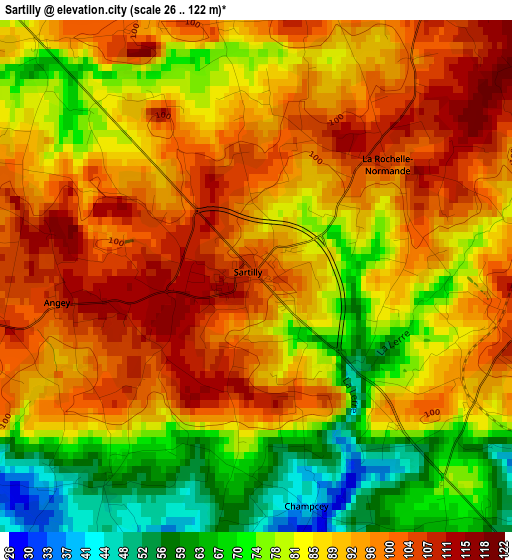
Below is the Elevation map of Sartilly, which displays elevation range with different colors. Scale of the first map is from 26 to 122 m (85 to 400 ft) with average elevation of 87.4 meters (=287 ft) [note 1]
These maps also provides idea of topography and contour of this city, they are displayed at different zoom levels. More info about maps, scale and edge coordinates you can find below images.
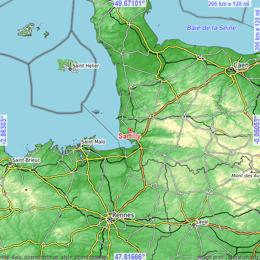
| \ | Map #1 | Topo.Map |
| Scale [m] | 26..122 m | × |
| Scale [ft] | 85..400 ft | × |
| Average | 87.4 m = 287 ft | × |
| Width | 6.44 km = 4 mi | 206.2 km = 128.1 mi |
| Height | 6.44 km = 4 mi | 206.2 km = 128.1 mi |
| ↑Max Latitude | 48.781355° | 49.67101° |
| Latitude at center | 48.75239° | 48.75239° |
| ↓Min Latitude | 48.723408° | 47.81666° |
| ← Min Longitude | -1.500725° | -2.86303° |
| Longitude center | -1.45678° | -1.45678° |
| →Max Longitude | -1.412835° | -0.05053° |
Nearby cities:
Cities around Sartilly sort by population:
• Granville elevation 12 m
14 km,  312°
312°
• Avranches 82 m
10.5 km,  135°
135°
• Saint-Pair-sur-Mer 22 m
10.7 km, 310°
• Donville-les-Bains 34 m
13.9 km,  318°
318°
• Saint-Martin-des-Champs 69 m
13 km, 136°
• Le Val-Saint-Père 13 m
11.7 km,  149°
149°
• Jullouville 12 m
8.3 km,  288°
288°
• La Haye-Pesnel 98 m
6.5 km,  42°
42°
• Saint-Planchers 47 m
9.3 km,  327°
327°
• Saint-Jean-des-Champs 96 m
8.4 km,  355°
355°
• Marcey-les-Grèves 19 m
7.8 km, 142°
• Saint-Senier-sous-Avranches 98 m
11.9 km,  129°
129°
Multilingual:
 En español:
Sartilly elevación 107 m.
 En France:
Sartilly élévation 107 m.
 Auf Deutsch:
Sartilly höhe über dem Meeresspiegel ist 107 m.

Sources and notes:
- [note 1] Map square and city borders are not equal. Map elevation data is calculated only from area inside that square.
- [src 1] Elevation data from geonames database provided with same terms of usage.
- [src 2] The elevation map of Sartilly is generated using elevation data from NASA's 3 arcsec (90m) resolution SRTM data.
- [src 3] Base (background) map © OpenStreetMap contributors tiles are generated by Geofabrik and OpenTopoMap.
Copyright & License:
This Sartilly Elevation Map is licensed under CC BY-SA. You may reuse any part from this page, if you give a proper credit by linking to this URL:
 More info on terms of use page.