Sciez elevation
Sciez (Auvergne-Rhône-Alpes, Haute-Savoie), France elevation is 438 meters and Sciez elevation in feet is 1437 ft above sea level [src 1]. Sciez is a populated place (feature code) with elevation that is 264 meters (866 ft) bigger than average city elevation in France.
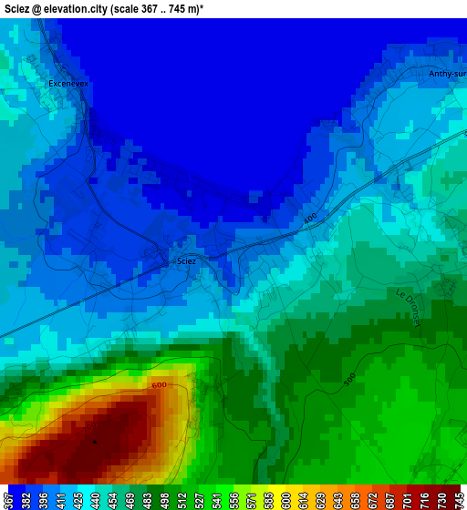
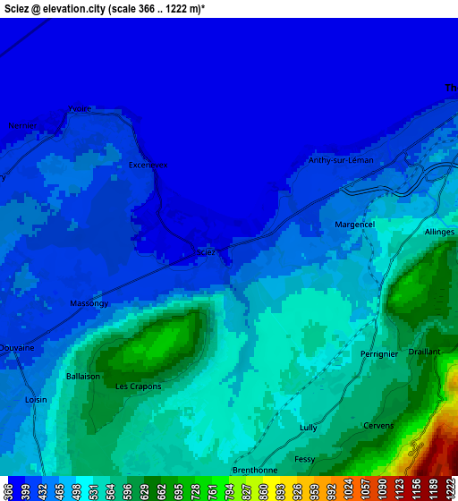
Below is the Elevation map of Sciez, which displays elevation range with different colors. Scale of the first map is from 367 to 745 m (1204 to 2444 ft) with average elevation of 449.6 meters (=1475 ft) [note 1]
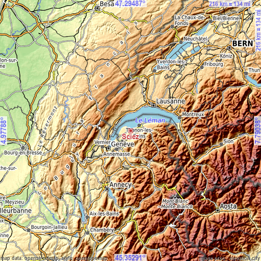
These maps also provides idea of topography and contour of this city, they are displayed at different zoom levels. More info about maps, scale and edge coordinates you can find below images.
| \ | Map #1 | Map #2 | Topo.Map |
| Scale [m] | 367..745 m | 366..1222 m | × |
| Scale [ft] | 1204..2444 ft | 1201..4009 ft | × |
| Average | 449.6 m = 1475 ft | 473.3 m = 1553 ft | × |
| Width | 6.75 km = 4.2 mi | 13.5 km = 8.4 mi | 215.9 km = 134.2 mi |
| Height | 6.75 km = 4.2 mi | 13.5 km = 8.4 mi | 215.9 km = 134.2 mi |
| ↑Max Latitude | 46.362845° | 46.393162° | 47.29487° |
| Latitude at center | 46.33251° | 46.33251° | 46.33251° |
| ↓Min Latitude | 46.302159° | 46.27179° | 45.35291° |
| ← Min Longitude | 6.340185° | 6.296239° | 4.97788° |
| Longitude center | 6.38413° | 6.38413° | 6.38413° |
| →Max Longitude | 6.428075° | 6.472021° | 7.79038° |
Nearby cities:
Cities around Sciez sort by population:
• Thonon-les-Bains elevation 437 m
8.5 km,  60°
60°
• Bons-en-Chablais 591 m
7.6 km,  187°
187°
• Douvaine 431 m
6.9 km,  244°
244°
• Allinges 532 m
6.1 km,  86°
86°
• Anthy-sur-Léman 406 m
4.2 km,  52°
52°
• Margencel 440 m
2.5 km,  66°
66°
• Messery 415 m
7.4 km,  285°
285°
• Perrignier 570 m
5.2 km,  125°
125°
• Chens-sur-Léman 426 m
8.7 km,  264°
264°
• Massongy 425 m
4.3 km,  248°
248°
• Loisin 464 m
7.2 km,  231°
231°
• Ballaison 627 m
5.8 km, 228°
Multilingual:
 En español:
Sciez elevación 438 m.
 En France:
Sciez élévation 438 m.


Sources and notes:
- [note 1] Map square and city borders are not equal. Map elevation data is calculated only from area inside that square.
- [src 1] Elevation data from geonames database provided with same terms of usage.
- [src 2] The elevation map of Sciez is generated using elevation data from NASA's 3 arcsec (90m) resolution SRTM data.
- [src 3] Base (background) map © OpenStreetMap contributors tiles are generated by Geofabrik and OpenTopoMap.
Copyright & License:
This Sciez Elevation Map is licensed under CC BY-SA. You may reuse any part from this page, if you give a proper credit by linking to this URL:
 More info on terms of use page.