Serres elevation
Serres (Provence-Alpes-Côte d'Azur, Hautes-Alpes), France elevation is 720 meters and Serres elevation in feet is 2362 ft above sea level [src 1]. Serres is a populated place (feature code) with elevation that is 546 meters (1791 ft) bigger than average city elevation in France.
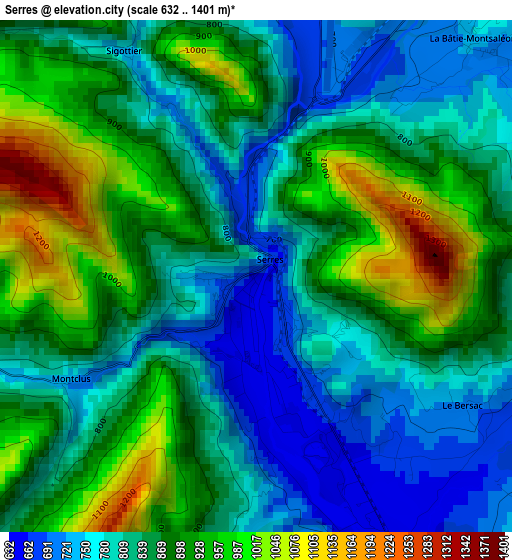
Below is the Elevation map of Serres, which displays elevation range with different colors. Scale of the first map is from 632 to 1401 m (2073 to 4596 ft) with average elevation of 856.5 meters (=2810 ft) [note 1]
These maps also provides idea of topography and contour of this city, they are displayed at different zoom levels. More info about maps, scale and edge coordinates you can find below images.
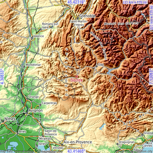
| \ | Map #1 | Topo.Map |
| Scale [m] | 632..1401 m | × |
| Scale [ft] | 2073..4596 ft | × |
| Average | 856.5 m = 2810 ft | × |
| Width | 6.98 km = 4.3 mi | 223.3 km = 138.8 mi |
| Height | 6.98 km = 4.3 mi | 223.3 km = 138.8 mi |
| ↑Max Latitude | 44.458905° | 45.42316° |
| Latitude at center | 44.42753° | 44.42753° |
| ↓Min Latitude | 44.396139° | 43.41465° |
| ← Min Longitude | 5.670635° | 4.30833° |
| Longitude center | 5.71458° | 5.71458° |
| →Max Longitude | 5.758525° | 7.12083° |
Nearby cities:
Cities around Serres sort by population:
• Gap elevation 743 m
32.3 km,  63°
63°
• Sisteron 461 m
32.2 km,  145°
145°
• Laragne-Montéglin 577 m
14.8 km, 146°
• Veynes 846 m
14.6 km,  36°
36°
• Buis-les-Baronnies 380 m
39 km,  244°
244°
• Tallard 603 m
27.1 km,  81°
81°
• La Bâtie-Neuve 910 m
41.2 km,  67°
67°
• Volonne 454 m
42.6 km, 145°
• Saint-Bonnet-en-Champsaur 1064 m
40.8 km,  45°
45°
• Mens 868 m
43.2 km,  3°
3°
• Peipin 500 m
37.6 km, 149°
• La Roche-des-Arnauds 935 m
24.2 km, 51°
Multilingual:
 En español:
Serres elevación 720 m.
 En France:
Serres élévation 720 m.


Sources and notes:
- [note 1] Map square and city borders are not equal. Map elevation data is calculated only from area inside that square.
- [src 1] Elevation data from geonames database provided with same terms of usage.
- [src 2] The elevation map of Serres is generated using elevation data from NASA's 3 arcsec (90m) resolution SRTM data.
- [src 3] Base (background) map © OpenStreetMap contributors tiles are generated by Geofabrik and OpenTopoMap.
Copyright & License:
This Serres Elevation Map is licensed under CC BY-SA. You may reuse any part from this page, if you give a proper credit by linking to this URL:
 More info on terms of use page.