Sevrey elevation
Sevrey (Bourgogne-Franche-Comté, Département de Saône-et-Loire), France elevation is 192 meters and Sevrey elevation in feet is 630 ft above sea level [src 1]. Sevrey is a populated place (feature code) with elevation that is 18 meters (59 ft) bigger than average city elevation in France.
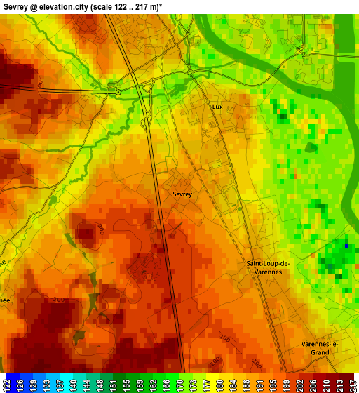
Below is the Elevation map of Sevrey, which displays elevation range with different colors. Scale of the first map is from 122 to 217 m (400 to 712 ft) with average elevation of 187.2 meters (=614 ft) [note 1]
These maps also provides idea of topography and contour of this city, they are displayed at different zoom levels. More info about maps, scale and edge coordinates you can find below images.
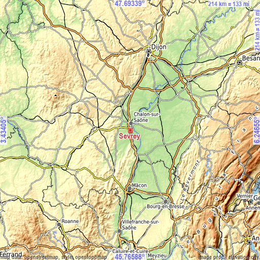
| \ | Map #1 | Topo.Map |
| Scale [m] | 122..217 m | × |
| Scale [ft] | 400..712 ft | × |
| Average | 187.2 m = 614 ft | × |
| Width | 6.7 km = 4.2 mi | 214.3 km = 133.2 mi |
| Height | 6.7 km = 4.2 mi | 214.3 km = 133.2 mi |
| ↑Max Latitude | 46.768359° | 47.69339° |
| Latitude at center | 46.73825° | 46.73825° |
| ↓Min Latitude | 46.708124° | 45.76588° |
| ← Min Longitude | 4.796355° | 3.43405° |
| Longitude center | 4.8403° | 4.8403° |
| →Max Longitude | 4.884245° | 6.24655° |
Nearby cities:
Cities around Sevrey sort by population:
• Chalon-sur-Saône elevation 175 m
4.9 km,  12°
12°
• Châtenoy-le-Royal 191 m
7 km,  341°
341°
• Saint-Rémy 185 m
2.8 km,  358°
358°
• Saint-Marcel 179 m
5.6 km,  44°
44°
• Givry 223 m
8.9 km,  303°
303°
• Ouroux-sur-Saône 192 m
8.8 km,  102°
102°
• Champforgeuil 185 m
8.9 km, 356°
• Buxy 234 m
10.7 km,  255°
255°
• Crissey 180 m
9.3 km,  19°
19°
• Varennes-le-Grand 190 m
3.1 km,  135°
135°
• Épervans 182 m
4.8 km,  70°
70°
• Dracy-le-Fort 206 m
8.9 km,  317°
317°
Multilingual:
 En español:
Sevrey elevación 192 m.
 En France:
Sevrey élévation 192 m.


Sources and notes:
- [note 1] Map square and city borders are not equal. Map elevation data is calculated only from area inside that square.
- [src 1] Elevation data from geonames database provided with same terms of usage.
- [src 2] The elevation map of Sevrey is generated using elevation data from NASA's 3 arcsec (90m) resolution SRTM data.
- [src 3] Base (background) map © OpenStreetMap contributors tiles are generated by Geofabrik and OpenTopoMap.
Copyright & License:
This Sevrey Elevation Map is licensed under CC BY-SA. You may reuse any part from this page, if you give a proper credit by linking to this URL:
 More info on terms of use page.