Sevrier elevation
Sevrier (Auvergne-Rhône-Alpes, Haute-Savoie), France elevation is 459 meters and Sevrier elevation in feet is 1506 ft above sea level [src 1]. Sevrier is a populated place (feature code) with elevation that is 285 meters (935 ft) bigger than average city elevation in France.
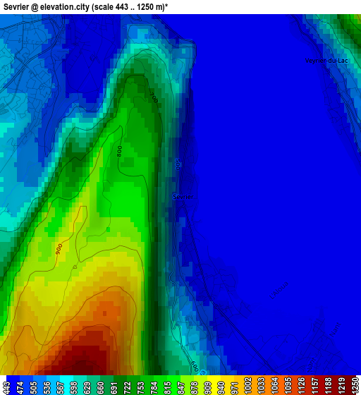
Below is the Elevation map of Sevrier, which displays elevation range with different colors. Scale of the first map is from 443 to 1250 m (1453 to 4101 ft) with average elevation of 597.2 meters (=1959 ft) [note 1]
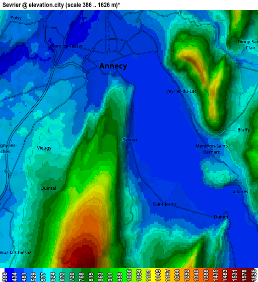
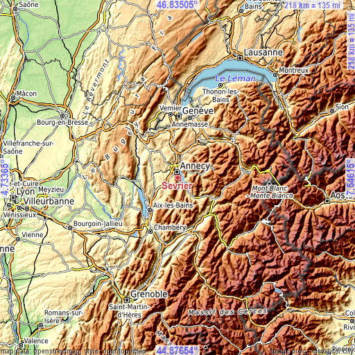
These maps also provides idea of topography and contour of this city, they are displayed at different zoom levels. More info about maps, scale and edge coordinates you can find below images.
| \ | Map #1 | Map #2 | Topo.Map |
| Scale [m] | 443..1250 m | 386..1626 m | × |
| Scale [ft] | 1453..4101 ft | 1266..5335 ft | × |
| Average | 597.2 m = 1959 ft | 640.7 m = 2102 ft | × |
| Width | 6.81 km = 4.2 mi | 13.61 km = 8.5 mi | 217.8 km = 135.3 mi |
| Height | 6.81 km = 4.2 mi | 13.61 km = 8.5 mi | 217.8 km = 135.3 mi |
| ↑Max Latitude | 45.895013° | 45.92559° | 46.83505° |
| Latitude at center | 45.86442° | 45.86442° | 45.86442° |
| ↓Min Latitude | 45.83381° | 45.803183° | 44.87654° |
| ← Min Longitude | 6.095955° | 6.052009° | 4.73365° |
| Longitude center | 6.1399° | 6.1399° | 6.1399° |
| →Max Longitude | 6.183845° | 6.227791° | 7.54615° |
Nearby cities:
Cities around Sevrier sort by population:
• Annecy elevation 451 m
5.1 km,  347°
347°
• Annecy-le-Vieux 498 m
6.2 km,  2°
2°
• Cran-Gevrier 510 m
5 km,  322°
322°
• Seynod 542 m
4.6 km,  300°
300°
• Meythet 451 m
7 km,  329°
329°
• Saint-Jorioz 478 m
4 km,  159°
159°
• Veyrier-du-Lac 628 m
3.5 km,  55°
55°
• Metz 468 m
8 km,  343°
343°
• Menthon-Saint-Bernard 487 m
4.3 km,  96°
96°
• Talloires 469 m
6.3 km,  114°
114°
• Viuz-la-Chiésaz 700 m
8.1 km,  224°
224°
• Dingy-Saint-Clair 658 m
8.1 km,  54°
54°
Multilingual:
 En español:
Sevrier elevación 459 m.
 En France:
Sevrier élévation 459 m.


Sources and notes:
- [note 1] Map square and city borders are not equal. Map elevation data is calculated only from area inside that square.
- [src 1] Elevation data from geonames database provided with same terms of usage.
- [src 2] The elevation map of Sevrier is generated using elevation data from NASA's 3 arcsec (90m) resolution SRTM data.
- [src 3] Base (background) map © OpenStreetMap contributors tiles are generated by Geofabrik and OpenTopoMap.
Copyright & License:
This Sevrier Elevation Map is licensed under CC BY-SA. You may reuse any part from this page, if you give a proper credit by linking to this URL:
 More info on terms of use page.