Soisy-sur-École elevation
Soisy-sur-École (Île-de-France, Département de l'Essonne), France elevation is 75 meters and Soisy-sur-École elevation in feet is 246 ft above sea level [src 1]. Soisy-sur-École is a populated place (feature code) with elevation that is 99 meters (325 ft) smaller than average city elevation in France.
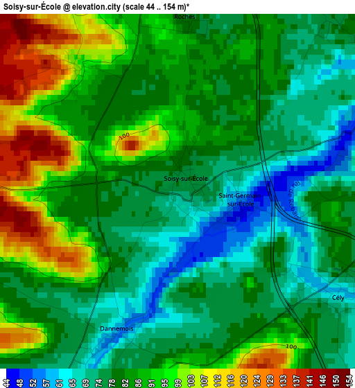
Below is the Elevation map of Soisy-sur-École, which displays elevation range with different colors. Scale of the first map is from 44 to 154 m (144 to 505 ft) with average elevation of 84 meters (=276 ft) [note 1]
These maps also provides idea of topography and contour of this city, they are displayed at different zoom levels. More info about maps, scale and edge coordinates you can find below images.
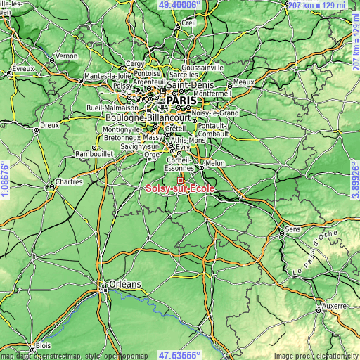
| \ | Map #1 | Topo.Map |
| Scale [m] | 44..154 m | × |
| Scale [ft] | 144..505 ft | × |
| Average | 84 m = 276 ft | × |
| Width | 6.48 km = 4 mi | 207.3 km = 128.8 mi |
| Height | 6.48 km = 4 mi | 207.3 km = 128.8 mi |
| ↑Max Latitude | 48.505494° | 49.40006° |
| Latitude at center | 48.47637° | 48.47637° |
| ↓Min Latitude | 48.447229° | 47.53555° |
| ← Min Longitude | 2.449065° | 1.08676° |
| Longitude center | 2.49301° | 2.49301° |
| →Max Longitude | 2.536955° | 3.89926° |
Nearby cities:
Cities around Soisy-sur-École sort by population:
• Ponthierry elevation 45 m
7.4 km,  30°
30°
• Milly-la-Forêt 67 m
8.2 km,  191°
191°
• Boissise-le-Roi 68 m
7.8 km,  46°
46°
• Champcueil 80 m
5.6 km,  322°
322°
• Pringy 74 m
7 km, 48°
• Chailly-en-Bière 82 m
8.5 km,  97°
97°
• Perthes 82 m
4.6 km,  87°
87°
• Chevannes 83 m
7.2 km,  329°
329°
• Moigny-sur-École 62 m
5.5 km,  207°
207°
• Saint-Sauveur-sur-École 68 m
4.6 km,  59°
59°
• Cély 59 m
3.5 km,  122°
122°
• Arbonne-la-Forêt 72 m
8.8 km,  141°
141°
Multilingual:
 En español:
Soisy-sur-École elevación 75 m.
 En France:
Soisy-sur-École élévation 75 m.
 Auf Deutsch:
Soisy-sur-École höhe über dem Meeresspiegel ist 75 m.

Sources and notes:
- [note 1] Map square and city borders are not equal. Map elevation data is calculated only from area inside that square.
- [src 1] Elevation data from geonames database provided with same terms of usage.
- [src 2] The elevation map of Soisy-sur-École is generated using elevation data from NASA's 3 arcsec (90m) resolution SRTM data.
- [src 3] Base (background) map © OpenStreetMap contributors tiles are generated by Geofabrik and OpenTopoMap.
Copyright & License:
This Soisy-sur-École Elevation Map is licensed under CC BY-SA. You may reuse any part from this page, if you give a proper credit by linking to this URL:
 More info on terms of use page.