Talmas elevation
Talmas (Hauts-de-France, Somme), France elevation is 136 meters and Talmas elevation in feet is 446 ft above sea level [src 1]. Talmas is a populated place (feature code) with elevation that is 38 meters (125 ft) smaller than average city elevation in France.
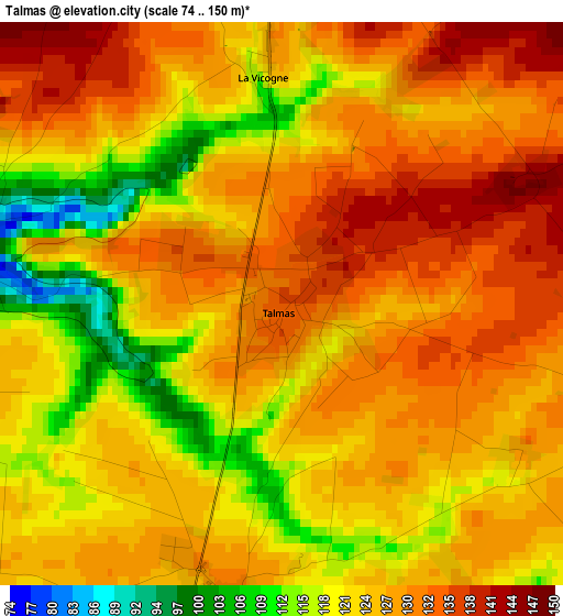
Below is the Elevation map of Talmas, which displays elevation range with different colors. Scale of the first map is from 74 to 150 m (243 to 492 ft) with average elevation of 125.4 meters (=411 ft) [note 1]
These maps also provides idea of topography and contour of this city, they are displayed at different zoom levels. More info about maps, scale and edge coordinates you can find below images.
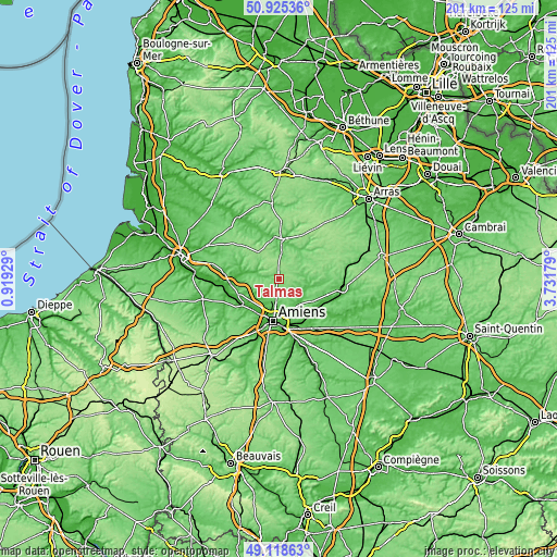
| \ | Map #1 | Topo.Map |
| Scale [m] | 74..150 m | × |
| Scale [ft] | 243..492 ft | × |
| Average | 125.4 m = 411 ft | × |
| Width | 6.28 km = 3.9 mi | 200.9 km = 124.8 mi |
| Height | 6.28 km = 3.9 mi | 200.9 km = 124.8 mi |
| ↑Max Latitude | 50.058711° | 50.92536° |
| Latitude at center | 50.03049° | 50.03049° |
| ↓Min Latitude | 50.002252° | 49.11863° |
| ← Min Longitude | 2.281595° | 0.91929° |
| Longitude center | 2.32554° | 2.32554° |
| →Max Longitude | 2.369485° | 3.73179° |
Nearby cities:
Cities around Talmas sort by population:
• Doullens elevation 60 m
14.1 km,  4°
4°
• Rivery 44 m
14.1 km,  180°
180°
• Beauval 106 m
8.6 km, 3°
• Vignacourt 126 m
9.4 km,  257°
257°
• Flesselles 127 m
5.6 km,  235°
235°
• Saint-Léger-lès-Domart 31 m
13.4 km,  280°
280°
• Saint-Sauveur 26 m
13.1 km,  218°
218°
• Villers-Bocage 129 m
3.7 km,  189°
189°
• Poulainville 68 m
9.3 km, 185°
• Beauquesne 141 m
7.8 km,  38°
38°
• Naours 70 m
3.5 km, 281°
• Berteaucourt-les-Dames 42 m
12.1 km, 278°
Multilingual:
 En español:
Talmas elevación 136 m.
 En France:
Talmas élévation 136 m.


Sources and notes:
- [note 1] Map square and city borders are not equal. Map elevation data is calculated only from area inside that square.
- [src 1] Elevation data from geonames database provided with same terms of usage.
- [src 2] The elevation map of Talmas is generated using elevation data from NASA's 3 arcsec (90m) resolution SRTM data.
- [src 3] Base (background) map © OpenStreetMap contributors tiles are generated by Geofabrik and OpenTopoMap.
Copyright & License:
This Talmas Elevation Map is licensed under CC BY-SA. You may reuse any part from this page, if you give a proper credit by linking to this URL:
 More info on terms of use page.