Tavaux elevation
Tavaux (Bourgogne-Franche-Comté, Jura), France elevation is 192 meters and Tavaux elevation in feet is 630 ft above sea level [src 1]. Tavaux is a populated place (feature code) with elevation that is 18 meters (59 ft) bigger than average city elevation in France.
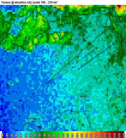
Below is the Elevation map of Tavaux, which displays elevation range with different colors. Scale of the first map is from 184 to 219 m (604 to 719 ft) with average elevation of 191.7 meters (=629 ft) [note 1]
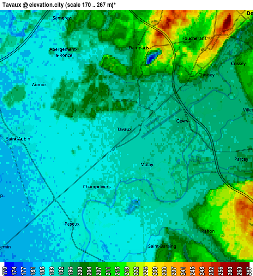
These maps also provides idea of topography and contour of this city, they are displayed at different zoom levels. More info about maps, scale and edge coordinates you can find below images.
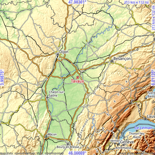
| \ | Map #1 | Map #2 | Topo.Map |
| Scale [m] | 184..219 m | 170..267 m | × |
| Scale [ft] | 604..719 ft | 558..876 ft | × |
| Average | 191.7 m = 629 ft | 196 m = 643 ft | × |
| Width | 6.66 km = 4.1 mi | 13.32 km = 8.3 mi | 213.1 km = 132.4 mi |
| Height | 6.66 km = 4.1 mi | 13.32 km = 8.3 mi | 213.1 km = 132.4 mi |
| ↑Max Latitude | 47.063703° | 47.09363° | 47.98361° |
| Latitude at center | 47.03376° | 47.03376° | 47.03376° |
| ↓Min Latitude | 47.0038° | 46.973823° | 46.06669° |
| ← Min Longitude | 5.361055° | 5.317109° | 3.99875° |
| Longitude center | 5.405° | 5.405° | 5.405° |
| →Max Longitude | 5.448945° | 5.492891° | 6.81125° |
Nearby cities:
Cities around Tavaux sort by population:
• Dole elevation 222 m
9.1 km,  44°
44°
• Damparis 212 m
4.7 km,  8°
8°
• Foucherans 209 m
6.5 km, 35°
• Chaussin 189 m
7.5 km,  178°
178°
• Saint-Aubin 189 m
5.9 km,  269°
269°
• Champvans 221 m
8.3 km,  17°
17°
• Losne 180 m
13 km,  303°
303°
• Saint-Jean-de-Losne 183 m
13 km,  305°
305°
• Mont-sous-Vaudrey 217 m
16.2 km,  112°
112°
• Choisey 215 m
5.3 km,  50°
50°
• Saint-Usage 184 m
13.9 km, 307°
• Petit-Noir 179 m
12.4 km,  205°
205°
Multilingual:
 En español:
Tavaux elevación 192 m.
 En France:
Tavaux élévation 192 m.


Sources and notes:
- [note 1] Map square and city borders are not equal. Map elevation data is calculated only from area inside that square.
- [src 1] Elevation data from geonames database provided with same terms of usage.
- [src 2] The elevation map of Tavaux is generated using elevation data from NASA's 3 arcsec (90m) resolution SRTM data.
- [src 3] Base (background) map © OpenStreetMap contributors tiles are generated by Geofabrik and OpenTopoMap.
Copyright & License:
This Tavaux Elevation Map is licensed under CC BY-SA. You may reuse any part from this page, if you give a proper credit by linking to this URL:
 More info on terms of use page.