Thiais elevation
Thiais (Île-de-France, Val-de-Marne), France elevation is 51 meters and Thiais elevation in feet is 167 ft above sea level [src 1]. Thiais is a populated place (feature code) with elevation that is 123 meters (404 ft) smaller than average city elevation in France.
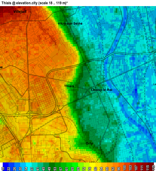
Below is the Elevation map of Thiais, which displays elevation range with different colors. Scale of the first map is from 18 to 119 m (59 to 390 ft) with average elevation of 62.4 meters (=205 ft) [note 1]
These maps also provides idea of topography and contour of this city, they are displayed at different zoom levels. More info about maps, scale and edge coordinates you can find below images.
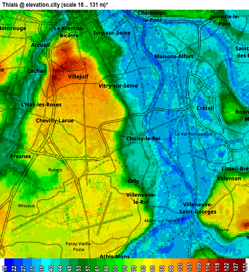
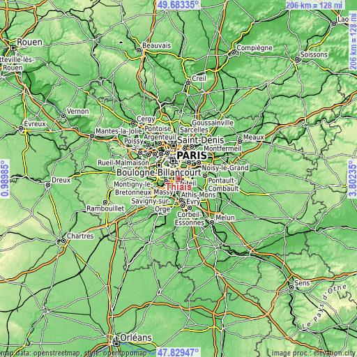
| \ | Map #1 | Map #2 | Topo.Map |
| Scale [m] | 18..119 m | 18..131 m | × |
| Scale [ft] | 59..390 ft | 59..430 ft | × |
| Average | 62.4 m = 205 ft | 61 m = 200 ft | × |
| Width | 6.44 km = 4 mi | 12.88 km = 8 mi | 206.1 km = 128.1 mi |
| Height | 6.44 km = 4 mi | 12.88 km = 8 mi | 206.1 km = 128.1 mi |
| ↑Max Latitude | 48.793918° | 48.82286° | 49.68335° |
| Latitude at center | 48.76496° | 48.76496° | 48.76496° |
| ↓Min Latitude | 48.735985° | 48.706994° | 47.82947° |
| ← Min Longitude | 2.352155° | 2.308209° | 0.98985° |
| Longitude center | 2.3961° | 2.3961° | 2.3961° |
| →Max Longitude | 2.440045° | 2.483991° | 3.80235° |
Nearby cities:
Cities around Thiais sort by population:
• Vitry-sur-Seine elevation 32 m
2.5 km,  12°
12°
• Villejuif 110 m
4.2 km,  320°
320°
• Alfortville 36 m
4.9 km,  21°
21°
• Choisy-le-Roi 34 m
1.7 km,  76°
76°
• Villeneuve-Saint-Georges 35 m
5.3 km,  133°
133°
• L'Haÿ-les-Roses 62 m
5 km,  293°
293°
• Orly 81 m
1.9 km,  187°
187°
• Chevilly-Larue 89 m
3.4 km,  269°
269°
• Villeneuve-le-Roi 86 m
3.1 km,  173°
173°
• Valenton 52 m
5.5 km,  113°
113°
• Rungis 86 m
3.8 km,  236°
236°
• Ablon-sur-Seine 34 m
4.8 km,  151°
151°
Multilingual:
 En español:
Thiais elevación 51 m.
 En France:
Thiais élévation 51 m.


Sources and notes:
- [note 1] Map square and city borders are not equal. Map elevation data is calculated only from area inside that square.
- [src 1] Elevation data from geonames database provided with same terms of usage.
- [src 2] The elevation map of Thiais is generated using elevation data from NASA's 3 arcsec (90m) resolution SRTM data.
- [src 3] Base (background) map © OpenStreetMap contributors tiles are generated by Geofabrik and OpenTopoMap.
Copyright & License:
This Thiais Elevation Map is licensed under CC BY-SA. You may reuse any part from this page, if you give a proper credit by linking to this URL:
 More info on terms of use page.