Toucy elevation
Toucy (Bourgogne-Franche-Comté, Département de l'Yonne), France elevation is 205 meters and Toucy elevation in feet is 673 ft above sea level [src 1]. Toucy is a populated place (feature code) with elevation that is 31 meters (102 ft) bigger than average city elevation in France.
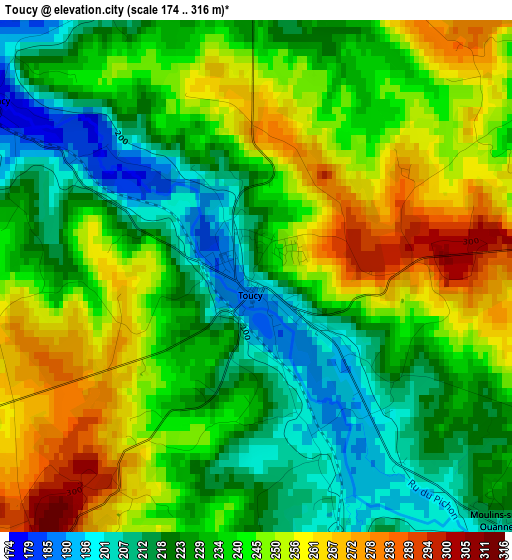
Below is the Elevation map of Toucy, which displays elevation range with different colors. Scale of the first map is from 174 to 316 m (571 to 1037 ft) with average elevation of 237.1 meters (=778 ft) [note 1]
These maps also provides idea of topography and contour of this city, they are displayed at different zoom levels. More info about maps, scale and edge coordinates you can find below images.
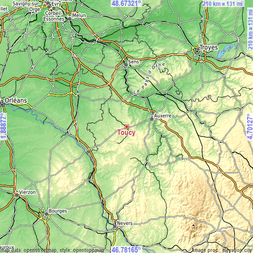
| \ | Map #1 | Topo.Map |
| Scale [m] | 174..316 m | × |
| Scale [ft] | 571..1037 ft | × |
| Average | 237.1 m = 778 ft | × |
| Width | 6.57 km = 4.1 mi | 210.3 km = 130.7 mi |
| Height | 6.57 km = 4.1 mi | 210.3 km = 130.7 mi |
| ↑Max Latitude | 47.765567° | 48.67321° |
| Latitude at center | 47.73602° | 47.73602° |
| ↓Min Latitude | 47.706456° | 46.78165° |
| ← Min Longitude | 3.251075° | 1.88877° |
| Longitude center | 3.29502° | 3.29502° |
| →Max Longitude | 3.338965° | 4.70127° |
Nearby cities:
Cities around Toucy sort by population:
• Auxerre elevation 100 m
21.8 km,  71°
71°
• Saint-Georges-sur-Baulche 159 m
19.1 km, 67°
• Appoigny 94 m
23.1 km,  48°
48°
• Charny 136 m
22.4 km,  318°
318°
• Saint-Fargeau 189 m
19.8 km,  237°
237°
• Champs-sur-Yonne 102 m
22.8 km,  90°
90°
• Charbuy 157 m
16 km, 52°
• Aillant-sur-Tholon 117 m
15.9 km,  15°
15°
• Pourrain 261 m
9 km,  75°
75°
• Diges 219 m
7.7 km,  96°
96°
• Champignelles 181 m
17.2 km,  286°
286°
• Fleury-la-Vallée 137 m
18.5 km,  38°
38°
Multilingual:
 En español:
Toucy elevación 205 m.
 En France:
Toucy élévation 205 m.


Sources and notes:
- [note 1] Map square and city borders are not equal. Map elevation data is calculated only from area inside that square.
- [src 1] Elevation data from geonames database provided with same terms of usage.
- [src 2] The elevation map of Toucy is generated using elevation data from NASA's 3 arcsec (90m) resolution SRTM data.
- [src 3] Base (background) map © OpenStreetMap contributors tiles are generated by Geofabrik and OpenTopoMap.
Copyright & License:
This Toucy Elevation Map is licensed under CC BY-SA. You may reuse any part from this page, if you give a proper credit by linking to this URL:
 More info on terms of use page.