Urrugne elevation
Urrugne (Nouvelle-Aquitaine, Département des Pyrénées-Atlantiques), France elevation is 26 meters and Urrugne elevation in feet is 85 ft above sea level [src 1]. Urrugne is a populated place (feature code) with elevation that is 148 meters (486 ft) smaller than average city elevation in France.
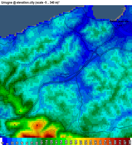
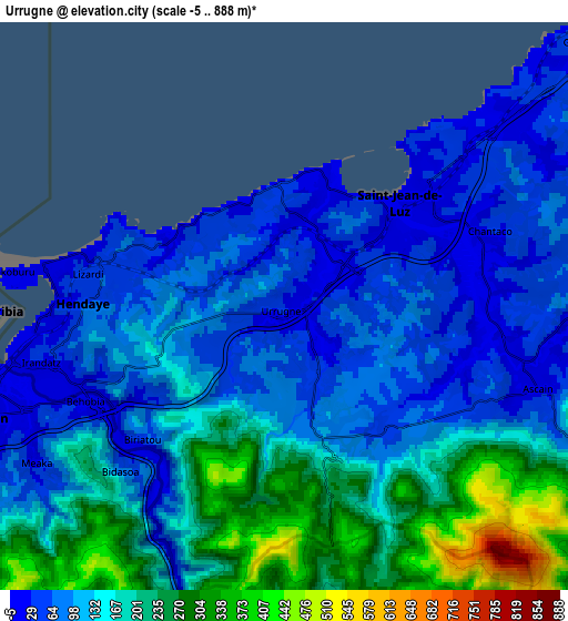
Below is the Elevation map of Urrugne, which displays elevation range with different colors. Scale of the first map is from -5 to 340 m (-16 to 1115 ft) with average elevation of 62.8 meters (=206 ft) [note 1]
These maps also provides idea of topography and contour of this city, they are displayed at different zoom levels. More info about maps, scale and edge coordinates you can find below images.
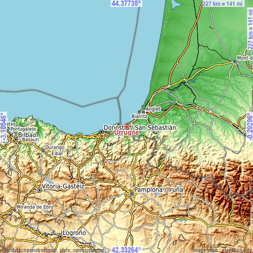
| \ | Map #1 | Map #2 | Topo.Map |
| Scale [m] | -5..340 m | -5..888 m | × |
| Scale [ft] | -16..1115 ft | -16..2913 ft | × |
| Average | 62.8 m = 206 ft | 139.7 m = 458 ft | × |
| Width | 7.1 km = 4.4 mi | 14.21 km = 8.8 mi | 227.4 km = 141.3 mi |
| Height | 7.1 km = 4.4 mi | 14.21 km = 8.8 mi | 227.3 km = 141.2 mi |
| ↑Max Latitude | 43.39555° | 43.427474° | 44.37735° |
| Latitude at center | 43.36361° | 43.36361° | 43.36361° |
| ↓Min Latitude | 43.331653° | 43.299679° | 42.33264° |
| ← Min Longitude | -1.743155° | -1.787101° | -3.10546° |
| Longitude center | -1.69921° | -1.69921° | -1.69921° |
| →Max Longitude | -1.655265° | -1.611319° | -0.29296° |
Nearby cities:
Cities around Urrugne sort by population:
• Saint-Jean-de-Luz elevation 8 m
4.1 km,  46°
46°
• Hendaye 8 m
6.1 km,  278°
278°
• Ciboure 70 m
2.8 km,  41°
41°
• Bidart 29 m
12 km, 46°
• Saint-Pée-sur-Nivelle 21 m
12.1 km,  94°
94°
• Ascain 25 m
6.7 km,  107°
107°
• Arcangues 50 m
16.1 km,  62°
62°
• Bassussarry 70 m
17.2 km, 59°
• Sare 81 m
11.2 km,  120°
120°
• Arbonne 36 m
14.2 km, 57°
• Ahetze 24 m
11.2 km,  66°
66°
• Guéthary 46 m
9.7 km, 47°
Multilingual:
 En español:
Urruña elevación 26 m.
 En France:
Urrugne élévation 26 m.


Sources and notes:
- [note 1] Map square and city borders are not equal. Map elevation data is calculated only from area inside that square.
- [src 1] Elevation data from geonames database provided with same terms of usage.
- [src 2] The elevation map of Urrugne is generated using elevation data from NASA's 3 arcsec (90m) resolution SRTM data.
- [src 3] Base (background) map © OpenStreetMap contributors tiles are generated by Geofabrik and OpenTopoMap.
Copyright & License:
This Urrugne Elevation Map is licensed under CC BY-SA. You may reuse any part from this page, if you give a proper credit by linking to this URL:
 More info on terms of use page.