Vals-les-Bains elevation
Vals-les-Bains (Auvergne-Rhône-Alpes, Département de l'Ardèche), France elevation is 299 meters and Vals-les-Bains elevation in feet is 981 ft above sea level [src 1]. Vals-les-Bains is a populated place (feature code) with elevation that is 125 meters (410 ft) bigger than average city elevation in France.
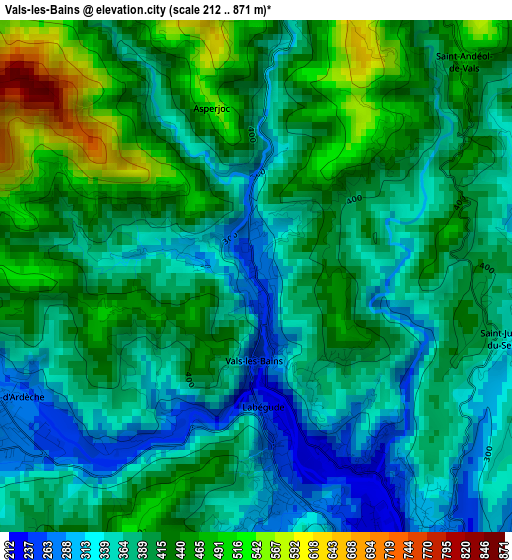
Below is the Elevation map of Vals-les-Bains, which displays elevation range with different colors. Scale of the first map is from 212 to 871 m (696 to 2858 ft) with average elevation of 395.1 meters (=1296 ft) [note 1]
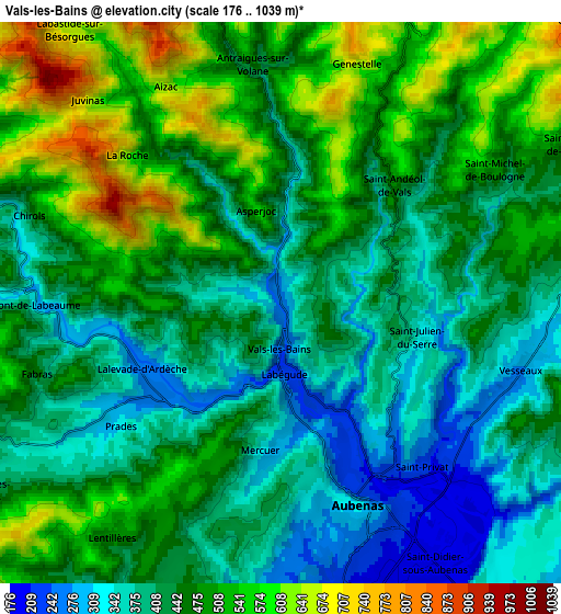
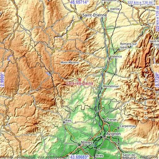
These maps also provides idea of topography and contour of this city, they are displayed at different zoom levels. More info about maps, scale and edge coordinates you can find below images.
| \ | Map #1 | Map #2 | Topo.Map |
| Scale [m] | 212..871 m | 176..1039 m | × |
| Scale [ft] | 696..2858 ft | 577..3409 ft | × |
| Average | 395.1 m = 1296 ft | 450.8 m = 1479 ft | × |
| Width | 6.95 km = 4.3 mi | 13.9 km = 8.6 mi | 222.4 km = 138.2 mi |
| Height | 6.95 km = 4.3 mi | 13.9 km = 8.6 mi | 222.4 km = 138.2 mi |
| ↑Max Latitude | 44.696856° | 44.728086° | 45.65714° |
| Latitude at center | 44.66561° | 44.66561° | 44.66561° |
| ↓Min Latitude | 44.634347° | 44.603067° | 43.65683° |
| ← Min Longitude | 4.322205° | 4.278259° | 2.9599° |
| Longitude center | 4.36615° | 4.36615° | 4.36615° |
| →Max Longitude | 4.410095° | 4.454041° | 5.7724° |
Nearby cities:
Cities around Vals-les-Bains sort by population:
• Aubenas elevation 320 m
5.4 km,  159°
159°
• Saint-Étienne-de-Fontbellon 195 m
7.4 km,  167°
167°
• Largentière 268 m
14.8 km,  202°
202°
• Lavilledieu 221 m
12.2 km,  145°
145°
• Saint-Privat 214 m
5.6 km,  136°
136°
• Labégude 260 m
2.3 km, 173°
• Lachapelle-sous-Aubenas 211 m
11.3 km,  180°
180°
• Vesseaux 294 m
6.1 km,  104°
104°
• Saint-Sernin 183 m
10.7 km, 168°
• Lalevade-d’Ardèche 255 m
3.9 km,  239°
239°
• Jaujac 439 m
9.2 km,  249°
249°
• Thueyts 518 m
11.5 km,  275°
275°
Multilingual:
 En español:
Vals-les-Bains elevación 299 m.
 En France:
Vals-les-Bains élévation 299 m.
 Auf Deutsch:
Vals-les-Bains höhe über dem Meeresspiegel ist 299 m.

Sources and notes:
- [note 1] Map square and city borders are not equal. Map elevation data is calculated only from area inside that square.
- [src 1] Elevation data from geonames database provided with same terms of usage.
- [src 2] The elevation map of Vals-les-Bains is generated using elevation data from NASA's 3 arcsec (90m) resolution SRTM data.
- [src 3] Base (background) map © OpenStreetMap contributors tiles are generated by Geofabrik and OpenTopoMap.
Copyright & License:
This Vals-les-Bains Elevation Map is licensed under CC BY-SA. You may reuse any part from this page, if you give a proper credit by linking to this URL:
 More info on terms of use page.