Vals-près-le-Puy elevation
Vals-près-le-Puy (Auvergne-Rhône-Alpes, Haute-Loire), France elevation is 646 meters and Vals-près-le-Puy elevation in feet is 2119 ft above sea level [src 1]. Vals-près-le-Puy is a populated place (feature code) with elevation that is 472 meters (1549 ft) bigger than average city elevation in France.
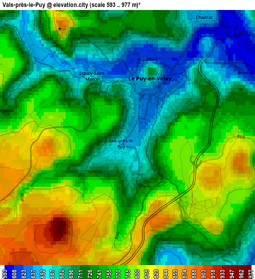
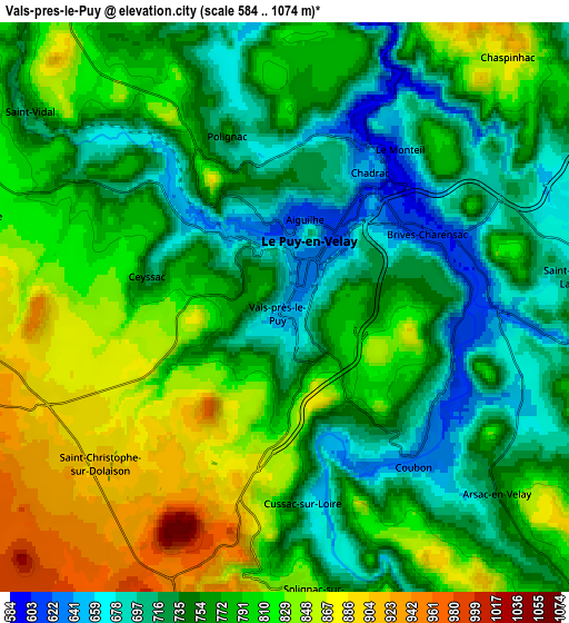
Below is the Elevation map of Vals-près-le-Puy, which displays elevation range with different colors. Scale of the first map is from 593 to 977 m (1946 to 3205 ft) with average elevation of 745.8 meters (=2447 ft) [note 1]
These maps also provides idea of topography and contour of this city, they are displayed at different zoom levels. More info about maps, scale and edge coordinates you can find below images.
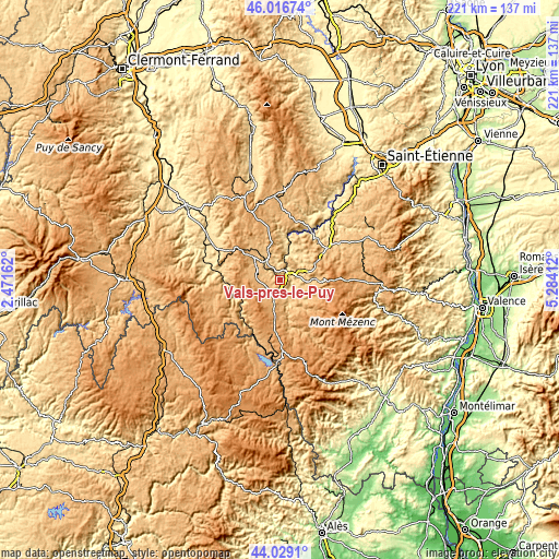
| \ | Map #1 | Map #2 | Topo.Map |
| Scale [m] | 593..977 m | 584..1074 m | × |
| Scale [ft] | 1946..3205 ft | 1916..3524 ft | × |
| Average | 745.8 m = 2447 ft | 775.5 m = 2544 ft | × |
| Width | 6.91 km = 4.3 mi | 13.81 km = 8.6 mi | 221 km = 137.3 mi |
| Height | 6.91 km = 4.3 mi | 13.81 km = 8.6 mi | 221 km = 137.3 mi |
| ↑Max Latitude | 45.062598° | 45.09363° | 46.01674° |
| Latitude at center | 45.03155° | 45.03155° | 45.03155° |
| ↓Min Latitude | 45.000485° | 44.969402° | 44.0291° |
| ← Min Longitude | 3.833925° | 3.789979° | 2.47162° |
| Longitude center | 3.87787° | 3.87787° | 3.87787° |
| →Max Longitude | 3.921815° | 3.965761° | 5.28412° |
Nearby cities:
Cities around Vals-près-le-Puy sort by population:
• Le Puy-en-Velay elevation 640 m
1.5 km,  23°
23°
• Brives-Charensac 610 m
4.4 km,  65°
65°
• Espaly-Saint-Marcel 639 m
2.1 km,  332°
332°
• Saint-Germain-Laprade 673 m
7.3 km,  83°
83°
• Chadrac 643 m
3.9 km,  30°
30°
• Coubon 629 m
4.9 km,  140°
140°
• Polignac 751 m
4.6 km,  342°
342°
• Lantriac 737 m
10.5 km,  109°
109°
• Cussac-sur-Loire 677 m
4.9 km,  174°
174°
• Blavozy 703 m
8.5 km, 70°
• Bains 979 m
8.4 km,  253°
253°
• Solignac-sur-Loire 853 m
7.1 km, 174°
Multilingual:
 En español:
Vals-près-le-Puy elevación 646 m.
 En France:
Vals-près-le-Puy élévation 646 m.
 Auf Deutsch:
Vals-près-le-Puy höhe über dem Meeresspiegel ist 646 m.

Sources and notes:
- [note 1] Map square and city borders are not equal. Map elevation data is calculated only from area inside that square.
- [src 1] Elevation data from geonames database provided with same terms of usage.
- [src 2] The elevation map of Vals-près-le-Puy is generated using elevation data from NASA's 3 arcsec (90m) resolution SRTM data.
- [src 3] Base (background) map © OpenStreetMap contributors tiles are generated by Geofabrik and OpenTopoMap.
Copyright & License:
This Vals-près-le-Puy Elevation Map is licensed under CC BY-SA. You may reuse any part from this page, if you give a proper credit by linking to this URL:
 More info on terms of use page.