Verberie elevation
Verberie (Hauts-de-France, Département de l'Oise), France elevation is 39 meters and Verberie elevation in feet is 128 ft above sea level [src 1]. Verberie is a populated place (feature code) with elevation that is 135 meters (443 ft) smaller than average city elevation in France.
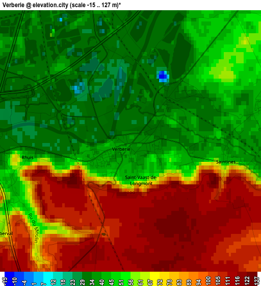
Below is the Elevation map of Verberie, which displays elevation range with different colors. Scale of the first map is from -15 to 127 m (-49 to 417 ft) with average elevation of 62.6 meters (=205 ft) [note 1]
These maps also provides idea of topography and contour of this city, they are displayed at different zoom levels. More info about maps, scale and edge coordinates you can find below images.
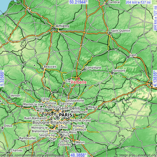
| \ | Map #1 | Topo.Map |
| Scale [m] | -15..127 m | × |
| Scale [ft] | -49..417 ft | × |
| Average | 62.6 m = 205 ft | × |
| Width | 6.37 km = 4 mi | 203.9 km = 126.7 mi |
| Height | 6.37 km = 4 mi | 203.9 km = 126.7 mi |
| ↑Max Latitude | 49.339792° | 50.21944° |
| Latitude at center | 49.31115° | 49.31115° |
| ↓Min Latitude | 49.282491° | 48.3858° |
| ← Min Longitude | 2.688155° | 1.32585° |
| Longitude center | 2.7321° | 2.7321° |
| →Max Longitude | 2.776045° | 4.13835° |
Nearby cities:
Cities around Verberie sort by population:
• Pont-Sainte-Maxence elevation 37 m
9.3 km,  263°
263°
• Lacroix-Saint-Ouen 39 m
6.5 km,  38°
38°
• Béthisy-Saint-Pierre 64 m
4.7 km,  98°
98°
• Pontpoint 50 m
6.1 km, 258°
• Jaux 32 m
9.5 km,  20°
20°
• Le Meux 52 m
6.3 km,  7°
7°
• Chevrières 39 m
5.3 km,  317°
317°
• Saint-Sauveur 56 m
3.8 km,  77°
77°
• Grandfresnoy 89 m
8.9 km, 319°
• Longueil-Sainte-Marie 41 m
5.2 km,  349°
349°
• Les Ageux 31 m
9.6 km,  273°
273°
• Béthisy-Saint-Martin 48 m
6.4 km,  106°
106°
Multilingual:
 En español:
Verberie elevación 39 m.
 En France:
Verberie élévation 39 m.


Sources and notes:
- [note 1] Map square and city borders are not equal. Map elevation data is calculated only from area inside that square.
- [src 1] Elevation data from geonames database provided with same terms of usage.
- [src 2] The elevation map of Verberie is generated using elevation data from NASA's 3 arcsec (90m) resolution SRTM data.
- [src 3] Base (background) map © OpenStreetMap contributors tiles are generated by Geofabrik and OpenTopoMap.
Copyright & License:
This Verberie Elevation Map is licensed under CC BY-SA. You may reuse any part from this page, if you give a proper credit by linking to this URL:
 More info on terms of use page.