Vernouillet elevation
Vernouillet (Centre, Département d'Eure-et-Loir), France elevation is 129 meters and Vernouillet elevation in feet is 423 ft above sea level [src 1]. Vernouillet is a populated place (feature code) with elevation that is 45 meters (148 ft) smaller than average city elevation in France.
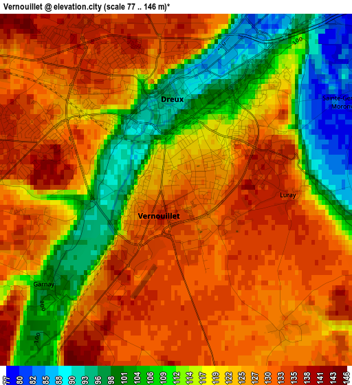
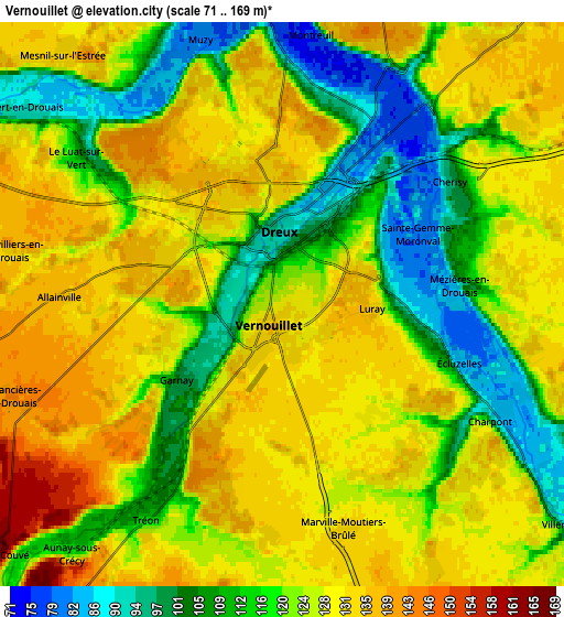
Below is the Elevation map of Vernouillet, which displays elevation range with different colors. Scale of the first map is from 77 to 146 m (253 to 479 ft) with average elevation of 121 meters (=397 ft) [note 1]
These maps also provides idea of topography and contour of this city, they are displayed at different zoom levels. More info about maps, scale and edge coordinates you can find below images.
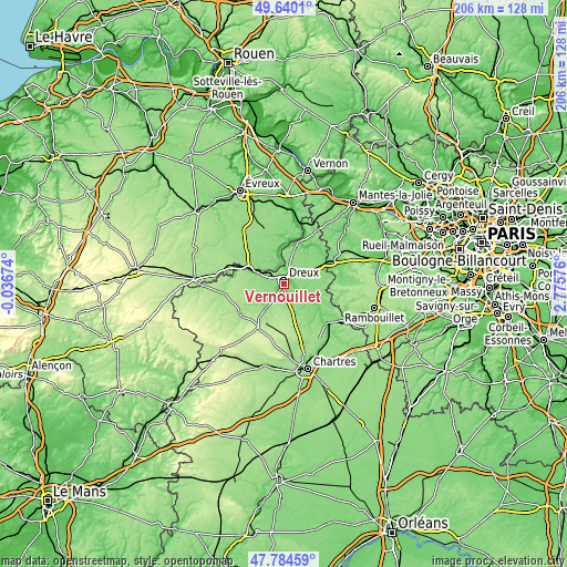
| \ | Map #1 | Map #2 | Topo.Map |
| Scale [m] | 77..146 m | 71..169 m | × |
| Scale [ft] | 253..479 ft | 233..554 ft | × |
| Average | 121 m = 397 ft | 122.8 m = 403 ft | × |
| Width | 6.45 km = 4 mi | 12.89 km = 8 mi | 206.3 km = 128.2 mi |
| Height | 6.45 km = 4 mi | 12.89 km = 8 mi | 206.3 km = 128.2 mi |
| ↑Max Latitude | 48.749884° | 48.77885° | 49.6401° |
| Latitude at center | 48.7209° | 48.7209° | 48.7209° |
| ↓Min Latitude | 48.6919° | 48.662883° | 47.78459° |
| ← Min Longitude | 1.325565° | 1.281619° | -0.03674° |
| Longitude center | 1.36951° | 1.36951° | 1.36951° |
| →Max Longitude | 1.413455° | 1.457401° | 2.77576° |
Nearby cities:
Cities around Vernouillet sort by population:
• Dreux elevation 91 m
1.8 km,  350°
350°
• Saint-Rémy-sur-Avre 103 m
10.2 km,  296°
296°
• Cherisy 129 m
5.7 km,  55°
55°
• Abondant 135 m
8.9 km,  35°
35°
• Villemeux-sur-Eure 92 m
8.8 km,  127°
127°
• Chaudon 92 m
11.4 km,  124°
124°
• Luray 133 m
2.2 km,  91°
91°
• Tréon 111 m
5.8 km,  212°
212°
• Saint-Germain-sur-Avre 97 m
8.9 km, 303°
• Mézières-en-Drouais 86 m
4 km,  84°
84°
• Vert-en-Drouais 91 m
7 km,  308°
308°
• Garnay 102 m
3 km,  233°
233°
Multilingual:
 En español:
Vernouillet elevación 129 m.
 En France:
Vernouillet élévation 129 m.
 Auf Deutsch:
Vernouillet höhe über dem Meeresspiegel ist 129 m.

Sources and notes:
- [note 1] Map square and city borders are not equal. Map elevation data is calculated only from area inside that square.
- [src 1] Elevation data from geonames database provided with same terms of usage.
- [src 2] The elevation map of Vernouillet is generated using elevation data from NASA's 3 arcsec (90m) resolution SRTM data.
- [src 3] Base (background) map © OpenStreetMap contributors tiles are generated by Geofabrik and OpenTopoMap.
Copyright & License:
This Vernouillet Elevation Map is licensed under CC BY-SA. You may reuse any part from this page, if you give a proper credit by linking to this URL:
 More info on terms of use page.