Vilallonga dels Monts elevation
Vilallonga dels Monts (Occitanie, Département des Pyrénées-Orientales), France elevation is 120 meters and Vilallonga dels Monts elevation in feet is 394 ft above sea level [src 1]. Vilallonga dels Monts is a populated place (feature code) with elevation that is 54 meters (177 ft) smaller than average city elevation in France.
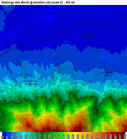
Below is the Elevation map of Vilallonga dels Monts, which displays elevation range with different colors. Scale of the first map is from 32 to 952 m (105 to 3123 ft) with average elevation of 212.3 meters (=697 ft) [note 1]
These maps also provides idea of topography and contour of this city, they are displayed at different zoom levels. More info about maps, scale and edge coordinates you can find below images.
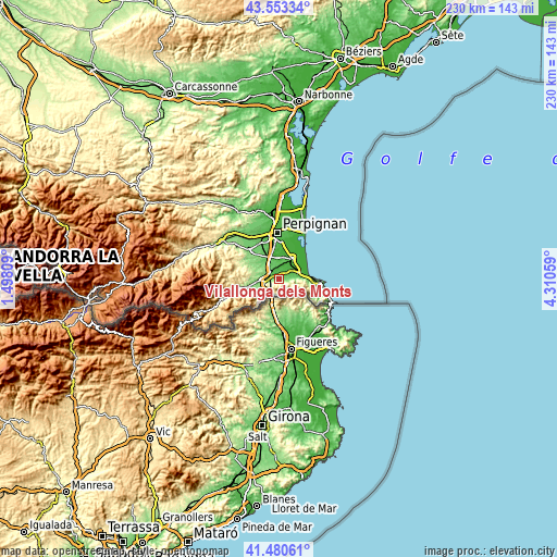
| \ | Map #1 | Topo.Map |
| Scale [m] | 32..952 m | × |
| Scale [ft] | 105..3123 ft | × |
| Average | 212.3 m = 697 ft | × |
| Width | 7.2 km = 4.5 mi | 230.5 km = 143.2 mi |
| Height | 7.2 km = 4.5 mi | 230.5 km = 143.2 mi |
| ↑Max Latitude | 42.557948° | 43.55334° |
| Latitude at center | 42.52557° | 42.52557° |
| ↓Min Latitude | 42.493175° | 41.48061° |
| ← Min Longitude | 2.860395° | 1.49809° |
| Longitude center | 2.90434° | 2.90434° |
| →Max Longitude | 2.948285° | 4.31059° |
Nearby cities:
Cities around Vilallonga dels Monts sort by population:
• el Voló elevation 87 m
5.8 km,  268°
268°
• Bages 25 m
9 km,  354°
354°
• Sorède 76 m
4.4 km,  82°
82°
• Sant Andreu de Sureda 37 m
6.2 km,  61°
61°
• Saint-Génis-des-Fontaines 57 m
2.4 km,  34°
34°
• Maureillas-las-Illas 131 m
8.9 km,  243°
243°
• Palau-del-Vidre 25 m
6.9 km,  41°
41°
• la Roca d'Albera 110 m
2.5 km,  101°
101°
• Ortaffa 32 m
6.3 km,  16°
16°
• Banyuls-dels-Aspres 119 m
5.4 km,  325°
325°
• Montesquiu d'Albera 174 m
2 km, 244°
• Villemolaque 92 m
8.8 km,  322°
322°
Multilingual:
 En español:
Vilallonga dels Monts elevación 120 m.
 En France:
Villelongue-dels-Monts élévation 120 m.
 Auf Deutsch:
Vilallonga dels Monts höhe über dem Meeresspiegel ist 120 m.
 На русском:
Vilallonga dels Monts высота над уровнем моря 120 м
Sources and notes:
- [note 1] Map square and city borders are not equal. Map elevation data is calculated only from area inside that square.
- [src 1] Elevation data from geonames database provided with same terms of usage.
- [src 2] The elevation map of Vilallonga dels Monts is generated using elevation data from NASA's 3 arcsec (90m) resolution SRTM data.
- [src 3] Base (background) map © OpenStreetMap contributors tiles are generated by Geofabrik and OpenTopoMap.
Copyright & License:
This Vilallonga dels Monts Elevation Map is licensed under CC BY-SA. You may reuse any part from this page, if you give a proper credit by linking to this URL:
 More info on terms of use page.