Villiers-sur-Loir elevation
Villiers-sur-Loir (Centre, Département du Loir-et-Cher), France elevation is 91 meters and Villiers-sur-Loir elevation in feet is 299 ft above sea level [src 1]. Villiers-sur-Loir is a populated place (feature code) with elevation that is 83 meters (272 ft) smaller than average city elevation in France.
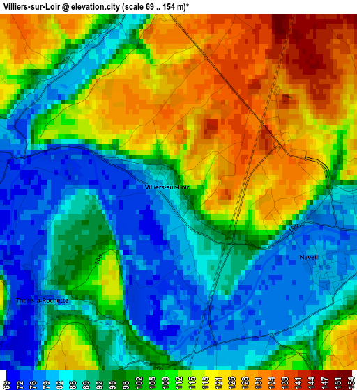
Below is the Elevation map of Villiers-sur-Loir, which displays elevation range with different colors. Scale of the first map is from 69 to 154 m (226 to 505 ft) with average elevation of 102.9 meters (=338 ft) [note 1]
These maps also provides idea of topography and contour of this city, they are displayed at different zoom levels. More info about maps, scale and edge coordinates you can find below images.
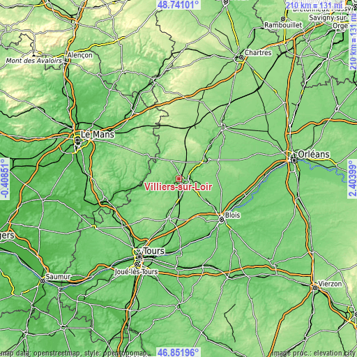
| \ | Map #1 | Topo.Map |
| Scale [m] | 69..154 m | × |
| Scale [ft] | 226..505 ft | × |
| Average | 102.9 m = 338 ft | × |
| Width | 6.56 km = 4.1 mi | 210 km = 130.5 mi |
| Height | 6.56 km = 4.1 mi | 210 km = 130.5 mi |
| ↑Max Latitude | 47.834578° | 48.74101° |
| Latitude at center | 47.80507° | 47.80507° |
| ↓Min Latitude | 47.775546° | 46.85196° |
| ← Min Longitude | 0.953795° | -0.40851° |
| Longitude center | 0.99774° | 0.99774° |
| →Max Longitude | 1.041685° | 2.40399° |
Nearby cities:
Cities around Villiers-sur-Loir sort by population:
• Vendôme elevation 80 m
5.2 km,  104°
104°
• Montoire-sur-le-Loir 68 m
11.5 km,  239°
239°
• Saint-Ouen 122 m
6.3 km,  80°
80°
• Bessé-sur-Braye 77 m
18.8 km,  279°
279°
• Savigny-sur-Braye 89 m
16.3 km,  300°
300°
• Naveil 79 m
2.8 km,  111°
111°
• Lunay 100 m
6.2 km,  273°
273°
• La Ville-aux-Clercs 145 m
14.2 km,  27°
27°
• Saint-Amand-Longpré 120 m
13.6 km,  174°
174°
• Morée 97 m
20.8 km,  58°
58°
• Azé 100 m
5.2 km,  0°
0°
• Sargé-sur-Braye 98 m
17 km,  320°
320°
Multilingual:
 En español:
Villiers-sur-Loir elevación 91 m.
 En France:
Villiers-sur-Loir élévation 91 m.
 Auf Deutsch:
Villiers-sur-Loir höhe über dem Meeresspiegel ist 91 m.

Sources and notes:
- [note 1] Map square and city borders are not equal. Map elevation data is calculated only from area inside that square.
- [src 1] Elevation data from geonames database provided with same terms of usage.
- [src 2] The elevation map of Villiers-sur-Loir is generated using elevation data from NASA's 3 arcsec (90m) resolution SRTM data.
- [src 3] Base (background) map © OpenStreetMap contributors tiles are generated by Geofabrik and OpenTopoMap.
Copyright & License:
This Villiers-sur-Loir Elevation Map is licensed under CC BY-SA. You may reuse any part from this page, if you give a proper credit by linking to this URL:
 More info on terms of use page.