Vinay elevation
Vinay (Auvergne-Rhône-Alpes, Département de l'Isère), France elevation is 254 meters and Vinay elevation in feet is 833 ft above sea level [src 1]. Vinay is a populated place (feature code) with elevation that is 80 meters (262 ft) bigger than average city elevation in France.
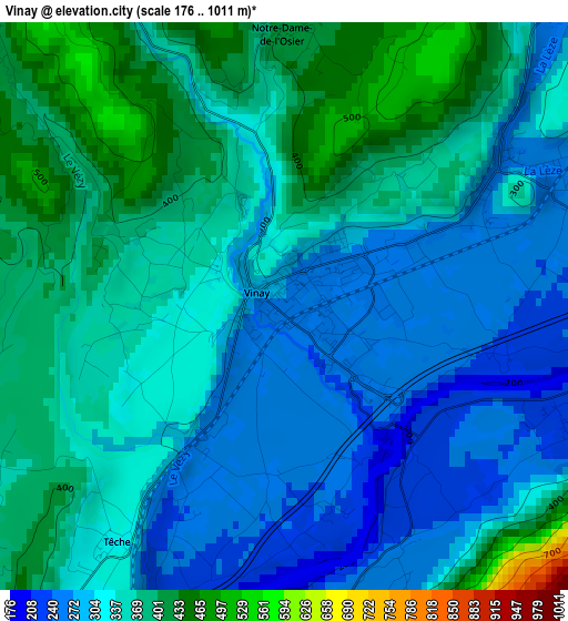
Below is the Elevation map of Vinay, which displays elevation range with different colors. Scale of the first map is from 176 to 1011 m (577 to 3317 ft) with average elevation of 335.4 meters (=1100 ft) [note 1]
These maps also provides idea of topography and contour of this city, they are displayed at different zoom levels. More info about maps, scale and edge coordinates you can find below images.
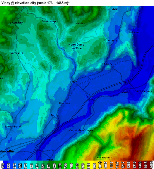
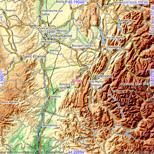
| \ | Map #1 | Map #2 | Topo.Map |
| Scale [m] | 176..1011 m | 173..1465 m | × |
| Scale [ft] | 577..3317 ft | 568..4806 ft | × |
| Average | 335.4 m = 1100 ft | 442.7 m = 1452 ft | × |
| Width | 6.88 km = 4.3 mi | 13.77 km = 8.6 mi | 220.3 km = 136.9 mi |
| Height | 6.88 km = 4.3 mi | 13.77 km = 8.6 mi | 220.3 km = 136.9 mi |
| ↑Max Latitude | 45.239272° | 45.270208° | 46.19044° |
| Latitude at center | 45.20832° | 45.20832° | 45.20832° |
| ↓Min Latitude | 45.177351° | 45.146365° | 44.20894° |
| ← Min Longitude | 5.362515° | 5.318569° | 4.00021° |
| Longitude center | 5.40646° | 5.40646° | 5.40646° |
| →Max Longitude | 5.450405° | 5.494351° | 6.81271° |
Nearby cities:
Cities around Vinay sort by population:
• Tullins elevation 198 m
12.4 km,  32°
32°
• Saint-Marcellin 268 m
9.6 km,  226°
226°
• Chatte 295 m
12.2 km, 233°
• Izeaux 425 m
14.1 km,  5°
5°
• Saint-Sauveur 255 m
7.4 km,  214°
214°
• Autrans 1063 m
11.3 km,  108°
108°
• Saint-Vérand 294 m
7 km,  236°
236°
• Saint-Romans 240 m
12.5 km, 211°
• Sillans 406 m
15 km,  354°
354°
• Roybon 542 m
13.8 km,  293°
293°
• Saint-Quentin-sur-Isère 279 m
13.3 km,  54°
54°
• Méaudre 988 m
12.9 km,  132°
132°
Multilingual:
 En español:
Vinay elevación 254 m.
 En France:
Vinay élévation 254 m.


Sources and notes:
- [note 1] Map square and city borders are not equal. Map elevation data is calculated only from area inside that square.
- [src 1] Elevation data from geonames database provided with same terms of usage.
- [src 2] The elevation map of Vinay is generated using elevation data from NASA's 3 arcsec (90m) resolution SRTM data.
- [src 3] Base (background) map © OpenStreetMap contributors tiles are generated by Geofabrik and OpenTopoMap.
Copyright & License:
This Vinay Elevation Map is licensed under CC BY-SA. You may reuse any part from this page, if you give a proper credit by linking to this URL:
 More info on terms of use page.