Vouvray elevation
Vouvray (Centre, Département d'Indre-et-Loire), France elevation is 54 meters and Vouvray elevation in feet is 177 ft above sea level [src 1]. Vouvray is a populated place (feature code) with elevation that is 120 meters (394 ft) smaller than average city elevation in France.
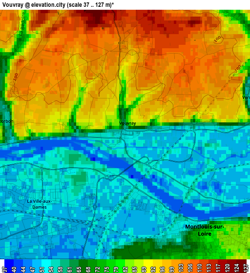
Below is the Elevation map of Vouvray, which displays elevation range with different colors. Scale of the first map is from 37 to 127 m (121 to 417 ft) with average elevation of 75 meters (=246 ft) [note 1]
These maps also provides idea of topography and contour of this city, they are displayed at different zoom levels. More info about maps, scale and edge coordinates you can find below images.
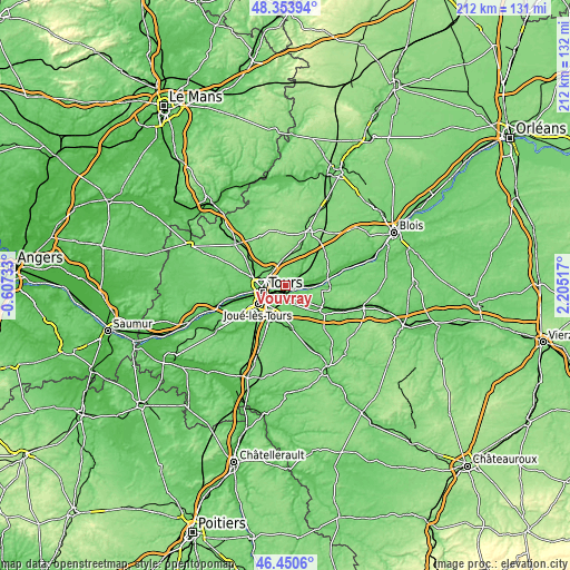
| \ | Map #1 | Topo.Map |
| Scale [m] | 37..127 m | × |
| Scale [ft] | 121..417 ft | × |
| Average | 75 m = 246 ft | × |
| Width | 6.61 km = 4.1 mi | 211.6 km = 131.5 mi |
| Height | 6.61 km = 4.1 mi | 211.6 km = 131.5 mi |
| ↑Max Latitude | 47.440601° | 48.35394° |
| Latitude at center | 47.41087° | 47.41087° |
| ↓Min Latitude | 47.381122° | 46.4506° |
| ← Min Longitude | 0.754975° | -0.60733° |
| Longitude center | 0.79892° | 0.79892° |
| →Max Longitude | 0.842865° | 2.20517° |
Nearby cities:
Cities around Vouvray sort by population:
• Tours elevation 49 m
7.4 km,  255°
255°
• Saint-Avertin 87 m
6.9 km,  220°
220°
• Saint-Pierre-des-Corps 50 m
4.7 km,  234°
234°
• Montlouis-sur-Loire 80 m
3.5 km,  134°
134°
• La Ville-aux-Dames 52 m
2.9 km, 233°
• Véretz 76 m
6 km,  175°
175°
• Rochecorbon 59 m
3.3 km,  280°
280°
• Azay-sur-Cher 64 m
7.7 km,  152°
152°
• Vernou-sur-Brenne 53 m
3.8 km,  75°
75°
• Parçay-Meslay 104 m
5.1 km,  312°
312°
• Larçay 82 m
5.1 km,  194°
194°
• Noizay 58 m
7.1 km, 80°
Multilingual:
 En español:
Vouvray elevación 54 m.
 En France:
Vouvray élévation 54 m.


Sources and notes:
- [note 1] Map square and city borders are not equal. Map elevation data is calculated only from area inside that square.
- [src 1] Elevation data from geonames database provided with same terms of usage.
- [src 2] The elevation map of Vouvray is generated using elevation data from NASA's 3 arcsec (90m) resolution SRTM data.
- [src 3] Base (background) map © OpenStreetMap contributors tiles are generated by Geofabrik and OpenTopoMap.
Copyright & License:
This Vouvray Elevation Map is licensed under CC BY-SA. You may reuse any part from this page, if you give a proper credit by linking to this URL:
 More info on terms of use page.