Yvetot elevation
Yvetot (Normandy, Seine-Maritime), France elevation is 148 meters and Yvetot elevation in feet is 486 ft above sea level [src 1]. Yvetot is a populated place (feature code) with elevation that is 26 meters (85 ft) smaller than average city elevation in France.
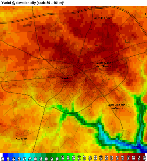
Below is the Elevation map of Yvetot, which displays elevation range with different colors. Scale of the first map is from 56 to 161 m (184 to 528 ft) with average elevation of 134.1 meters (=440 ft) [note 1]
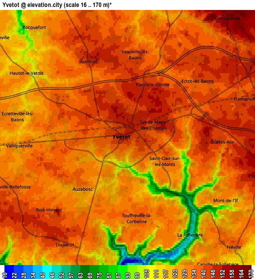
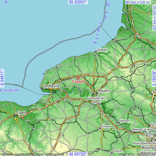
These maps also provides idea of topography and contour of this city, they are displayed at different zoom levels. More info about maps, scale and edge coordinates you can find below images.
| \ | Map #1 | Map #2 | Topo.Map |
| Scale [m] | 56..161 m | 16..170 m | × |
| Scale [ft] | 184..528 ft | 52..558 ft | × |
| Average | 134.1 m = 440 ft | 131.9 m = 433 ft | × |
| Width | 6.33 km = 3.9 mi | 12.66 km = 7.9 mi | 202.6 km = 125.9 mi |
| Height | 6.33 km = 3.9 mi | 12.66 km = 7.9 mi | 202.6 km = 125.9 mi |
| ↑Max Latitude | 49.645903° | 49.67435° | 50.52003° |
| Latitude at center | 49.61744° | 49.61744° | 49.61744° |
| ↓Min Latitude | 49.58896° | 49.560463° | 48.69782° |
| ← Min Longitude | 0.714195° | 0.670249° | -0.64811° |
| Longitude center | 0.75814° | 0.75814° | 0.75814° |
| →Max Longitude | 0.802085° | 0.846031° | 2.16439° |
Nearby cities:
Cities around Yvetot sort by population:
• Doudeville elevation 122 m
11.9 km,  9°
9°
• Caudebec-en-Caux 9 m
10.5 km,  192°
192°
• Yerville 161 m
11.4 km,  60°
60°
• Fauville-en-Caux 129 m
12.6 km,  288°
288°
• Sainte-Marie-des-Champs 149 m
1.6 km,  74°
74°
• Sainte-Marguerite-sur-Duclair 111 m
13.6 km,  153°
153°
• Limésy 149 m
12 km,  92°
92°
• Saint-Arnoult 133 m
11.9 km,  211°
211°
• Auzebosc 135 m
3.2 km,  221°
221°
• Valliquerville 131 m
5.1 km,  265°
265°
• Saint-Wandrille-Rançon 31 m
10.1 km,  177°
177°
• Bouville 118 m
11.6 km,  122°
122°
Multilingual:
 En español:
Yvetot elevación 148 m.
 En France:
Yvetot élévation 148 m.


Sources and notes:
- [note 1] Map square and city borders are not equal. Map elevation data is calculated only from area inside that square.
- [src 1] Elevation data from geonames database provided with same terms of usage.
- [src 2] The elevation map of Yvetot is generated using elevation data from NASA's 3 arcsec (90m) resolution SRTM data.
- [src 3] Base (background) map © OpenStreetMap contributors tiles are generated by Geofabrik and OpenTopoMap.
Copyright & License:
This Yvetot Elevation Map is licensed under CC BY-SA. You may reuse any part from this page, if you give a proper credit by linking to this URL:
 More info on terms of use page.