Ivalo elevation
Ivalo (Lapland, Pohjois-Lappi), Finland elevation is 121 meters and Ivalo elevation in feet is 397 ft above sea level [src 1]. Ivalo is a populated place (feature code) with elevation that is 44 meters (144 ft) bigger than average city elevation in Finland.
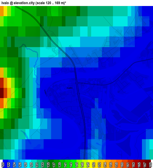
Below is the Elevation map of Ivalo, which displays elevation range with different colors. Scale of the first map is from 120 to 169 m (394 to 554 ft) with average elevation of 126.6 meters (=415 ft) [note 1]
These maps also provides idea of topography and contour of this city, they are displayed at different zoom levels. More info about maps, scale and edge coordinates you can find below images.
| \ | Map #1 | Map #2 | Topo.Map |
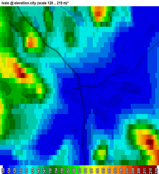
| Scale [m] | 120..169 m | 120..219 m | × |
| Scale [ft] | 394..554 ft | 394..719 ft | × |
| Average | 126.6 m = 415 ft | 138 m = 453 ft | × |
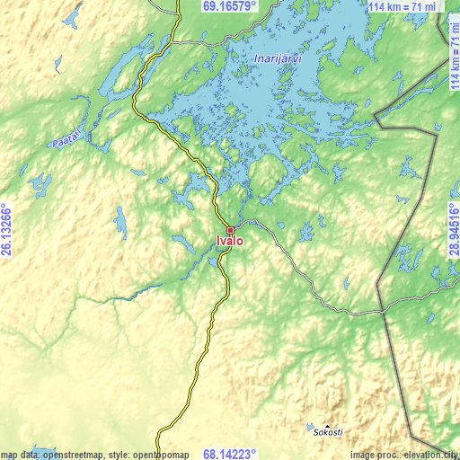
| Width | 3.56 km = 2.2 mi | 7.11 km = 4.4 mi | 113.8 km = 70.7 mi |
| Height | 3.56 km = 2.2 mi | 7.11 km = 4.4 mi | 113.8 km = 70.7 mi |
| ↑Max Latitude | 68.675846° | 68.691821° | 69.16579° |
| Latitude at center | 68.65986° | 68.65986° | 68.65986° |
| ↓Min Latitude | 68.643862° | 68.627853° | 68.14223° |
| ← Min Longitude | 27.494965° | 27.451019° | 26.13266° |
| Longitude center | 27.53891° | 27.53891° | 27.53891° |
| →Max Longitude | 27.582855° | 27.626801° | 28.94516° |
Nearby cities:
Cities around Ivalo sort by population:
• Sodankylä elevation 191 m
143.6 km,  195°
195°
• Kemijärvi 173 m
216.5 km,  181°
181°
• Inari 122 m
34.2 km,  323°
323°
• Pyhäjärvi 182 m
177.3 km, 184°
• Kittilä 179 m
155.6 km,  224°
224°
• Salla 197 m
208.6 km,  166°
166°
• Kolari 153 m
215.3 km,  226°
226°
• Muonio 232 m
176.4 km,  243°
243°
• Enontekiö 299 m
161.9 km,  259°
259°
• Utsjoki 71 m
140.3 km,  351°
351°
• Savukoski 188 m
154.2 km, 170°
• Pelkosenniemi 159 m
172.2 km, 180°
Multilingual:
 En español:
Ivalo elevación 121 m.
 En France:
Ivalo élévation 121 m.


Sources and notes:
- [note 1] Map square and city borders are not equal. Map elevation data is calculated only from area inside that square.
- [src 1] Elevation data from geonames database provided with same terms of usage.
- [src 2] The elevation map of Ivalo is generated using GMTED2010 database with 7.5 arcsec (225m) resolution.
- [src 3] Base (background) map © OpenStreetMap contributors tiles are generated by Geofabrik and OpenTopoMap.
Copyright & License:
This Ivalo Elevation Map is licensed under CC BY-SA. You may reuse any part from this page, if you give a proper credit by linking to this URL:
 More info on terms of use page.