Salla elevation
Salla (Lapland, Itä-Lappi), Finland elevation is 197 meters and Salla elevation in feet is 646 ft above sea level [src 1]. Salla is a seat of a third-order administrative division (feature code) with elevation that is 120 meters (394 ft) bigger than average city elevation in Finland.
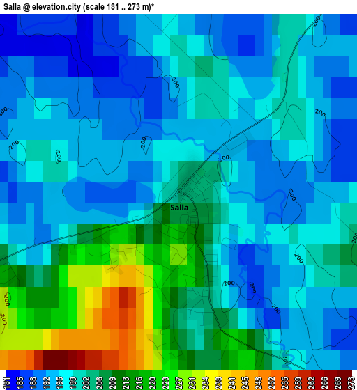
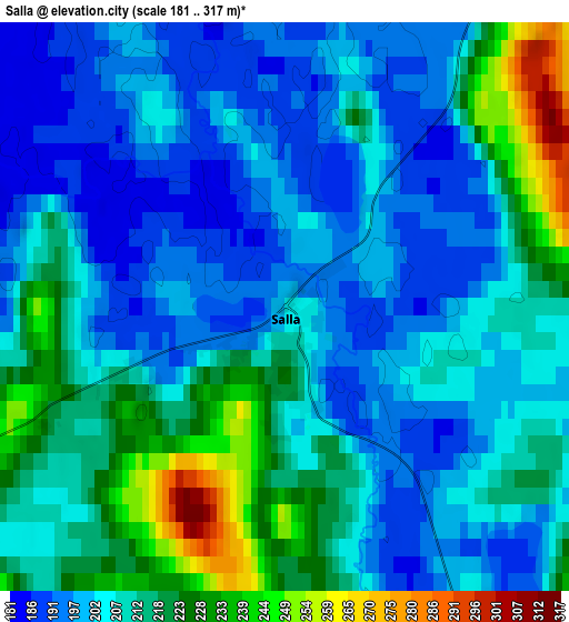
Below is the Elevation map of Salla, which displays elevation range with different colors. Scale of the first map is from 181 to 273 m (594 to 896 ft) with average elevation of 201.7 meters (=662 ft) [note 1]
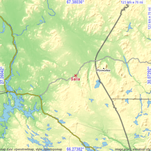
These maps also provides idea of topography and contour of this city, they are displayed at different zoom levels. More info about maps, scale and edge coordinates you can find below images.
| \ | Map #1 | Map #2 | Topo.Map |
| Scale [m] | 181..273 m | 181..317 m | × |
| Scale [ft] | 594..896 ft | 594..1040 ft | × |
| Average | 201.7 m = 662 ft | 208.5 m = 684 ft | × |
| Width | 3.84 km = 2.4 mi | 7.69 km = 4.8 mi | 123 km = 76.4 mi |
| Height | 3.84 km = 2.4 mi | 7.69 km = 4.8 mi | 123 km = 76.4 mi |
| ↑Max Latitude | 66.850612° | 66.867882° | 67.38036° |
| Latitude at center | 66.83333° | 66.83333° | 66.83333° |
| ↓Min Latitude | 66.816036° | 66.798729° | 66.27382° |
| ← Min Longitude | 28.622725° | 28.578779° | 27.26042° |
| Longitude center | 28.66667° | 28.66667° | 28.66667° |
| →Max Longitude | 28.710615° | 28.754561° | 30.07292° |
Nearby cities:
Cities around Salla sort by population:
• Rovaniemi elevation 92 m
135.1 km,  254°
254°
• Kuusamo 262 m
99.1 km,  166°
166°
• Pudasjärvi 115 m
179.4 km,  206°
206°
• Sodankylä 191 m
110.4 km,  305°
305°
• Kemijärvi 173 m
55.8 km,  256°
256°
• Pyhäjärvi 182 m
68.4 km,  292°
292°
• Kittilä 179 m
186.7 km,  299°
299°
• Ranua 152 m
139.4 km,  223°
223°
• Taivalkoski 207 m
142.1 km,  187°
187°
• Posio 255 m
83.5 km,  195°
195°
• Savukoski 188 m
55.6 km,  336°
336°
• Pelkosenniemi 159 m
59 km, 301°
Multilingual:
 En español:
Salla elevación 197 m.
 En France:
Salla élévation 197 m.


Sources and notes:
- [note 1] Map square and city borders are not equal. Map elevation data is calculated only from area inside that square.
- [src 1] Elevation data from geonames database provided with same terms of usage.
- [src 2] The elevation map of Salla is generated using GMTED2010 database with 7.5 arcsec (225m) resolution.
- [src 3] Base (background) map © OpenStreetMap contributors tiles are generated by Geofabrik and OpenTopoMap.
Copyright & License:
This Salla Elevation Map is licensed under CC BY-SA. You may reuse any part from this page, if you give a proper credit by linking to this URL:
 More info on terms of use page.