Juva elevation
Juva (South Savo, Pieksämäki), Finland elevation is 98 meters and Juva elevation in feet is 322 ft above sea level [src 1]. Juva is a seat of a third-order administrative division (feature code) with elevation that is 21 meters (69 ft) bigger than average city elevation in Finland.
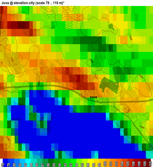
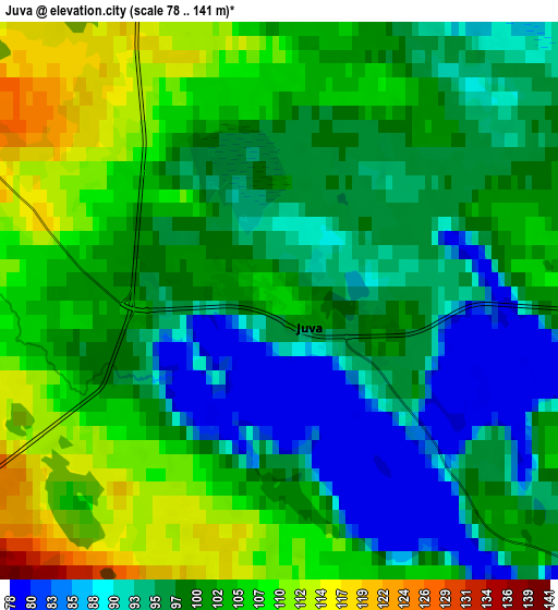
Below is the Elevation map of Juva, which displays elevation range with different colors. Scale of the first map is from 78 to 110 m (256 to 361 ft) with average elevation of 91.8 meters (=301 ft) [note 1]
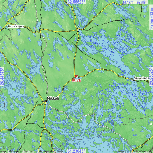
These maps also provides idea of topography and contour of this city, they are displayed at different zoom levels. More info about maps, scale and edge coordinates you can find below images.
| \ | Map #1 | Map #2 | Topo.Map |
| Scale [m] | 78..110 m | 78..141 m | × |
| Scale [ft] | 256..361 ft | 256..463 ft | × |
| Average | 91.8 m = 301 ft | 99.5 m = 326 ft | × |
| Width | 4.6 km = 2.9 mi | 9.21 km = 5.7 mi | 147.3 km = 91.5 mi |
| Height | 4.6 km = 2.9 mi | 9.21 km = 5.7 mi | 147.3 km = 91.5 mi |
| ↑Max Latitude | 61.920692° | 61.94137° | 62.55523° |
| Latitude at center | 61.9° | 61.9° | 61.9° |
| ↓Min Latitude | 61.879294° | 61.858574° | 61.23043° |
| ← Min Longitude | 27.806055° | 27.762109° | 26.44375° |
| Longitude center | 27.85° | 27.85° | 27.85° |
| →Max Longitude | 27.893945° | 27.937891° | 29.25625° |
Nearby cities:
Cities around Juva sort by population:
• Mikkeli elevation 85 m
38.4 km,  232°
232°
• Savonlinna 75 m
54.1 km,  93°
93°
• Varkaus 76 m
46.2 km,  1°
1°
• Joroinen 96 m
31 km,  358°
358°
• Ristiina 68 m
54.2 km,  215°
215°
• Rantasalmi 62 m
29.9 km,  51°
51°
• Sulkava 98 m
30.2 km,  114°
114°
• Puumala 109 m
44.8 km,  157°
157°
• Haukivuori 124 m
35.5 km,  291°
291°
• Kangaslampi 91 m
48.7 km,  25°
25°
• Jäppilä 112 m
57.5 km,  337°
337°
• Virtasalmi 115 m
32.3 km,  321°
321°
Multilingual:
 En español:
Juva elevación 98 m.
 En France:
Juva élévation 98 m.


Sources and notes:
- [note 1] Map square and city borders are not equal. Map elevation data is calculated only from area inside that square.
- [src 1] Elevation data from geonames database provided with same terms of usage.
- [src 2] The elevation map of Juva is generated using GMTED2010 database with 7.5 arcsec (225m) resolution.
- [src 3] Base (background) map © OpenStreetMap contributors tiles are generated by Geofabrik and OpenTopoMap.
Copyright & License:
This Juva Elevation Map is licensed under CC BY-SA. You may reuse any part from this page, if you give a proper credit by linking to this URL:
 More info on terms of use page.