Varkaus elevation
Varkaus (Northern Savonia), Finland elevation is 76 meters and Varkaus elevation in feet is 249 ft above sea level [src 1]. Varkaus is a seat of a third-order administrative division (feature code) with elevation that is 1 meters (3 ft) smaller than average city elevation in Finland.
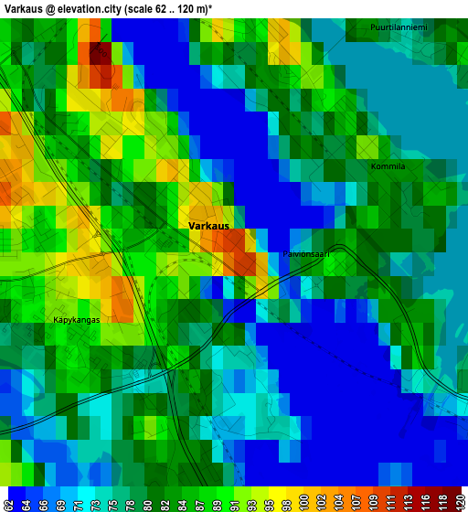
Below is the Elevation map of Varkaus, which displays elevation range with different colors. Scale of the first map is from 62 to 120 m (203 to 394 ft) with average elevation of 79.1 meters (=260 ft) [note 1]
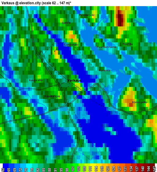
These maps also provides idea of topography and contour of this city, they are displayed at different zoom levels. More info about maps, scale and edge coordinates you can find below images.
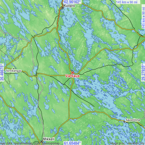
| \ | Map #1 | Map #2 | Topo.Map |
| Scale [m] | 62..120 m | 62..147 m | × |
| Scale [ft] | 203..394 ft | 203..482 ft | × |
| Average | 79.1 m = 260 ft | 82.9 m = 272 ft | × |
| Width | 4.54 km = 2.8 mi | 9.08 km = 5.6 mi | 145.3 km = 90.3 mi |
| Height | 4.54 km = 2.8 mi | 9.08 km = 5.6 mi | 145.3 km = 90.3 mi |
| ↑Max Latitude | 62.33574° | 62.356137° | 62.96162° |
| Latitude at center | 62.31533° | 62.31533° | 62.31533° |
| ↓Min Latitude | 62.294906° | 62.274468° | 61.65484° |
| ← Min Longitude | 27.829055° | 27.785109° | 26.46675° |
| Longitude center | 27.873° | 27.873° | 27.873° |
| →Max Longitude | 27.916945° | 27.960891° | 29.27925° |
Nearby cities:
Cities around Varkaus sort by population:
• Pieksämäki elevation 119 m
38.3 km,  267°
267°
• Leppävirta 114 m
20 km,  346°
346°
• Suonenjoki 104 m
50.7 km,  311°
311°
• Juva 98 m
46.2 km,  181°
181°
• Joroinen 96 m
15.4 km,  187°
187°
• Heinävesi 129 m
39.7 km,  70°
70°
• Rantasalmi 62 m
35.4 km,  141°
141°
• Haukivuori 124 m
47.4 km,  225°
225°
• Vehmersalmi 97 m
50.2 km,  9°
9°
• Kangaslampi 91 m
19.8 km,  96°
96°
• Jäppilä 112 m
23.7 km,  287°
287°
• Virtasalmi 115 m
29.8 km, 225°
Multilingual:
 En español:
Varkaus elevación 76 m.
 En France:
Varkaus élévation 76 m.


Sources and notes:
- [note 1] Map square and city borders are not equal. Map elevation data is calculated only from area inside that square.
- [src 1] Elevation data from geonames database provided with same terms of usage.
- [src 2] The elevation map of Varkaus is generated using GMTED2010 database with 7.5 arcsec (225m) resolution.
- [src 3] Base (background) map © OpenStreetMap contributors tiles are generated by Geofabrik and OpenTopoMap.
Copyright & License:
This Varkaus Elevation Map is licensed under CC BY-SA. You may reuse any part from this page, if you give a proper credit by linking to this URL:
 More info on terms of use page.