Karis elevation
Karis (Uusimaa, Raaseporin), Finland elevation is 34 meters and Karis elevation in feet is 112 ft above sea level [src 1]. Karis is a populated place (feature code) with elevation that is 43 meters (141 ft) smaller than average city elevation in Finland.
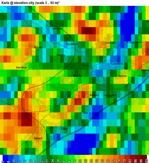
Below is the Elevation map of Karis, which displays elevation range with different colors. Scale of the first map is from 3 to 93 m (10 to 305 ft) with average elevation of 40 meters (=131 ft) [note 1]
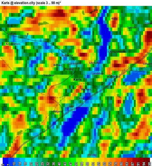
These maps also provides idea of topography and contour of this city, they are displayed at different zoom levels. More info about maps, scale and edge coordinates you can find below images.
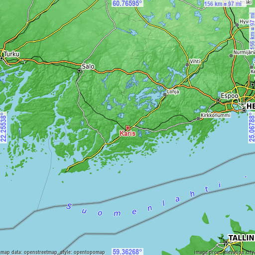
| \ | Map #1 | Map #2 | Topo.Map |
| Scale [m] | 3..93 m | 3..98 m | × |
| Scale [ft] | 10..305 ft | 10..322 ft | × |
| Average | 40 m = 131 ft | 43.7 m = 143 ft | × |
| Width | 4.88 km = 3 mi | 9.75 km = 6.1 mi | 156 km = 96.9 mi |
| Height | 4.88 km = 3 mi | 9.75 km = 6.1 mi | 156 km = 96.9 mi |
| ↑Max Latitude | 60.093698° | 60.115601° | 60.76595° |
| Latitude at center | 60.07178° | 60.07178° | 60.07178° |
| ↓Min Latitude | 60.049848° | 60.027901° | 59.36268° |
| ← Min Longitude | 23.617685° | 23.573739° | 22.25538° |
| Longitude center | 23.66163° | 23.66163° | 23.66163° |
| →Max Longitude | 23.705575° | 23.749521° | 25.06788° |
Nearby cities:
Cities around Karis sort by population:
• Lohja elevation 82 m
29.8 km,  48°
48°
• Ekenäs 8 m
16.7 km,  229°
229°
• Perniö 58 m
32.5 km,  295°
295°
• Pohja 7 m
7.9 km,  290°
290°
• Siuntio 40 m
32.2 km,  76°
76°
• Ingå 1 m
19.2 km,  98°
98°
• Kisko 74 m
20.5 km,  331°
331°
• Karjalohja 48 m
19 km,  9°
9°
• Muurla 15 m
37.3 km, 325°
• Suomusjärvi 105 m
30.9 km,  358°
358°
• Sammatti 59 m
29 km,  17°
17°
• Saukkola 50 m
38.9 km,  27°
27°
Multilingual:
 En español:
Karis elevación 34 m.
 En France:
Karis élévation 34 m.


Sources and notes:
- [note 1] Map square and city borders are not equal. Map elevation data is calculated only from area inside that square.
- [src 1] Elevation data from geonames database provided with same terms of usage.
- [src 2] The elevation map of Karis is generated using GMTED2010 database with 7.5 arcsec (225m) resolution.
- [src 3] Base (background) map © OpenStreetMap contributors tiles are generated by Geofabrik and OpenTopoMap.
Copyright & License:
This Karis Elevation Map is licensed under CC BY-SA. You may reuse any part from this page, if you give a proper credit by linking to this URL:
 More info on terms of use page.