Siuntio elevation
Siuntio (Uusimaa, Helsinki), Finland elevation is 40 meters and Siuntio elevation in feet is 131 ft above sea level [src 1]. Siuntio is a seat of a third-order administrative division (feature code) with elevation that is 37 meters (121 ft) smaller than average city elevation in Finland.
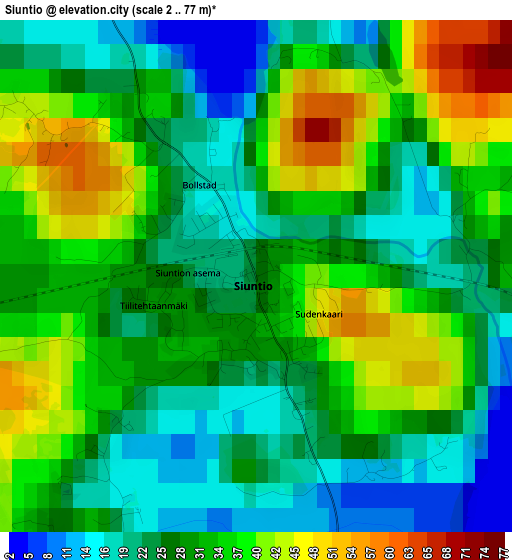
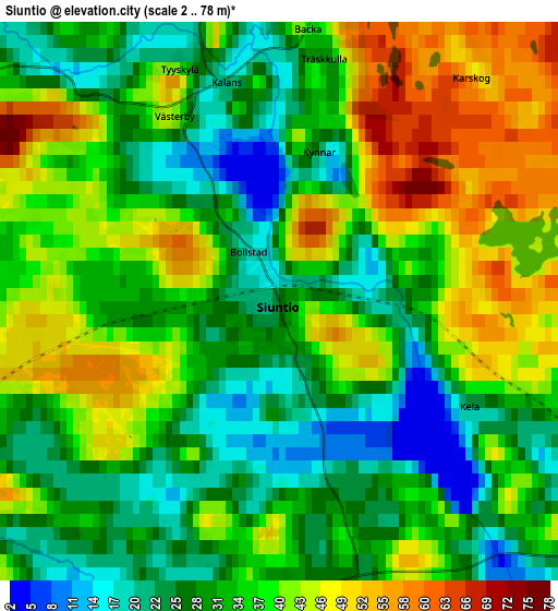
Below is the Elevation map of Siuntio, which displays elevation range with different colors. Scale of the first map is from 2 to 77 m (7 to 253 ft) with average elevation of 29.8 meters (=98 ft) [note 1]
These maps also provides idea of topography and contour of this city, they are displayed at different zoom levels. More info about maps, scale and edge coordinates you can find below images.
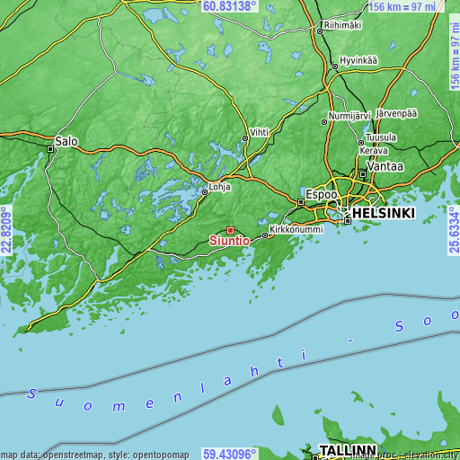
| \ | Map #1 | Map #2 | Topo.Map |
| Scale [m] | 2..77 m | 2..78 m | × |
| Scale [ft] | 7..253 ft | 7..256 ft | × |
| Average | 29.8 m = 98 ft | 35 m = 115 ft | × |
| Width | 4.87 km = 3 mi | 9.73 km = 6 mi | 155.7 km = 96.7 mi |
| Height | 4.87 km = 3 mi | 9.73 km = 6 mi | 155.7 km = 96.7 mi |
| ↑Max Latitude | 60.160493° | 60.182352° | 60.83138° |
| Latitude at center | 60.13862° | 60.13862° | 60.13862° |
| ↓Min Latitude | 60.116732° | 60.09483° | 59.43096° |
| ← Min Longitude | 24.183205° | 24.139259° | 22.8209° |
| Longitude center | 24.22715° | 24.22715° | 24.22715° |
| →Max Longitude | 24.271095° | 24.315041° | 25.6334° |
Nearby cities:
Cities around Siuntio sort by population:
• Espoo elevation 16 m
24.6 km,  72°
72°
• Lohja 82 m
15.1 km,  323°
323°
• Kirkkonummi 17 m
11.8 km,  98°
98°
• Vihti 39 m
31.4 km,  9°
9°
• Kauniainen 41 m
28.9 km, 73°
• Ingå 1 m
16.1 km,  230°
230°
• Kilo 24 m
31.9 km, 74°
• Karjalohja 48 m
30.3 km,  291°
291°
• Gumböle 39 m
23.3 km, 67°
• Sammatti 59 m
30.2 km,  311°
311°
• Koukkuniemi 1 m
29.8 km,  87°
87°
• Saukkola 50 m
30.4 km,  333°
333°
Multilingual:
 En español:
Siuntio elevación 40 m.
 En France:
Siuntio élévation 40 m.


Sources and notes:
- [note 1] Map square and city borders are not equal. Map elevation data is calculated only from area inside that square.
- [src 1] Elevation data from geonames database provided with same terms of usage.
- [src 2] The elevation map of Siuntio is generated using GMTED2010 database with 7.5 arcsec (225m) resolution.
- [src 3] Base (background) map © OpenStreetMap contributors tiles are generated by Geofabrik and OpenTopoMap.
Copyright & License:
This Siuntio Elevation Map is licensed under CC BY-SA. You may reuse any part from this page, if you give a proper credit by linking to this URL:
 More info on terms of use page.